
California
![]()
State Rock: Serpentine
CHAPTER 89
An act to add Sections 4-25.1 and 4-25.2 to the Government Code. relating to state emblems.
The people of the State of California do enact as follows:
SEC. 2. Section 425.2 is added to the Government Code, to read:
425.2. Serpentine is the official State Rock and lithologic emblem.
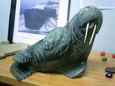
A 2012 carving by Jonah Akpalialuk de Pangnirtung Nunavut of a walrus in serpentine. Image courtesy of Hugh.macisaac CC BY-SA 3.0.
Serpentine is a green to black, fibrous and platy, metamorphic rock. It was metamorphosed from the ultramafic (dark green minerals like olivene) rock peridotite. It was named for the serpent skin-like pattern formed by the multitude of greens throughout the rock. The original parent rock, peridotite, was deposited in the ocean, below the basalt and other crustal rocks. The high heat, water, and high pressure converted the peridotite into serpentine. Serpentine itself is often composed of three main minerals, chrysotile (Mg3Si2O5(OH)4, a fibrous mineral, often found in the form asbestos), lizardite (Mg3(Si2O5)(OH)4), and antigorite ((Mg,Fe)3Si2O5(OH)4), among others. Most of the minerals within the serpentine group have very similar chemical formulas, being generally magnesium-iron silicates. Even though they have very similar chemistries, it is their different structures that identify them as unique minerals (like a diamond and graphite both are just composed of carbon). Serpentine has a variety of uses including ornamental stone, due to its distinctive green color and soft texture. The minerals range in hardness from 3 to 6, making them easy to carve but fairly resistance to weathering. Serpentine is also known for its ability to resist heat, making it a valuable insulator and the primary reason it became into such widespread uses. Asbestos, made from the serpentine mineral chrysotile, was once a major industrial mineral, however the discovery of diseases associated with inhaling powdered asbestos has significantly impacted the importance of this mineral.
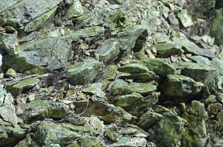
Outcrop of serpentine from the Paradise Serpentine Barrens by Wildflower Hikes.
Serpentine has an important place in the geological history of California. California was formed by the accretion of various islands and oceanic material as the North American plate moved westward and the subduction zone along the west coast of North America (where the westward lying Farallon Plate went underneath North America) allowed material to be "scraped" off of the subducting plate. These landforms that were scraped off the subducting plate were called "accretionary provinces" and they contained large pockets of serpentine within them. These accretionary provinces provided California with an abundance of valuable serpentine minerals including chrysotile, as well as chromite, magnesite, and cinnabar. For this reason, as well as its soft nature making it an easy stone to polish and use as an ornamental rock, it was designated as California's state rock. The ever-presence of serpentine within California is so strong that there are several forms of plant life that have evolved and thrive within the serpentine rich soil. Typically these soils would be toxic to most plant life due to the high amounts of magnesium and iron within the soil, but as Ian Malcolm said, life finds a way. Currently there are several species of plants that adapted to these types of soils that are distinctive enough from the neighboring soils that scientists can identify the soil just by looking at the plants, termed "serpentine plants". The formation and accretion of serpentine also is an indicator of other minerals within the region. Just the presence of serpentine could indicate other heavy metals such as gold, silver, and copper, since all of these minerals are related to the metamorphism and hythrothermal activity that can form serpentine. Unfortunately, due to the strong association of serpentine with asbestos, there has been recent urges to change or remove the state rock. Having the state rock associated with cancer is not something many lawmakers agree with. Scientists contend though, that asbestos within its natural state is harmless. Only when powdered, can asbestos become a carcinogen. Currently it is unsure whether the rock will be removed as the state rock.
State Mineral: Gold
CHAPTER 89
An act to add Sections 4-25.1 and 4-25.2 to the Government Code. relating to state emblems.
The people of the State of California do enact as follows:
SECTION 1. Section 423.1 is added to the Government Code, to read:
425.1. Native gold is the official State Mineral and mineralogic emblem.
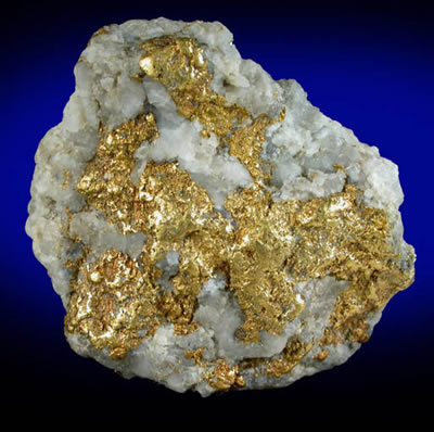
Gold in quartz from Hangtown, Placerville, El Dorado County, California.
Photo courtesy of johnbetts-fineminerals.com.
The chemical symbol for gold is Au, and gold is one of the unique minerals that, in its pure form, is composed entirely of one element. It has a hardness of 2.5 to 3 on the Mohs hardness scale meaning that it actually is very soft (your fingernail is 2.5). For this reason most gold jewelry is mixed with another metal to prevent scratching and bending easily. The karat rating of the gold represents it's purity, where 24 karat is 99.9% pure, 22 karat 91.7%, 18 karat 75%, and so on. Gold naturally does not corrode or tarnish, so even when it is mixed with other metals it usually has a resistance to tarnishing, enhancing its value for jewelry. When gold is found in place, the highest grade of gold is often found in association with quartz veins. Currently gold is considered one of the most valuable metals on Earth, being used as the standard for most money (gold standard). Gold is often formed initially in relation to volcanic regions, where fluids associated with volcanoes carry the heavy metals up towards the surface and deposit them in rocks. These are found in areas of current or former subduction zones, places where two plates came together forcing one place down and melting it, while the other plate is forced upwards into mountains. Afterwards, erosion will take the gold out of the mountains and carry them down stream. However, since gold is so dense it does not travel easily down rivers and will often settle to the bottom of the river within the rocks and mud within the river sediment. These gold deposits are known as placer deposits and are the primary place where gold panners find gold. They can then use the locations of these placer deposits to backtrack to the original sources of the gold within the streams.
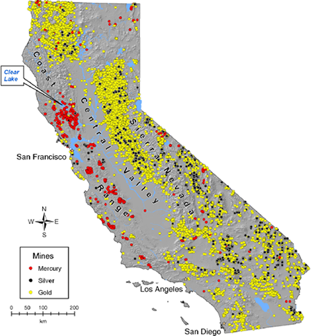
Gold was initially discovered in California in 1848 at Sutter's Mill in Coloma. This discovery eventually brought on the Gold Rush of 49' (the name of the 49ers are based on this gold rush as well). The Gold Rush increased the number of people in California from pre-1849 to post-1849 100 times (going from less than 1,000 to over 100,000). The discovery of gold and sudden influx of people to California, caused it to have statehood decades before most of the other western states. Overall, ~$2,000,000,000 worth of gold was extracted from the state during this time period. The current slogan for California, "The Golden State", is due to this foundation on gold. California's gold mines (current and historic) cover the entire state and can be found from the very southern border all the way to the northern border, with almost every county having at least one (as seen in the map to the left). The formation of this gold is directly tied to the former subduction zone that was located off of the western coast of California (the now San Andreas strike-slip fault). As was mentioned above in the Serpentine section, California was formed from the accretionary provinces from this subduction zone that lastest around 200 million years, and is still continuing today along the coast of Oregon and Washington. As the subduction zone forces one plate downwards, that downward plate begins to melt, forming volcanoes. Most of the volcanoes located within California today (both active and extinct) are due to this subduction zone. Along with the volcanism, is a large amount of hydrothermal fluids working their way through the rock. These hydrothermal fluids carry large amounts of heavy metals including gold, silver, copper, and many others from deep down in the crust up towards the surface. As these fluids work their way through the overriding plate, they deposit these heavy metals, creating the gold deposits that are so well known in California. As these deposits then start to erode from the mountains, the high specific gravity of gold (high density) and its resistance to oxidizing (tarnishing) causes the gold to concentrate on the bottom of river beds forming what are called placer deposits. It is from these deposits that people find gold while they perform the famous "wild west" practice of panning for gold.
Related: Alaska State Mineral - Gold; North Carolina State Mineral - Gold; South Dakota State Jewlery - Black Hills Gold
State Gemstone: Benitoite
CHAPTER 1365
An act to add Section 425.3 to the Government Code, relating to the state gemstone.
The people of the State of California do enact as follows:
SECTION l. Section 425.3 is added to the Government Code, to read:
425.3. Benitoite is the official state gemstone.
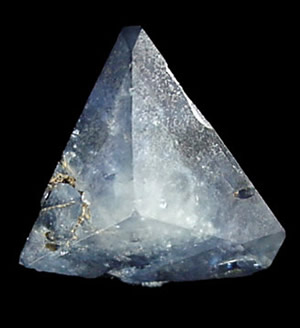
Benitoite from Benitoite Gem Mines, San Benito County, California.
Photo courtesy of johnbetts-fineminerals.com.
Benitoite is an extremely rare mineral where the only gem quality stones are found in California. It is often found as a blue to dark blue mineral but can be purple, pink, white, and colorless that also fluoresces blue under ultraviolet light. Benitoite is a barium titanium silicate (BaTiSi3O9) that often forms pyramidal crystals, although the crystals are usually 5 cm or less in size. It was initially found near the headwaters of the San Benito River, in San Benito County, California, and was named for its discovery location. When benitoite was originally discovered it was thought to be another variety of sapphire. However, further analysis by some jewelers ruled out the gem as a sapphire, mainly due to the hardness of the mineral. A sapphire has a hardness of 9 on Moh's Hardness Scale, while benitoite has a must softer hardness of 6-6.5. In 1907, George D. Louderback, identified and named the unique and very rare mineral. Primarily benitoite is known as a collector's item with a small amount of samples being used to align and adjust electron microprobe beams. Benitoite is found within natrolite veins that are interlayered with serpentine. Benitoite forms from the hydrothermal altering of the serpentinite, a primary mineral found within the state rock, serpentine.
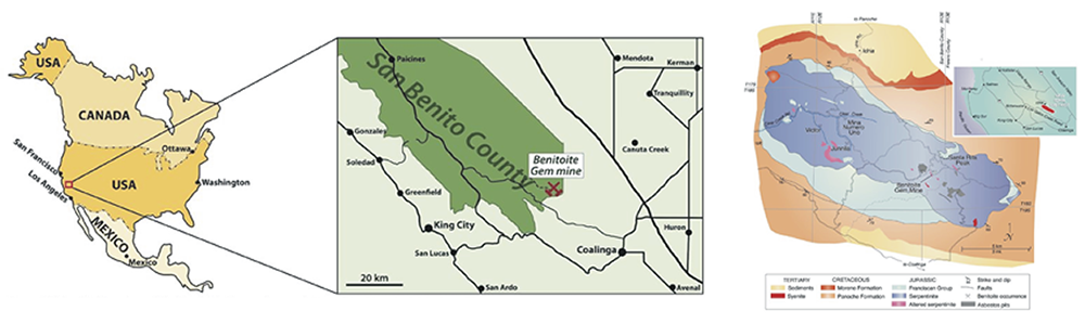
Map of the location of the Benoite Gem Mine. The map is courtesy of Laurs et al., 1997 and collectorsedge.com.
Currently, gem quality benitoite is only known to occur in the one location that it was originally discovered in, known usually at the Benitoite Mine (as mapped above). Upon discovery of the gems, they were found within another mineral, natrolite. The natrolite was a blessing and a curse. Natrolite was great because it protected the crystals from being damaged, however when trying to remove the benitoite crystals from the natrolite many crystals were damaged in the process. Modern methods of dissolving the natrolite though has enabled a much larger number or gem quality stones to be removed from the mine. However rare and valuable the gem is, collectors and rock hounds have the unique chance to collect their own specimens of benitoite by going to the California State Gem Mine. Where, for a fee, you can try and find some of the gems yourself. The uniqueness of the mineral and the high quality that it produces makes it the ideal state gemstone. Especially given how tied into the local geology it is, having been formed in conjunction with the other state symbols, serpentine and gold.
State Fossil: Smilodon fatalis (saber-toothed cat)
CHAPTER 792
An act to add Section 425. 7 of the Government Code, relating to State Fossil.
The people of the State of California do enact as follows:
SECTION 1. Section 425.7 is added to the Government Code, to read:
425.7. The saber-toothed cat (Smilodon californicus) is the official State Fossil.
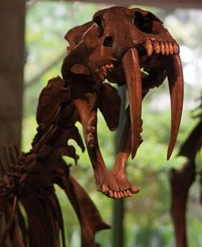
Fossil of Smilodon fatalis found in the La Brea Tar Pits. Image courtesy of tarpits.org.
Smilodon fatalis, more commonly known as the saber-toothed cat, is member of the Felidae family that went extinct around 10,000 years ago, towards the end of the last ice age. Although, frequently called a "tiger" Smilodon is not actually closely related to modern day tigers, or any modern day cat really. Smilodon falls into the subfamily, Machairodontinae, which is separate from all modern day cats. Smilodon fossil remains are known from North America and the Pacific regions of South America. Although, often depicted as living in caves, Smilodon fatalis is more commonly found within plains or woodland deposits, and likely lived as an ambush predator. The skeleton of Smilodon supports this theory, since it is robust with a short tail, indicated it did not run down its prey. Smilodon fatalis grew up to 5-7 feet long and 3.5 feet high at the shoulder, weighing ~350-600 lbs. Originally, it was thought that the saber teeth were used to grapple and hold on to the prey, however they are not strong enough to do this and would result in a lot of broken teeth. It is now hypothesized that the saber teeth were used to deliver a mortal stab wound while the animal then waited for its prey to die. Smilodon fatalis was initially described in 1868 by Leidy from a sample found in Texas.
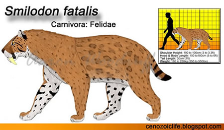
Reconstruction of Smilodon fatalis. Image courtesy of cenozoiclife.blogspot.com.
Over 130,000 different Smilodon specimens (at least 2,000 individuals) have been found in California, primarily within the Rancho La Brea asphalt deposits (the tar pits) and is the second most common animal found there. The La Brea Tar Pits formed from crude oil that seeped to the surface and partially evaporated, leaving only the heavy tar behind. Animals would get stuck, and eventually enveloped, by the tar after they died from lack of food or water. The Smilodon bones found within the pits were discovered to have what would normally be debilitating injuries that had healed over. This indicates that these animals were possibly cared for by other saber-toothed cats, as in a familial setting. So unlike most cats which are solitary hunters, Smilodon appeared to be a pack animal, similar to modern day lions.
State Dinosaur: Augustynolophus morrisi
AB 1540
Purpose of the bill. According to the author’s office, “the Augustynolophus morissi is a unique dinosaur that has only been found in California. Seven states, as well as the District of Columbia, have declared a state dinosaur to pay homage to the original creatures to walk the land. California now has the opportunity to recognize an important part of our history. A state dinosaur is essential to California’s society because it nurtures an educational opportunity for the youngest Californian’s to become interested in paleontology, and S.T.E.M (Science, technology, engineering, and mathematics) as a whole.”
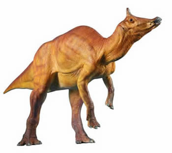
Augustynolophus morissi. The Augustynolophus morissi is a saurolophine hadrosaur dinosaur. Hadrosaurs are also known as the duck-billed dinosaurs. Additionally, Augustynolophus morrisi is a herbivorous dinosaur.
Due to many geological and geographical factors, the record of dinosaurs within California is quite slim. Augustynolophus morissi roamed California during the Maastrichtian Age, which makes it a contemporary of other well-known dinosaurs such as Tyrannosaurus and Triceratops. The fossils have been found nowhere else in the world.
The Augustynolophus morissi specimens were discovered, between 1939 and 1940, by crews from the California Institute of Technology who collected two partial hadrosaurid skeletons from Moreno Formation of the Panoche Hills of Fresno County. It was originally thought that these animals belonged to an already-known genus – Saurolophus – however, when a more in-depth study took place, it was revealed that the cranial structure was vastly different, and therefore, determined to be a separate species.
The species is named after two notable Californians. The generic name derives from a combination of Mrs. Gretchen Augustyn and the suffix "-lophus," referring to its relation to Saurolophus. The specific name refers to paleontologist, Dr. William J. Morris.
AB 1540 designates the Augustynolophus morrisi as the state dinosaur.
Augustynolophus morrisi is a hadrosaurid dinosaur from the Panoche Hills of Fresno County, California. The holotype specimen was originally collected in 1939-1940 and was initially identified as a new species of Saurolophus. Another specimen was discovered and collected in 1941 with the same diagnosis. Recently, further preparation of the skull material (pictured below) warranted naming the dinosaur as a new genus, Augustynolophus (Prieto-Márquez et al., 2014). The identification of the new genus was based on the unique nasal crest. Hadrosaurid dinosaurs are herbivorous dinosaurs that can be broken into two major clades (groups), the hollow-crested Lambeosaurinae (such as Parasaurolophus) and the non-crested/solid-crested Saurolophinae, of which Augustynolophus is a member. The group of dinosaurs that now contains Saurolophus and Augustynolophus is known as the Saurolophini Tribe and is found right up until the End Cretaceous extinction event, with Augustynolophus being found in the 66 million year old Moreno Formation.
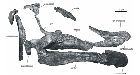
The fossilized remains of Augustynolophus morrisi.
Image courtesy of Prieto−Márquez and Wagner, 2013.
The genus name Augustynolophus is in honor of Mrs. Gretchen Augustyn and her family, who had been instrumental supporters of the Dinosaur Institute of the Natural History Museum of Los Angeles County. The species name, morrisi, is named for paleontologist William J. Morris (1923-2000), who had significant contributions to the understanding of hadrosaurid dinosaurs Pacific Coast and the Western Interior of North America. The dinosaur was chosen as the state dinosaur in part to boost enthusiasm for paleontology and to highlight one of the few dinosaur fossils found within the state of California, which did not have much land above sea level during the Mesozoic.
References
https://statesymbolsusa.org/states/united-states/california
http://www.library.ca.gov/history/symbols.html
http://www.conservation.ca.gov/cgs/information/publications/cgs_notes/note_14/Documents/note_14.pdf
http://www.statesymbolsusa.org/California/CAstatesymbolrock.html
http://www.netstate.com/states/symb/rocks/ca_rock.htm
https://www.minerals.net/mineral/serpentine.aspx
https://wildflowers.russellramblings.com/2013/03/paradise-serpentine-barrens/
https://botanicalgarden.berkeley.edu/wp-content/uploads/2016/05/Newsletter-1993-2.pdf
http://www.nytimes.com/2010/07/14/us/14rock.html?_r=0
http://www.zales.com/jewelry101/index.jsp?page=preciousMetals
http://www.consrv.ca.gov/cgs/information/publications/cgs_notes/note_12/Documents/Note%2012.pdf
http://commons.wikimedia.org/wiki/File:US_states_by_date_of_statehood_red.PNG
http://www.history.com/topics/gold-rush-of-1849
Wiener, J. G. and Suchanek, T. H. (2008), THE BASIS FOR ECOTOXICOLOGICAL CONCERN IN AQUATIC ECOSYSTEMS CONTAMINATED BY HISTORICAL MERCURY MINING. Ecological Applications, 18: A3-A11. doi:10.1890/06-1939.1
https://geology.com/gemstones/benitoite/
https://collectorsedge.com/pages/benitoite-gem-mine
http://www.johnbetts-fineminerals.com/jhbnyc/mineralmuseum/picshow.php?id=13478
http://www.consrv.ca.gov/cgs/information/publications/cgs_notes/note_11/Documents/note_11.pdf
http://www.calstategemmine.com/
http://www.mindat.org/min-624.html
http://webmineral.com/data/Benitoite.shtml#.U9qQufldXgU
http://rruff.info/doclib/hom/benitoite.pdf
http://library.sandiegozoo.org/factsheets/_extinct/smilodon/smilodon.htm
http://cenozoiclife.blogspot.com/2015/06/saber-toothed-cat-smilodon-fatalis.html
http://www.ucmp.berkeley.edu/mammal/carnivora/sabretooth.html
http://www.ucmp.berkeley.edu/quaternary/labrea.html
http://www.tarpits.org/museum/exhibits
https://www.floridamuseum.ufl.edu/florida-vertebrate-fossils/species/smilodon-fatalis
http://www.ucmp.berkeley.edu/mammal/carnivora/sabretooth.html
https://nhm.org/site/research-collections/rancho-la-brea/about-rlb-mammals
ALBERT PRIETO-MÁRQUEZ, JONATHAN R. WAGNER, PHIL R. BELL, LUIS M. CHIAPPE; The late-surviving ‘duck-billed’ dinosaur Augustynolophus from the upper Maastrichtian of western North America and crest evolution in Saurolophini. Geological Magazine ; 152 (2): 225–241. doi: https://doi.org/10.1017/S0016756814000284
https://clerk.assembly.ca.gov/archive-list?archive_type=statutes
Geology of California's National Parks
Through Pictures
(at least the one's I have been to)
Fort Point National Historic Site
Golden Gate National Recreation Area
Visited in 2016
Our last park on our 2016 tour of the southwest's desert national parks was Death Valley. The hottest, driest, and lowest National Park. Also the lowest point in the Western Hemisphere. We entered the park at the southern entrance, which enabled us to hit up Badwater Basin on our way into the park, since that was the main thing I wanted to see. Unfortunately, we were getting there right at sunset so the sun is in a lot of the photos, since we were on the eastern side of the valley.
.jpg)
Drive by Entrance Sign shot.
.jpg)
Our first view of valley known as Death Valley on our way towards Badwater Basin. The valley was formed during the expansion of the western United States creating the region known as the Basin and Range province. Initially the United States was being squeezed by a large plate off the west coast known as the Farallon Plate. This plate was slide beneath North America while also pushing up against North America. Eventually most of that plate complete subducted (went beneath) North America. At that point the pressure was off and North America began expanding outwards like a squeezed sponge. This outward expansion produced a series of linear mountains alternating with linear valleys, the Basin and Range. This region extends from mid-Utah, through Nevada, and into eastern California.
.jpg)
Distant view of Badwater Basin towards the north.
.jpg)
Here is a shot while standing in Badwater Basin, the lowest point in the Western Hemisphere (282 feet below sea level). This view is looking towards the east, up at the valley wall. If you look closely there is a little white box towards the center of the photo. The box says "Sea Level".
.jpg)
The salt that has accumulated at the bottom of Badwater Basin. Badwater Basin is a terminal basin, meaning that all of the water that flows into this basin, stays here, until it evaporates away. This means that all of the minerals from the surrounding landscape also get deposited here and stay here. This causes many end basins to have very, very high concentrations of minerals like halite (salt) and gypsum. A similar terminal basin is the Great Salt Lake, also with a very high salt content.
.jpg)
Looking out towards the basin along the salt walkway that the tourists are allowed on. You will notice all the holes. I'm positive these are people digging them, then going "Now I'm at the lowest point!". Please don't do do this. Those people are just jackasses and breaking the law.
.jpg)
Another view of Badwater Basin.
.jpg)
Close up shot of the salt flats. Love the designs in the salt.
.jpg)
Looking back towards the "Sea Level" sign and the valley wall.
.jpg)
The marker stating "Badwater Basin 282 Feet/85.5 Meters Below Sea Level".
.jpg)
The car's altimeter was a little off, but it was still cool to see it say -260 ft.
.jpg)
View from our room at the Stovepipe Wells Village looking at the Mesquite Flat Sand Dunes.
.jpg)
Got out and hiked around the dunes a little.
.jpg)
Interdunal deposits.
.jpg)
Traces of dune life. Looks like lizards and mice to me.
.jpg)
More tracks. Maybe a hare mixed in and I'm sure there were scorpion tracks in there somewhere.
.jpg)
Furnace Creek visitor's center, which is the location for the hottest place on Earth. It was only 85 while we were there, so not too bad. The reason that Death Valley holds the record for being the hottest places on Earth, and is also one of the lowest places on Earth are not separate isolated instances. The valley floor is so low, and the surrounding mountains so high, that the air currents within the valley can't escape during the hot summer months. So as the sun heats up the valley it isn't able to cool down at night very much because the air is trapped in the valley. Come the daytime that slightly cooled air descends back down to the surface and heats up even more. It's a cyclical cycle that produces incredibly hot temperatures.
.jpg)
Went over to Artist's Drive. View of the valley wall. The expansion of the crust also thinned the crust. This thinning allowed magma to start leaking through and producing volcanoes in various places along the expansion region. These volcanoes eventually moved towards the east but not before producing volcanic eruptions including ash and lava. The rocks in this area specifically are heavily composed of that ash, which is rich in heavy minerals and elements like nickel and cobalt. When these heavy metal elements start to erode, they produce vibrant colors not typically seen in a normal sedimentary landscape.
.jpg)
Another view of the valley wall along Artist's Drive.
.jpg)
Looking out towards Death Valley from Artist's Drive.
.jpg)
Artist's Palette. This was an extremely colorful ash and claystone deposit, made colorful by the various metals in the ash. The colors got a little washed out in the photo but they were rather striking in person.
Fort Point National Historic Site
Visited in 2018
The last National Park we visited on this trip was within the Golden Gate National Recreation Area.
.jpg)
Our entrance sign traditional pic with the Golden Gate Bridge and part of Fort Point in the background.
.jpg)
View of the fort from above. As you can partially see in this photo, the Fort sits on a promontory within the Golden Gate (the waterway). Promontories have an effect on the water that bends waves into them, forcing them to become eroded much faster than the surrounding areas. For that reason, the Fort is at a much higher risk of erosion than much of the surrounding land.
.jpg)
This sign goes into much of the detail of that erosion. Combine the risk of erosion just based on its physical location within the Golden Gate, but also the risk of sea-level rise due to climate change and you have a National Historic Site that is at significant risk to loss at some point in the future. This sign goes into many of the details of the risks of this location:
"In the 1850's, the US Army ranked this exposed, windy, and wave-beaten point as ideal for a major fortification to defend San Francisco Bay. This Civil War-era fort never faced enemy fire but is now under attack by rising seas and bigger storm waves. Earth's warming temperatures-mostly caused by human actions like burning fossil fuels-are melting glaciers, expanding sea water, and increasing storm intensity. How can we continue the army's legacy of defending our coasts in the face of sea level rise?"
.jpg)
Panoramic view of Fort Point with the Golden Gate Bridge overhead.
Golden Gate National Recreation Area
Visited in 2018
Continuing our trip from the Muir Woods National Monument, we then travailed some of the Presidio's national parks, including taking pictures of the Golden Gate Bridge itself. We weren't able to visit a lot of the surrounding areas of the park but hopefully we will be able to visit them at a future date.
.jpg)
Arriving at the Golden Gate Bridge we went to take in the overlook of the bridge and got an eyeful of the famous San Francisco fog. The fog is produced when the hotter air located within the city itself and the surrounding areas come in contact with the cool air blowing in off the Pacific ocean. When these two air masses come in contact, the warmer air is forced upwards creating clouds, or in this instance, fog.
.jpg)
Eventually the bridge did come out to visit us (at least most of it). From here you can barely see the Marin Headlands across the Golden Gate (the name of the body of water in which the bridge crosses). These rocks were instrumental in understanding the plate tectonics of California and the former subduction zone that was eventually transformed into the San Andreas Fault Complex. The Marin Headland rocks are mostly composed of jumbled up deep marine rocks including cherts and basalts.
.jpg)
Across the way is also Alcatraz, which is another national park. So we will save the description of that one until I'm actually able to visit it.
.jpg)
Here is one of the various walking trail tunnels that can be found within the bridge area trails. I'm not really sure their purpose.
.jpg)
View of the bridge and the Marin Headlands from down below the bridge.
Visited in 2016
The second stop in California on our trip across the Southwest, we came to Joshua Tree. Not actually knowing what a "Joshua Tree" was, I became enlightened. That and the desert landscapes are gorgeous here.
.jpg)
Obligatory entrance sign. Joshua Tree NP has one main road that traverses the park. We started at the south end and traveled northwest.
.jpg)
Joshua Tree NP entails two separate desert ecosystems. The Sonoran Desert (AKA The Colorado Desert in this area, which is a subset of the Sonoran Desert). The Sonoran Desert is the desert of the major cacti. It contains the cholla cactus and the saguaro cactus. This is a view across the Sonoran Desert within the park.
.jpg)
Another view of the desert with some ocotillo on the left and right of the image at the Ocotillo Patch. They really are the coolest desert plants ever.
.jpg)
The Cholla Cactus Garden, with thousands of cholla cacti across the area.
.jpg)
Crossing over into the higher altitude Mojave Desert. This desert is the home to the Joshua tree. Here we have some of the awesome granite rock formations. All of the granite in the park is heavily jointed and eroded, giving it these cool "stacked rocks" type appearance.
.jpg)
Lunch among the boulders at White Tank.
.jpg)
Some more granite (monzogranite) boulders at White Tank.
.jpg)
A nice series of straight joints running through the monzogranite at White Tank.
.jpg)
Joshua Tree!!!
.jpg)
A nice outcrop of monzogranite with a cluster of Joshua Trees in the foreground.
.jpg)
An upclose view of the monzogranite. I apologize for the lack of scale.
.jpg)
Looking up through a "cave" created by the boulders.
.jpg)
Because...Joshua Tree
.jpg)
Landscape of the Mojave Desert.
.jpg)
More Mojave Desert landscape.
.jpg)
More nice rock formations with Joshua Trees.
.jpg)
Some more nice rock formations.
.jpg)
And a parting Mojave Desert shot.
Visited in 2019
During the summer of 2019, we decided to take the trailer on our longest trip yet, to Crater Lake. Along the way we camped at Lassen Volcanic National Park. The main campground was full by the time we made reservations so we ended up at the out of the way Butte Lake campground.
.jpg)
Since our campground was so out of the way, we needed to wait till the next day when we entered the main part of the park to grab our entrance sign shot.
.jpeg)
Lassen Peak is the remnant of a once much larger volcano, Mount Tehama, that erupted leaving behind a 2 mile wide caldera located between the surrounding mountains of Lassen Volcanic National Park.
.jpeg)
The peaks of the surrounding mountains can be seen here. These outer mountains represent the edge of Mount Tehama (also known as Brokeoff Volcano) that measured ~11 miles across and rose to ~11,500 feet, 1,000 feet higher than modern day Lassen Peak.
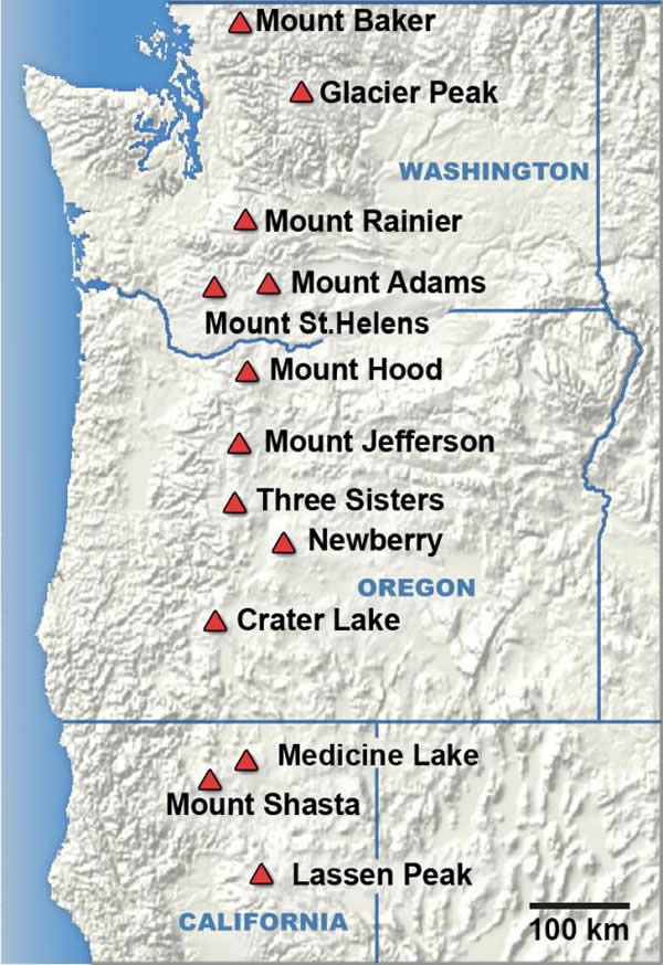
Lassen Peak is the southernmost volcanoes in the Cascade Range, a series of volcanoes that stretch up into Canada along the Pacific Northwest coast. Image courtesy of the USGS.
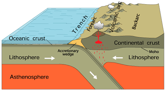
These volcanoes formed from a process called subduction. The crust of the Earth is broken up into very large pieces called plates. These plates move around, with some sliding past each other, some pulling apart from each other, and others going towards each other. The edge of these plates are where earthquakes frequently occur, due to the rubbing of the plates against each other. When a plate composed mostly of oceanic crust goes toward a plate composed mostly of continental crust, the denser oceanic crust gets forced downwards into the Earth. This area is known as a subduction zone. As the denser oceanic plate moves downwards into the Earth it starts to heat up and eventually melt. That liquid rock rises up through the crust forming a string of volcanoes called a volcanic arc. The Cascade Range is such an arc with Lassen Peak representing the southernmost extent of the subduction zone. Image courtesy of the USGS.
.jpeg)
There are many different types of volcanoes. Here is a view of Lassen Peak in the distance, rising up to 10,457 feet in elevation. It is so high that during our trip at the end of June it is still entirely covered in snow. Lassen Peak is what is known as a "Plug Dome", this forms when the lava is too thick to flow great distances. Lava rich in silica (quartz), has a higher viscosity (thickness) and doesn't flow as far as thinner, basaltic magma, which is hotter and has less silica content.
The original Mount Tehama was known as a "composite volcano", which means that it was composed of alternating layers of ash, lava flows, rock fragments, and cinders that slowly piled up over time from smaller eruptions. Most of the volcanoes in the Cascades are composite volcanoes. Mount Tehama was active with frequent eruptions from about 600,000 to 400,000 years ago until the magma shifted and the volcano, losing its magma, started to collapse and erode away.
.jpeg)
Once we reached the highest part of the road way at Lassen Peak, the snow really was still piled up. Here is a view of the snowfields along Lassen Peak at ~8,500 ft.
.jpeg)
Along the main road there were a lot of glacial and volcanic features. Here is Emerald Lake, which is known as a "tarn". A tarn is a glacial lake that was formed when a glacier erodes a divot out of the side of a mountain. When a glacier sits on the side of the mountain, snow slowly accumulates on the top portion of it. As more snow is added the entire glacier starts to get pulled down the mountain by gravity. This movement down the mountain causes the bottom surface of the glacier to erode the side of the mountain out, like an ice cream scoop. Eventually a bowl shaped depression is formed, called a cirque, where sometimes those bowl shaped depressions are able to hold water and a lake is formed, called a tarn.
.jpeg)
Within the central part of the caldera, towards the bottom of the valley between the mountains, is a large hydrothermal area. The hydrothermal area contains many features that are heated up from the rich source of magma that still resides below the surface. This particular area is known as the Sulphur Works, which does have that glorious rotten egg smell, but there are a few other hydrothermal areas within the park. What is seen here is a mudpot which is produced when ground water flows down into the surface and interacts with the magma and volcanic gasses deep down. That heated water then rises back through the crust and heats up the water within the streams and groundwater coming down from the surface. This heated water produces steam that we see within other features and heats up puddles of water and mud such as this mudpot.
.jpeg)
Hydrothermal features also have a tendency to have very vivid colors from the heavy minerals that get brought to the surface by the groundwater from the magma. Here is another portion of the Sulphur Works, looking out into the lower parts of the caldera.
.jpeg)
Out towards the eastern edge of Lassen Volcanic National Park is Butte Lake, which borders the Fantastic Lava Beds. The Fantastic Lava Beds and Cinder Cone, which is seen in the background, were formed from an eruption in ~1650 CE. A Cinder Cone is another type of volcano which is produced from the eruption of black chunks of rocks, typically referred to as cinders or the rock type scoria. In this image you can even see Lassen Peak sticking out behind Cinder Cone slightly to the left of the cone.
.jpeg)
Here is one of the edges of the Fantastic Lava Beds. The Fantastic Lava beds are formed from a basaltic lava flow, meaning that the lava had a low viscosity and a dark color, containing a high amount of iron in it, low amount of gasses, and low amount of silica. The silica (quartz) gives lava a thicker, viscous quality, like the lava that forms the plug dome at Lassen Peak.
.jpeg)
You can actually hike to the top of the Cinder Cone as well, which was initially protected by Theodore Roosevelt as Cinder Cone National Monument in 1907 before being rolled into Lassen Volcanic National Park. While hiking up the volcano you can really feel the loose pile of cinders that create the volcano. A cinder cone is formed as a volcano sputs and spurts lava into the air. The air then quickly cools the lava forming holey, light pieces of rock called scoria. The smaller chunks of rock are spit out further while the larger chunks stay near the vent. Over time the chunks are built up around the vent forming the cone.
.jpeg)
Here is a view from the top of the Cinder Cone looking out onto the Fantastic Lava Beds and Butte Lake in the distance.
.jpeg)
A view into the center of the cinder cone. At the base of the crater there is nothing of interest that I had hoped for. Somebody had apparently built up a chimney structure with rocks at the base of the crater, but otherwise it is just a flat smooth surface.
.jpeg)
Here is an overview of the lava beds and the Cinder Cone to give you an overview of the area.
References
https://www.volcanocafe.org/mount-tehama-brokeoff-mountain-and-the-lassen-volcanic-national-park/
https://www.usgs.gov/news/earthword-subduction
https://volcanoes.usgs.gov/observatories/cvo/cascade_volcanoes.html
http://npshistory.com/publications/lavo/nrr-2014-755.pdf
Visited in 2016
During our tour of the deserts of the Southwest, we decided to drive through Mojave National Preserve on our way from Joshua Tree National Park to Death Valley National Park. Unfortunately the route we needed to take through the park took us across the western part of the park, where a lot of the most interesting things seemed like they were further to the east. Will have to hit this one back up sometime in the future.
.jpg)
Southern entrance sign.
.jpg)
A view of the Mojave Desert with some granite outcrops. These mountains are actually dubbed the Granite Mountains. Formed initially as magma bodies from the Farallon Plate subduction zone off the west coast of North America, these granitoid rocks were from a pluton (large solidified magma body) that are Jurassic and Cretaceous in age. There are multiple intrusive events that kept adding magma to the system that slowly cooled over time. These intrusive events are thought to have occurred 170 million years ago (mya), then 150 mya, then 100 mya, and finally 75 mya, towards the end of the Cretaceous.
.jpg)
There was a huge series of sand dunes off to the west of our travels (the Kelso Dunes) that looked pretty cool. These dunes were created by the southeast winds blowing fine-grained residual sand from the Mojave River sink. The color of the dunes is created by the many rose quartz grains.
.jpg)
The Kelso Depot Visitors Center. This was once a major train station in the area. Love the look of the place.
.jpg)
Although we had to stay towards the western part of the park, we were able to travel by the Cinder Cone Lava Beds, seen in the distance.
.jpg)
Closer up view of the lava flow and one of the cinder cones. In total their are 32 cinder cones in this group that started erupting 7.6 million years ago and last erupted 10,000 years ago. Unlike the Granite Mountains above, these volcanoes were produced after the subduction of the Farallon Plate beneath North America was complete. After the plate fully subducted beneath North America, the North American plate started to expand due to the lack of pressure squeezing the plate, producing the Basin and Range region of the western US. However, that extension also thinned the crust throughout the western US producing volcanoes not only here but throughout western US including Arizona, Utah, and Idaho.
.jpg)
Adjacent to where the lava flow runs right up next to the road. The cinder cones and lava are basaltic, meaning that they have a low silica content and a high temperature when erupted. This also means that they have a low viscosity, meaning it can flow for long distances. The cinder cones themselves are made up of a rock called scoria, which is basaltic rock full of air holes. As the cinder cones erupt, they spout out the basaltic lava that quickly crystallizes, forming these small blocks of scoria known as cinders. Over time the cinder blocks pile up around the vent creating a cone.
.jpg)
The edge of the lava flow, which had been cut and eroded adjacent to the road. You can see along the contact with the dirt that the lava had turned a light brown color where it fused with the soil.
.jpg)
A piece of fallen lava flow, where you can clearly see the part that was in contact with the soil and fused into it.
References
https://pubs.usgs.gov/bul/b2160/pdf/B2160v9.pdf
https://www.desertusa.com/mnp/mnp_kelso.htm
https://pubs.usgs.gov/of/2004/1007/geologic.html
Visited in 2018
On a visit to the Sonoma Valley wineries we hit up some National Parks. There isn't a lot of geology at this park, but we got some great tree pictures.
.jpg)
Our entrance sign photo.
.jpg)
Although not specifically geological in nature, Muir Woods is a fascinating walkthrough of a coastal redwoods sanctuary. These are the tallest living things on the planet with the tallest tree in the park reaching about 258 feet tall. These are also very old trees as you can see by the dendrochronology listed above of a tree that had fallen down back in the 1930's that was over 1,000 years old!
.jpg)
Muir Woods is located within a rather isolated canyon near to San Francisco. It is this canyon that helped preserve the woods from destruction until the time it could be protected. The canyon environment causes enough water to fall for the trees to live on and the forest is often shrouded in fog, cooling it down and providing year round moisture. Many of the neighboring regions have very low yearly rainfall totals, making this an oasis of sorts. Being in a canyon also made it difficult to get a nice overview shot of the canyon on our visit since the entire park was shrouded in fog during the duration of our visit.
.jpg)
One issue with the size of these trees is trying to get a decent photo of the entire trees from the ground. Here is my attempt at a vertical panorama.
.jpg)
Here is Redwood Creek located within the Muir Woods NM and as you can tell, one of the few shots of actual rocks I could get within the densely forested park.
.jpg)
Coastal redwoods with wife for scale.
.jpg)
Some interesting tangle of branches.
.jpg)
Looking up at the tree crown.
