
Montana
![]()
Type |
Symbol |
Year Est. |
|---|---|---|
State Gemstone 1 |
Montana Agate |
1969 |
State Gemstone 2 |
Sapphire |
1969 |
State Fossil |
Duck-Billed Dinosaur |
1985 |
State Gemstone 1: Montana Agate
State Gemstone 2:
State Fossil: Duck-Billed Dinosaur
References
https://statesymbolsusa.org/states/united-states/montana
Geology of Montana's National Parks
Through Pictures
(at least the one's I have been to)
Grant-Kohrs Ranch National Historic Site
Little Bighorn Battlefield National Monument
Visited in 2017
Our last park that we visited on this trip through Montana and Canada was the Big Hole National Battlefield. Although there are some hiking trails available in the park we opted for just viewing the battlefield from the overlook and visiting the Visitor's Center.
.jpeg)
Our entrance sign shot. Big Hole National Battlefield sits in the aptly named Big Hole Valley, named because this is the largest valley in the region. Big Hole National Battlefield is set up to remember the ambush and essentially a massacre of the Nez Perce as they were fleeing away from the US Military during what is called the Flight of 1877. The Nez Perce were subsequently ambushed here by the US military and many of them were killed during the resulting battle.
.jpeg)
On a geological note, the Big Hole Valley sits in a very similar position as the Grant-Kohrs Ranch NHS a little to the northeast. As can be seen on the map below, on the west sits the Anaconda Range and the Anaconda Detachment Fault. These mountains are composed of Proterozoic, Paleozoic, and Mesozoic sedimentary rocks intruded by Cretaceous and Eocene intrusive and extrusive (volcanic) igneous rocks. To the east sits the Pioneer Range, composed of the Pioneer Batholith (PB on the map below). The Pioneer Batholith is very similar to the larger nearby Boulder Batholith, being emplaced ~70 million years ago during the Late Cretaceous. The batholith was formed from magma that intruded into the area during the mountain building that resulted from the compression of the North American plate by the Farallon Plate off the west coast of the US squeezing the western portion of North America (called the Laramide Orogeny). One of the largest plutons (a smaller body of rock formed from magma within the batholith) within the Pioneer Batholith is the Late Cretaceous age Uphill Creek Granodiorite, which covers much of the Pioneer Range.
Map of the regional geology of Big Hole Valley. Image courtesy of Foster et al., 2010.
The valley was formed from similar circumstances as the Basin and Range province to the southwest of here. Following the almost complete subduction of the Farallon Plate off the west coast of the US, the compressional forces on North America were mostly relieved, allowing for the North American plate to expand outwards like a compressed sponge slowly allowed to expand. This expansion process was most noticeable in the Basin and Range province where there are linear mountain ranges alternating with valleys. While most of the extensional activity was fairly recent in the Basin and Range province, extensional along the Anaconda Detachment Fault was much older, taking place from 53 to 39 million years ago.
This extensional activity forced the Big Hole Valley floor downwards, while the adjacent mountain ranges moved upwards (in relation). After the extensional activity, there was several volcanic episodes that layered the newly created valley floor with volcanic rocks. Afterwards, erosion of the surrounding mountains started to fill the valley with sand, mud, and gravel. It has been determined that the amount of sediment that eventually filled the valley reach a total thickness of ~14,000 feet.
References
https://pubs.usgs.gov/of/1996/0098/report.pdf
https://www.nps.gov/biho/learn/nature/geologicformations.htm
Visited in 2017
After coming south from Banff, we hit up one of my Bucket List parks, Glacier. This had long been on my must do list and with climate change increasing the earth's temperature the amount of actual glaciers in Glacier are rapidly diminishing. However, it should be noted that the park was not necessarily named for the active glaciers within the park, but more for the landscape that previous glaciers left behind. The park provides some of the best examples of a glacial landscape that I had ever seen.
.jpeg)
We opted to do one of the Red Bus tours in order to get the full Glacier NP experience and it was the best idea ever. Not only didn't I have to worry about driving in traffic but the busses were great and we could just sit back and enjoy the scenery. We did the Big Sky Circle Tour, which is the most inclusive tour of the park, driving around the entire park then through the middle from west to east, up the world famous Going-to-the-Sun Road. One of the first stops on the tour was this geological mountain view along the southern edge of the park. Here you can see the Little Dog Mountain (the left peak) and Summit Mountain (the right peak) as well as the Lewis Overthrust Fault through the middle of the mountain which is a low angle fault. It runs left to right at about the elevation where the green vegetation stops. This thrust fault ended up placing the rocks "out of order". Normally when rocks are deposited the oldest is on the bottom and the youngest is on top. However here, the rocks on top are Precambrian in age (~1,600 to 800 million years old), and are mostly sedimentary rocks with a few igneous intrusions. These older Precambrian rocks were thrusted ~65-70 million years ago on top of the much younger Cretaceous age rocks (~70 to 100 million years old). The Cretaceous rocks are mainly comprised of shales from a marine environment. Most of the rocks within the park are the much older Precambrian rocks.
.jpeg)
After driving around the southern edge of the park we stopped at one of the major lakes on the trip, Lake McDonald. Here is a view of the lake from the southernmost extent. Lake McDonald is a moraine dammed lake, where a previous glacier estimated to have been 2,000 feet thick came through and eroded down the valley. Afterwards, at the foot of the glacier a moraine was built. This is a feature where the glacier acts like a conveyor belt, transporting sediment along in the ice and at the end where the glacier is melting deposits all of that eroded material (called till) into this giant pile of debris. In this case the giant pile of debris, aka the moraine, was deposited right on top of McDonald Creek, allowing the water to build up behind it in the already carved out lake.
.jpeg)
We continued along the road, stopping at the Lake McDonald Lodge for lunch. Here is a view from the boat dock outside the lodge looking north at the mountains. As glaciers grind down the landscape, it pick up rocks that get embedded within the ice. These are dragged along beneath the glacier and help to erode the ground over which the glacier rides. Eventually all of the loose soil and other material is carried away and the glaciers start to grind down the bedrock. This grinding action produces powdered rock known as glacial flour. The glacial flower will then become suspended within the lakes producing the famous turquoise color that glacial lakes are so well known for.
.jpg)
When you look at glacial till it is characterized of containing a wide range of grain sizes. Glaciers don't care what rocks they carry so moraines will have a mishmash of anything from sand and clay up to boulders the size of houses. They also pick up rocks from wherever the glacier starts from and can transport it many hundreds of miles away, all depending on the size and length of the glacier. Afterwards, water action starts to sort out the rocks, transporting the smaller fragments away while leaving behind the larger boulders and cobbles. Here we can see the cobbles and boulders left behind along Snyder Creek that flows into Lake McDonald. When submerged you can see the beautiful array of colors from all the various rocks that had been brought to this place.
.jpeg)
After traveling up McDonald creek, the Going-to-the-Sun Road really lives up to it's name as we then drive upwards along the edge of the glacial valley, called the Garden Wall, until we emerge at the top rim at Logan Pass. When a valley is eroded by a river or a stream it is constantly eroded by the water at the lowest part of the valley where the water is cutting into the ground. This forms a "V" shaped valley. However, when a glacier then comes into the valley, the ice of the glacier often fills the valley. This means that the glacier will then erode in all directions carving out a smoother walled valley in the shape of a "U". Here I am looking back down across the McDonald Creek valley towards where we came from to the west. You can see a textbook example of the U-shaped valley. McDonald Creek comes from the north before making this turn to the west. You can see the upstream portion of McDonald creek in the right of the photo. The Going-to-the-Sun Road follows McDonald Creek then turns to travel up the Logan Creek valley at that bend in the McDonald Creek.
.jpeg)
As we traveled up the rim of the valley along the Going-to-the-Sun Road, not only could we see over the valley that we were leaving behind but also the walls of the valley had many geological wonders. Since glaciers fill up the valleys, they don't erode the valleys in the same logical pattern that rivers would. Sometimes deeper valleys are cut where larger glacier are and are intercepted by much smaller glaciers. When these glaciers melt away the much smaller glacier wouldn't have cut nearly as deep as the larger glacier leaving what is called a "hanging valley" where the streams exiting out of the hanging valley would often form some sort of waterfall. Here is the Weeping Wall, coming down off the aptly named Garden Wall of Logan Creek valley. The rocks that the stream are traveling down is known as the Siyeh Limestone, a 1.1 billion year old (Proterozoic) limestone rich with early fossils such as stromatolites (algal mounds from a tidal environment).
.jpeg)
View of the nearby Mount Oberlin from the Going-to-the-Sun Road. You can see the remnants of the glaciers up among the peaks, however as far as I am aware these are not active glaciers but snowfields. A snowfield remains during the entire year, while a glacier is a snowfield that slowly compacts into ice and eventually flows down the side of the mountain. As a glacier melts away, this process happens in reverse, where the glacier eventually turns into a snowfield.
.jpeg)
Here is a view from near the top of Logan Creek looking west down the upper Logan Creek U-shaped valley.
.jpeg)
Here is the upper part of Oberlin Falls, aka Bird Woman Falls, which is part of the upper reaches of Logan Creek, falling down the Proterozoic Siyeh Limestone. These falls come from Oberlin Mountain up over the edge here, fall down this cliff face from the hanging valley, then continue on as seen in the picture above in the Logan Creek valley.
.jpeg)
View of Reynolds Mountain in the distance at the Hidden Lake Nature Trail at the summit of the Going-to-the-Sun Road at Logan Pass.
.jpeg)
A view back towards the Garden Wall at its peak from Logan Pass. More of the Siyah Limestone is represented here.
.jpeg)
After coming over Logan Pass we are back to descending through the park towards the east. Here is another textbook U-shaped valley, the Reynolds Creek valley. Most of the rocks are still the Siyeh Limestone. The Going-to-the-Sun Mountain, the namesake of the road, is the peak standing out on the left side of the photo. A dark band is noticeable across the upper part of the mountain, as well as across the valley. This dark band is an igneous rock known as a sill. A sill is when some magma squeezes itself between horizontal beds of rocks. This means that it ends up being younger then the surrounding rocks. This black band of rock is known as the Purcell Sill and is a diorite that is ~100 feet thick. The input of the magma 750 million years ago into the Siyeh Limestone caused the limestone immediately surrounding the sill to melt and form a thin rind of marble.
.jpeg)
One of the few glaciers still currently visible from the Going-to-the-Sun Road, Jackson Glacier. Within the park there were ~80 glaciers within the current park confines in 1850. That has since drastically decreased to 35 in 1966, and then down to the current number of 26 as of 2015, the last year with satellite imagery available.
.jpeg)
Coming down off the mountains on the eastern side of the park is Saint Mary Lake, another moraine dammed lake formed from a glacier carving out a valley and being dammed at the end by the glacial debris moraine.
.jpeg)
Continuing our trip back towards our starting point we come to the overlook for Lower Two Medicine Lake, another glacial moraine dammed lake.
.jpeg)
And the final stop along the way was as Two Medicine Lake, also a glacial moraine dammed lake.
.jpeg)
The rocks within Two Medicine Lake are much like the ones in McDonald lake, leaving these absolutely gorgeous array of colors when they are wet.
References
https://pubs.usgs.gov/pp/0294k/report.pdf
https://www.sciencedirect.com/science/article/abs/pii/0301926876900164
https://scenicusa.net/081406.html
https://www.glaciernationalparklodges.com/red-bus-tours/east-side-tours/
https://www.nps.gov/parkhistory/online_books/glac/3/sec4.htm
https://www.nps.gov/glac/learn/nature/geologicformations.htm
Grant-Kohrs Ranch National Historic Site
Visited in 2017
Working our way south from Glacier NP we were able to hit up a couple more of the more isolated national parks in Montana. The first up was a neat little park that preserves one of the larger pioneer open-range cattle ranches in the west.
.jpeg)
Many of my entrance shot pics were taken by my wife and then got deleted in a picture purge without them being sent to me, luckily I do still have some of them.
.jpeg)
There are few obvious geological aspects to parks like this one, which focus more on the people than the land. However, the land is a primary reason why these people were out here. Here is a view of the main ranch house. The ranch was first developed by John Francis Grant in 1862, then sold to Conrad Kohrs in 1866 who vastly expanded the ranch. Eventually the ranch reached 10 million acres, however the National Park only preserves 1,618 acres of that property.
.jpeg)
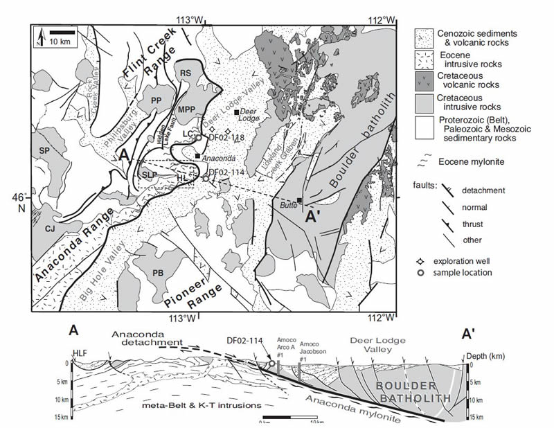
The ranch sits in the Deer Lodge Valley of the Clark Fork River within the greater Northern Rocky Mountains. To the west of the Deer Lodge Valley are the Anaconda and Flint Creek Ranges (seen here in the background). These mountains are composed of Proterozoic, Paleozoic, and Mesozoic sedimentary rocks intruded by Cretaceous and Eocene intrusive and extrusive (volcanic) igneous rocks. Directly at the foot of these mountain ranges is the Anaconda detachment fault. The detachment fault separates the mountains to the west from the Deer Lodge Valley which merges into the mountains to the east.
Geological cross section of the Deer Lodge Valley. The red arrow denotes the approximate location of ranch. Image courtesy of Foster et al., 2010.
The eastern mountains are composed of the Boulder Batholith, which is also the rock that underlies most of the sediment within the valley itself. The Boulder Batholith is a small batholith on the scale of batholiths, but a major gold producer. In general, a batholith is a very large rock that formed from a magma body deep within the Earth. The Boulder Batholith, named after the boulders that occur as the rock breaks down on the surface, is a large granite body that formed from an igneous intrusion 76 million years ago. The intrusion of the magma produced a hydrothermal system, heating up the groundwater and melting the metallic minerals within the area rocks, including the nearby granite. These metallic minerals, now mobile within the water, were then reprecipitated within the older sedimentary and metamorphic rocks of the area surrounding the granite, producing rick metallic ore veins in conjunction with quartz veins. Not only are these Boulder Batholith related rocks rich in gold, but nearby Butte has one of the richest copper producing zones in the world. Mine run off is actually one of the major concerns for the ranch with toxic chemical polluting nearby rivers and streams.
.jpeg)
The valley was formed from similar circumstances as the Basin and Range province to the south and southwest of here. Off the western coast of the US, there was a plate that was subducting (going beneath) North America. That produced compression on the plate and formed the Rocky Mountains. Following the almost complete subduction of the plate the compressional forces on North America were mostly relieved, allowing for the North American plate to expand outwards like a compressed sponge slowly allowed to expand. This expansion process was most noticeable in the Basin and Range province where there are linear mountain ranges alternating with valleys.
.jpeg)
While most of the extensional activity was fairly recent in the Basin and Range province, extensional along the Anaconda Detachment Fault was much older, taking place from 53 to 39 million years ago. This extensional activity forced the Boulder Batholith downwards, while the adjacent mountain ranges moved upwards (in relation). After the downward movement of the valley, sediment started to pile up on the downward block, forming the fertile valley that is present today.
References
http://www.umt.edu/this-is-montana/photos/stories/The%20Boulder%20Batholith.php
http://npshistory.com/publications/grko/nrr-2007-004.pdf
https://pubs.usgs.gov/wsp/1862/report.pdf
Little Bighorn Battlefield National Monument
Visited in 1997
My father and I had visited a lot of national parks on our trip out to Montana from New York. Many of them I have since visited again and taken better pictures, however I haven't been back to this one yet.
.jpg)
The Battle of Little Bighorn lies along the Little Bighorn River, which is within the western edge of the Great Plains region of the US. The ground surface is an undulating terrain created by ridges of the underlying bedrock, ravines, and coulees (small, intermittent streams). The bedrock exposed within the park includes the Upper Cretaceous Age Judith River (~80 to 76 million years old) and Bearpaw Formations (~75 to 70 million years old). The Judith River Formation was deposited along the shoreline of the Western Interior Seaway, which was a body of water that covered much of the middle of North America from the Gulf of Mexico up into Canada during the Cretaceous time period. The Judith River Formation is comprised of sandstones and shales deposited along the shoreline and is one of the major dinosaur fossil bonebeds in the US.
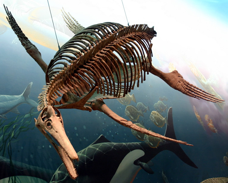
Dolichorhynchops osborni found at Little Bighorn Battlefield, currently located in the Smithsonian National Museum of Natural History. Image courtesy of Wikimedia.
The subsequent Bearpaw Formation (AKA Bearpaw Shale), is a shale layer deposited within the depths of the Western Interior Seaway, when that body of water covered the area. Many ammonites have been found within the Bearpaw Formation as well as a notable plesiosaur within the park. Back in 1977, a routine grave excavation was occurring in Custer National Cemetery and a NPS maintenance employee exhumed pieces of the plesiosaur Dolichorhynchops osborni. After six days of work, a nearly complete vertebral column, a complete pectoral girdle, and complete pelvic girdles were collected by after-hours volunteers and local paleontologists Russell King and Alan Tabrum.
.jpg)
Here is a view from Last Stand Hill that overlooks the floodplain of the Little Bighorn River. The meandering Little Bighorn River floodplain dominates the southwestern edge of the battlefield. The terrain of the battlefield was highly influential in the progression of the battle. The ridges within the landscape offered defensible high grounds for the soldiers of the 7th Cavalry, while the coulees and ravines provided shelter for the advancing Lakota Sioux and Cheyenne warriors.
The markers here, and elsewhere within the park, denote the locations where people had fallen during the battle. The white, marble stones obtained from Italy denote places where Custer's soldiers fell. Where the Native American warriors fell are markers of red granite, although I am not entirely sure of the source of the granite. NPS sources denote it as "Radiant Red" granite from Cold Spring, Montana. However Radiant Red granite comes from Fredericksburg, Texas, while I can't find any granites that are quarried near the town of Cold Spring, Montana. Looking at Radiant Red granite, there are a bazillion names that it can be found under, however the proper geological name is the Town Mountain Granite, that is Proterozoic in age. It is coarse grained, pink to red in color, and contains abundant quartz, plagioclase feldspar, and microcline. The feldspar is what gives the rock its pinkish red hue.
.jpg)
On top of Last Stand Hill is the 7th Calvary Memorial, a monument to all of those who fell during the battle was erected in 1881. The names of all of the soldiers, Indian scouts, and attached personnel who fell on the battlefield are carved into the stone. The monument is composed of granite of unknown type from the Mount Auburn Marble and Granite Works of Cambridge, Massachusetts. Interesting note, an iron fence was added two years after the memorial was erected to keep people from chipping off "souvenirs" of the memorial. The edges were later beveled in 1890 to hide the vandalism and later the fence was removed.
References
https://mrdata.usgs.gov/geology/state/sgmc-unit.php?unit=MTKjr%3B0
https://irma.nps.gov/DataStore/DownloadFile/431897
https://pubs.usgs.gov/wsp/1487/report.pdf
https://www.nps.gov/libi/learn/nature/geology.htm
https://www.nps.gov/libi/learn/nature/fossils.htm
https://pubs.usgs.gov/pp/1561/report.pdf
https://www.history.com/topics/native-american-history/battle-of-the-little-bighorn
https://quarriesandbeyond.org/name_and_origion/r.html
https://commons.wikimedia.org/wiki/File:Dolichorhynchops.jpg
Visited in 1997 and 2010
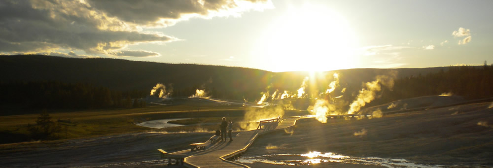
For all of the pictures from Yellowstone National Park be sure to head over to the:
