
South Dakota
![]()

Type |
Symbol |
Year Est. |
|---|---|---|
State Mineral Stone |
Rose Quartz |
1966 |
State Gemstone |
Fairburn Agate |
1966 |
State Fossil |
Triceratops |
1988 |
State Jewelry |
Black Hills Gold |
1988 |
State Mineral Stone: Rose Quartz
Rose Quartz is the pink variety of quartz, which is one of the most common minerals on Earth, primarily due to its simple structure and chemical formula, SiO2. Quartz also has an extremely high hardness, 7 on Mohs hardness scale, meaning that it doesn't scratch very easily and therefore does not break down easily. As the rocks on Earth are slowly eroded over time, most of the other minerals will break down into clay while quartz grains will generally just gets smaller and smaller. The result is that most beach sand is composed of quartz that has a slight hematite (rust) stain to it to give the sand grains their slight yellowish color. Although quartz is a simple mineral, it can come in a variety of colors depending on what type of impurities are present in the crystal structure; pure quartz crystal is clear, milky quartz is white, smoky quartz is grey, amethyst is purple quartz, citrine is yellow quartz, rose quartz is pink, as well as some other colors and varieties. Quartz does not have any cleavage, meaning that when it breaks it doesn't form along perfect surfaces. Instead as the quartz crystals grow, individual mineral molecules of quartz are added to the outside of the crystal from water rich in dissolved SiO2 or mineral melt (liquid rock like lava or magma).
Related: Alabama State Gemstone - Star Blue Quartz; Arkansas State Mineral - Quartz Crystal; Georgia State Gemstone - Quartz; New Hampshire State Gem - Smokey Quartz; South Carolina State Gem Stone - Amethyst
State Gemstone: Fairburn Agate
State Fossil: Triceratops
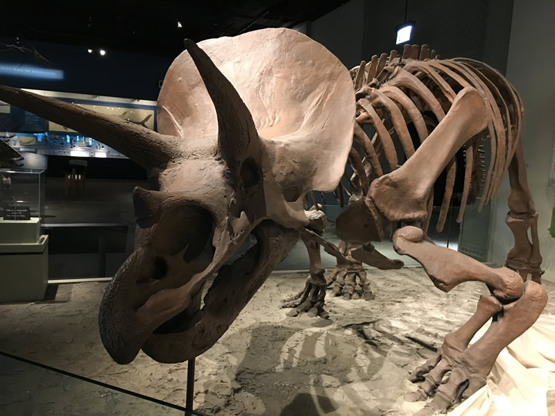
Triceratops horridus skeleton and cast from the Field Museum in Chicago, IL.
The first discovery of material attributed to Triceratops, was in 1887 by George Lyman Cannon near Denver, Colorado, who had found a set of the brow horns attached to a skull roof. He sent the material to O.C. Marsh who, assuming the rock dates were Pliocene, determined that it was from a prehistoric bison, which he named Bison alticornis. However after a more complete specimen was discovered in 1888 from Wyoming's Lance Formation by John Bell Hatcher, as well as a couple of other discoveries, Marsh reevaluated the initial find and eventually added all the finds under a new species, Triceratops, which he named in 1889, meaning "three-horned face".
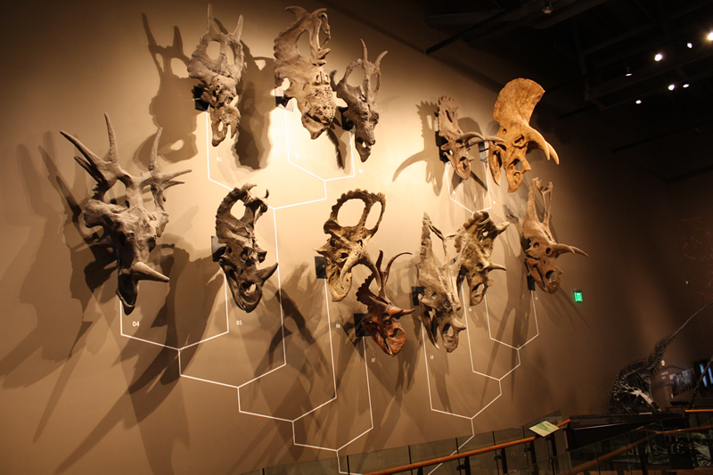
Ceratopsian wall at the Natural History Museum of Utah. Triceratops is the one located in the far right at the top.
Triceratops belongs to a group of animals known as ceratopsians. Ceratopsians were prolific during the Cretaceous, with many different varieties evolving with various numbers of horns and frill adornments. Triceratops was one of the last ceratopsians to have evolved with remains having been found in rocks dating from ~69 million years ago to the end of the dinosaurs ~66 million years ago. It is estimated that Triceratops could grow up to 30 feet in length and weigh 12,000-16,000 pounds. There are currently two recognized species of Triceratops, T. horridus (pictured above in Chicago) and T. prorsus. The skull of Triceratops is one of the largest skulls ever discovered, approaching 10 feet in length in some individuals and not only had the three primary horns (one above each eye and one on the snout), it also had a series of spikes along the edge of the frill known as epoccipitals, and hornlike projects on the jugals (cheekbones). The horns are thought to serve multiple functions, such as defense from predators as well mating display structures.
Related: Wyoming State Dinosaur - Triceratops
State Jewelry: Black Hills Gold
The chemical symbol for gold is Au, and gold is one of the unique minerals that, in its pure form, is composed entirely of one element. It has a hardness of 2.5 to 3 on the Mohs hardness scale meaning that it actually is very soft (your fingernail is 2.5). For this reason most gold jewelry is mixed with another metal to prevent scratching and bending easily. The karat rating of the gold represents it's purity, where 24 karat is 99.9% pure, 22 karat 91.7%, 18 karat 75%, and so on. Gold naturally does not corrode or tarnish, so even when it is mixed with other metals it usually has a resistance to tarnishing, enhancing its value for jewelry. When gold is found in place, the highest grade of gold is often found in association with quartz veins. Currently gold is considered one of the most valuable metals on Earth, being used as the standard for most money (gold standard). Gold is often formed initially in relation to volcanic regions, where fluids associated with volcanoes carry the heavy metals up towards the surface and deposit them in rocks. These are found in areas of current or former subduction zones, places where two plates came together forcing one place down and melting it, while the other plate is forced upwards into mountains. Afterwards, erosion will take the gold out of the mountains and carry them down stream. However, since gold is so dense it does not travel easily down rivers and will often settle to the bottom of the river within the rocks and mud within the river sediment. These gold deposits are known as placer deposits and are the primary place where gold panners find gold. They can then use the locations of these placer deposits to backtrack to the original sources of the gold within the streams.
Related: Alaska State Mineral - Gold; California State Mineral - Gold; North Carolina State Mineral - Gold
References
https://statesymbolsusa.org/states/united-states/south-dakota
https://ninkasibrewing.com/
https://www.gbif.org/species/113684498
https://www.britannica.com/animal/Triceratops
Geology of South Dakota's National Parks
Through Pictures
(at least the one's I have been to)
Minuteman Missile National Historic Site
Mount Rushmore National Memorial
Visited in 1997 and 2021
.jpeg)
Obligatory entrance sign.
The Badlands are a very geological park, where the geology is the focal point of the beauty of the park. Even the term "badlands" is a geological term meaning a landscape made up of generally soft sedimentary rock that erodes easily and has a lot of streams eroding the landscape with little plant life to inhibit the erosion. The main road, Badlands Loop Road, that travels through the park, actually does not cover the vast majority of the park, which is much more difficult to get to. However, there are still a ton of geological sites that can be viewed from the main road. Below is a picture from the visitor's center of the overview of the geological stratigraphic column featuring the main park formations.
.jpeg)
Geological sign from the Badlands NP Visitor's Center
The oldest formation, at the base of the park, is the Pierre Shale. The Pierre Shale is Cretaceous in Age (~75 to 69 million years old) and formed when this area was covered in a vast inland sea known as the Western Interior Seaway. The Pierre Shale covers the lower levels of the landscape towards the northwest of the park, away from the main road. There are some places along the main road that you can see the Pierre Shale, such as at the Pinnacle Overlook, near the western entrance to the park. The shale is at the base of the erosion escarpment here. Within the Pierre Shale, several fossils can be found such as ammonites and mosasaurs. These lived at the same time as the dinosaurs, but since this area was covered in water during the Age of the Dinosaurs, dinosaurs were not to be found.
.jpeg)
View from the Pinnacles Overlook
The yellow layer immediately above the Pierre Shale is known as the Yellow Mounds. It is a weathered extension of the Pierre Shale, that was altered when the Western Interior Seaway went away. Within this layer, which can be plainly seen at the Yellow Mounds Overlook pictured below, a rainforest grew up within the Pierre Shale and converted the upper portions of the shale into a soil, or what is now known as a paleosol (an ancient soil).
.jpeg)
View from Yellow Mounds Overlook
Above the Pierre Shale is the Chadron Formation. The Chadron Formation is Eocene in age (~37 to 34.3 million years old) and was formed along an ancient river floodplain. The Chadron Formation is made up of light gray claystone beds and represent an environment similar to the Everglades today. Fossils found here are alligators, early horses, and the large brontothere (AKA titanothere) mammals. In the above image, the Chadron Formation starts just above the red layer and continue upwards until they hit the layer with multiple horizontal layers within it in the left background. That is our next youngest formation, the Brule Formation.
.jpeg)
Conata Basin Overlook
The Brule Formation is Oligocene in age, deposited 34 to 30 million years ago, and is an interbedded siltstone and sandstone deposit with a lot of clay creating a pale-pink deposit with lots of beds. This was formed when the environment started to dry out from the floodplains of the Chadron Formation and became a savannah with rivers periodically meandering across the environment. Fossils include those of oreodonts, animals related to modern bison and camels, early dogs, and nimravids, animals that looked like saber-toothed tigers but were only distantly related. In the picture above, the Brule Formation can be seen in the upper portion of the outcrop, essentially in line with the fencing on the left side of the photo, and stretching across the view. It is also the entirety of the rock formations in the picture below (the Wild River Valley Overlook) and creates the tops of most of the erosional escarpments seen along the Badlands Loop Roads.
.jpeg)
Wild River Valley Overlook
The youngest rock deposit within Badlands National Park (although there are many younger sediments across the park, this is the final layer within the Badlands escarpment) is the Sharps Formation. The Sharps Formation is an Oligocene Age (30 to 28 million years old) sandstone river channel deposit. This formation can be seen in a few places in the park and is present only at the very top of some of the erosional peaks. Below it can be seen along the Fossil Exhibit Trail as the upper half of that big monolith in the middle of the image. The line about halfway up is the Rockyford Ash layer, a deposit created from a distant volcanic eruption 30 million years ago. The Sharps Formation sits directly on top of the Rockyford Ash Layer.
.jpeg)
Fossil Exhibit Trail outcrop view
This entire region then began to erode away, producing the pinnacles and peaks that we see today. This erosion started around 500,000 years ago as the Cheyenne and White Rivers eroded their way through the landscape. Because all of these rocks are very, very soft, they are eroding at a rate that is much faster than many other landscapes, especially those further west. It is estimated that 1 inch of rock is eroding away every year and that the entire badlands will be gone in the next 500,000 years. This rate is 10,000 times faster than the granitic rocks forming the center of the Black Hills where Mount Rushmore and the Crazy Horse Memorial are located.
.jpeg)
Geological column with the fossils displayed on the Fossil Exhibit Trail
Towards the western end of the Badlands Loop Road is the Fossil Exhibit Trail. The Fossil Exhibit Trail is a wonderful, 0.2 mile "trail", along a boardwalk with bronze exhibits of fossils with displays explaining the animals to whence they belong. As the trailhead sign states, there are seven types of animals displayed along the trail. As the climate changed in the area, each of these animals had to either move, adapt, or extinct. Since it is a loop, the fossils are laid out chronologically. We are going to go backwards through time, starting with the most recent fossils along the trail, and ending with the oldest fossils. You can see a great layout of the stratigraphic section (geology rock layers) and their associated fossils in the image above that was at one of the trailheads for the Fossil Exhibit Trail.
.jpeg)
Oreodont fossil (Leptauchenia) display along Fossil Exhibit Trail
The Oreodont fossil above, Leptauchenia, was found within the Rockyford Ash layer, and Leptauchenia lived from around 32 to 28 million years ago. An oreodont is what is known as an artiodactyl, which is an even-toed hoofed mammal. These include bison, big horned sheep, and camels, of which the camel is the closest living animal to the Leptauchenia.
.jpeg)
Dying to become a fossil exhibit
Along with the fossils, there are also these great displays which shows additional information beside just the fossil. The display attached to the Oreodont fossil is called "Dying to Become a Fossil" and illustrates some of the processes that an animal takes in order to become fossilized.
.jpeg)
Nimravid (Nimravus) fossil display along the Fossil Exhibit Trail
The next fossil is the Nimravid (Nimravus) fossil, which was found in the Brule Formation and lived around 32 to 30 million years ago. Nimravids are animals that resembled saber-toothed cats, of which these cats are only very distantly related. Nimravids fall under the family Nimravidae, as opposed to cats, which are Felidae, however they all fall under the order Carnivora, along with dogs and bears. Some of the differences between Nimravids and true cats is that the nimravid skulls are much shorter than cat skulls and they walked flat footed, as opposed to cats who walk on their toes.
.jpeg)
Fight for Survival
This display, which was paired with the Nimravid skull, displays another aspect of paleontology, taphonomy. This is where paleontologists look at the various aspects of the fossil and try to discern things like how the animal died. In this instance, there is evidence by the hole punctures in the skull of one nimravid, that it was attacked by another one.
.jpeg)
Dog (Hesperocyon) fossil exhibit along the Fossil Exhibit Trail
This dog fossil (Hesperocyon) is an early ancestor to modern day dogs and was also found in the Brule Formation. This dog lived around 37 to 28 million years ago.
.jpeg)
It's a Dog's Life
Associated with the Hesperocyon display is the "It's a Dog's Life" display, showing the eventual evolution of the Hesperocyon into modern day dogs as we know them.
.jpeg)
An early horse, Mesohippus, display fossil on the Fossil Exhibit Trail
Next up on the Fossil Exhibit Trail is the Mesohippus, an early ancestor to modern day horses. Unlike modern day horses, who only have one toe, Mesohippus had three toes. Mesohippus lived from 37to 30 million years ago and this fossil was found within the Chadron Formation.
.jpeg)
Off to the races
Alongside the Mesohippus display is "Off to the Races", a paleontological display discussing adaptation. Mesohippus's adaptation was the reduction of digits in it's foot from 5 toes, seen in earlier ancestorial horses, to the three toes in Mesohippus, that will eventually evolve into the one toe of modern-day horses.
.jpeg)
Alligator fossil along the Fossil Exhibit Trail
The next fossil is that of an alligator skull, which lived in the region from 34 to 37 million years ago. This fossil was found within the Chadron Formation.
.jpeg)
See Yea Later, Alligator
The associated sign with the Alligator skull discusses the size disparity between ancient alligators and their modern day descendants. As can be seen with the above skull, modern day alligators are much larger, over twice as long in fact, than this ancestor.
.jpeg)
Titanothere (Megacerops) lower jaw fossil exhibit from the Fossil Exhibit Trail
Titanotheres, also known as brontotheres, are very large hoofed mammals that evolved during the Eocene (~50 million years ago) and later went extinct in the Oligocene (~28 million years ago). They lived in Asia and North America and several well known species can be found across rocks of western North America. This Megacerops lower jaw fossil was found within the Chadron Formation, just above the Yellow Mounds layer. They lived in this area from 34 to 37 million years ago.
.jpeg)
Titanic Discovery
The associated sign with the titanothere fossil discusses the process of early field work, where paleontologists go out into the field and dig out the fossils, often with the aid of knowledgeable locals, who initially find the fossils eroding out of the landscape.
.jpeg)
Ammonite (Placenticeras) fossil exhibit along the Fossil Exhibit Trail
The final fossil on the Fossil Exhibit Trail (or the first, if you went in the opposite direction than I did), and the only fossil that isn't of a vertebrate, is the ammonite fossil Placenticeras. Ammonites are ancient relatives to octopi, squids, and nautiloids. This fossil, since it is the only marine fossil, was found in the only marine deposits, the Pierre Shale, located at the base of the rocks within the park. Ammonites lived within this area from 75 to 67 million years ago, before going extinct shortly thereafter 65.5 million years ago.
.jpeg)
Under the Sea
The associated sign with the ammonite fossil is "Under the Sea", that describes that throughout time the environmental conditions have changed. What is now the badlands, was once under water during the Cretaceous within the Western Interior Seaway.
.jpeg)
A display of several fossils found within the Badlands National Park at the Ben Reifel Visitor Center.
At the eastern end of the Badlands Loop Road is the Ben Reifel Visitor Center, and here there are several actual fossil exhibits, as opposed to the "fossils" on the Fossil Exhibit Trail which are clearly casts designed to weather the elements and visitors. The above display shows fossils from the Brule Formation. These include a Subhyracodon skull (top of picture), which was a hornless rhinoceros, a Leptomeryx, a small deer-like animal, (top right), and the Archaeotherium (large fossil on the bottom). The Archaeotherium was a "big pig", that although looked like a pig was only a distant relation to modern day pigs and was more closely related to hippos.
.jpeg)
A display of more fossils found within the Badlands National Park at the Ben Reifel Visitor Center.
The above shows another collection of fossils from within the park. These were found within several of the rock formations. This includes a titanothere femur and skull, an alligator skull, and a tortoise. There are also several more fossil exhibits within the visitor's center and it is a stop well worth taking your time in.
References
https://irma.nps.gov/DataStore/Reference/Profile/2251588
https://www.nps.gov/badl/index.htm
https://www.nps.gov/articles/000/badl-geologic-formations.htm https://ngmdb.usgs.gov/Geolex/UnitRefs/BruleRefs_7360.html
https://www.nps.gov/articles/000/oreodont.htm
https://www.nps.gov/articles/000/nimravid.htm
https://www.britannica.com/animal/titanothere
https://www.nps.gov/articles/000/big-pig-dig.htm
Minuteman Missile National Historic Site
Visited in 2021
.jpeg)
Obligatory entrance sign photo
Minuteman Missile National Historic Site protects two locations (plus the Visitor's Center), as representatives of the once sprawling Minuteman Missile field that covered the far western portion of South Dakota. In total, there were 15 Launch Control Facilities and 150 Missile Silos the held the Minuteman Intercontinental Ballistic Missiles. The two locations preserved are one of the Launch Control Facilities, Delta-01, and the corresponding Missile Sile (Launch Facility), Delta-09. Delta-01 was only accessible via a tour, and since we were pressed for time, we only visited Delta-09 and the Visitor's Center.
.jpeg)
The Minuteman Missile Silo Delta-09 sits within the American Great Plains, a expansive region with little topography. However, the site here does sit very close to the Badlands National Park just to the south. Per the National Park's page:
Landforms in the Great Plains are unglaciated and retain soils formed by shallow seas that covered the region approximately seventy-five million years ago.... The seas that once covered South Dakota's Western Plains deposited limestone and sandstone overlain by soft Pierre shale.
.jpeg)
Looking at the missile silo cap at Delta-09
The geological description of the park is a little simplistic, however there is not much that can be discerned from other online sources. They even state in their combined Historic Structures Report, Cultural Landscape Report, and Environmental Assessment report, which often contains geological information on many of the parks within the NPS, that since any proposed work would not disturb the bedrock that "further analysis of geology will be dismissed". So while they have no intention of getting into the geology of the site, if we look back into the original structure, the missile silo was obviously dug into the geological layers of the region.
.jpeg)
Looking down at the now defunct missile, within Missile Silo Delta-09
The missile silo itself is 12 feet in diameter and 80 feet deep. You can take a look down it, as seen above, when visiting the site. The Visitor's Center also has the nice diagram below, however, it also is lacking in geological context.
.jpeg)
Diagram of the Delta-09 Missile Silo
Looking at a geological map of the region does elucidate some of the geology. The map below shows a snippet of the regional geology map with a close up view of the geology of the Delta-09 site, marked by the "X". Delta-09 sits within the Qe deposit. This is wind blown sand (eolian), that dates back to the Eocene (~34 million years old). This sand is far younger than the denoted Pierre Shale at 75 million years old listed on the website. The sand here is predominantly wind blown sediment that is reworked sands from the older rocks below.
.PNG)
Snippet of the Delta-09 Geology Map. Full map courtesy of the National Geologic Map Database.
On the map to the south of the Delta-09 site, you can see a different, darker shade of orange, Qoa. Qoa, the Older Alluvium, represents a different form of Eocene deposit that also formed from the reworking of even older rocks, soils, and sediments. Both of these "Q" (Quaternary), layers sit upon the thicker bedrock of the region. However, through the Qoa deposit, we can catch a glimpse of some of the true bedrock of the region. The description of the geological layers to the right of the map lists them in reverse chronological order. This means that the oldest layers are located at the bottom of the legend, with progressively younger layers stacked on top. The Pierre Shale is indeed the oldest, and thickest, bedrock layer within this region and although it only peaks out a little bit in the area of Delta-09, it is definitely a major rock unit below the surface. The Pierre Shale is Cretaceous in Age (~75 to 69 million years old) and formed when this area, and much of central North America, was covered in a vast inland sea known as the Western Interior Seaway. Within the Pierre Shale, several fossils can be found in nearby Badlands National Park, such as ammonites and mosasaurs. These lived at the same time as the dinosaurs, but since this area was covered in water during the Age of the Dinosaurs, dinosaurs were not to be found.
.jpeg)
The next rock unit above the Pierre Shale within this region, and likely can be found along the walls of the missile silo, is the Chadron Formation. The Chadron Formation is Eocene in age (~37 to 34.3 million years old) and was formed along an ancient river floodplain. The Chadron Formation is made up of light gray claystone beds and represent an environment similar to the Everglades today. Fossils that can be found within Badlands NP within the Chadron are alligators, early horses, and the large brontothere (AKA titanothere) mammals. Within this area though, the Chadron Formation is likely a thin layer, especially compared to the outcropping within Badlands NP.
References
https://ngmdb.usgs.gov/Prodesc/proddesc_9826.htm
https://www.nps.gov/mimi/learn/nature/index.htm
https://npshistory.com/publications/mimi/hsr-clr-ea.pdf
https://www.nps.gov/articles/000/badl-geologic-formations.htm
Mount Rushmore National Memorial
Visited in 1997 and 2021
.jpg)
Obligatory entrance sign photo.
.png)
Geological map of the Black Hills, including Mount Rushmore (noted just below the slice through the map). Image courtesy of the NPS.
Mount Rushmore is set within a large geologic dome. This is a region where all of the land is bowed upwards, like an overturned bowl. After erosion, the result is a bullseye pattern of rocks, where the oldest rocks are in the center of the bullseye and progressively get younger towards the outside.
.png)
Thuŋkášila Šákpe, AKA Mount Rushmore, before being carved. Image courtesy of nativehope.org.
Although this could be considered outside the normal realm of geology, I do want to note that before being known as Mount Rushmore, the Lakota referred to the mountain as Thuŋkášila Šákpe, Lakota for The Six Grandfathers. The mountain named by Lakota medicine man Nicolas Black Elk after seeing a vision “... of the six sacred directions: west, east, north, south, above, and below. The directions were said to represent kindness and love, full of years and wisdom, like human grandfathers.”
.jpeg)
As you drive up to the main entrance looking northeast, you first pass the profile view of Washington. From this direction you get a good view of the mountain sans most of the demolition work that was done with the carvings. You can see what would be the normally weathered surface of the granite before the carving brings out the fresh surface. This surface is also more reminiscent of the uncarved mountain seen in the image above. About 1.6 billion years ago, during the Proterozoic, magma began to work its way up through the rocks in this area. While still well below the surface of the earth, that magma cooled slowly to form the granite that makes up the carving stone for Mount Rushmore. This rock unit is known as the Harney Peak Granite.
.jpeg)
While the magma was cooling, it cooled unevenly. This caused some portions of the rock to cool quickly, producing smaller, fine-grained, crystals, while other parts of the granite cooled more slowly with very large grained crystals. These large grained crystal granites are known as pegmatites. The upper portion of Mount Rushmore is comprised mostly of the fine grained crystal variety, which is an easier rock to carve from. This large body of magma is known as a batholith.
.jpeg)
Between the formation of the granite 1.6 billion years ago and 500 million years ago, new rocks were deposited and eroded on top of the Harney Peak Granite batholith. However, due to the extreme hardness of the granite, the Harney Peak Granite remained behind while these other rocks had been lost to erosion and time. After this period of time, between 500 and 100 million years ago, there were some rocks deposited from which we do have remains of. Immediately on top of the granite is the green rock seen in the geological map above. This green rock, titled the "limestone plateau" on the map, can be seen surrounding the central granite bullseye. The "limestone plateau" is made up of several different rock layers and is discussed in more detail in the Wind Cave National Park listing (since that is where Wind Cave is located). After deposition of these rocks, the whole region started to be uplifted around 70 million years ago. This uplift is related to the uplifts seen across the Rocky Mountains at the same time.
.png)
Google Earth image of the Black Hill dome.
The uplift formed the dome that we had discussed above. This dome is easily noticeable in the aerial image of the region as well, as seen in the Google Earth Image above. This dome structure stretches across South Dakota and Wyoming, even up to the area in which Devils Tower is located.
.gif)
Cross section of the Black Hills. Image courtesy of A Textbook of Geology.
In geological terms, a dome is an anticlinal structure where the rocks dip gently away from the center in all directions. After folding, fracturing, and faulting, this causes the overlying rocks to break apart in the middle, allowing for easier erosion of the them. Once these younger rocks have eroded away, the older rocks are exposed with the oldest rocks exposed in the center. As before, due to the extreme hardness of the Harney Peak Granite, they withstood erosion and remained around much longer. Their hardness is also why the Black Hills have these granitic mountain peaks that have not eroded away.
.jpeg)
As you walk up to the main entrance to the main viewing platform, you come across a rather more grand entrance sign than the wooden one at the park entrance. Another interesting decision that was made for the refurbishment of the memorial in the 1980's and 1990's was the inclusion of several areas encased with granitic blocks. These granitic blocks are found within the Visitor’s & Interpretive Center, the Avenue of Flags, and Grand View Terrace, which, while they are granite, are not the Harney Peak Granite of the mountain. These granitic blocks were trucked in from elsewhere.
.jpeg)
Here you can see the granitic blocks in the framing of the memorial at the distal end of the Avenue of Flags. In construction terms, these granitic rocks are known as "Rockville Beige granite" and are from the quarry company Coldspring. Quarried from Rockville, MN, this granite is more commonly known in geology as the Rockville Granite.
.jpeg)
Closeup of the Rockville Granite at Mount Rushmore
Known for its very large mineral crystals and minimal amount of metamorphism, the Rockville Granite presents as a very nice, consistent granite comprised mainly of quartz, feldspar, biotite, and hornblende with other accessory and background minerals. Minnesota has several granitic bodies that all date to around the same age. The Rockville Granite in particular is dated to being 1.812 billion years old (Ga), which is considered the Late Penokean of the Paleoproterozoic Era. When compared to the varying cooling rates of the Harney Peak Granite producing varying textures with metamorphic inclusions throughout, it is no wonder whey they decided to use a more picturesque granitic rock for the entrance and viewing terrace.
References
https://www.nps.gov/moru/learn/nature/geologicactivity.htm
https://www.govinfo.gov/content/pkg/GOVPUB-I29-PURL-gpo79412/pdf/GOVPUB-I29-PURL-gpo79412.pdf
https://blog.nativehope.org/six-grandfathers-before-it-was-known-as-mount-rushmore
https://etc.usf.edu/clipart/63000/63044/63044_black_hills.htm
https://coldspringusa.com/products/rockville-beige/
https://coldspringusa.com/case_study/mount-rushmore/#!
https://msaweb.org/AmMin/AM24/AM24_303.pdf
https://conservancy.umn.edu/server/api/core/bitstreams/cc610018-1b5b-431a-97ff-fbb4a9b67777/content
Visited in 2021
.jpg)
Obligatory entrance sign
Geological map of the Black Hills, including Wind Cave National Park (noted just below the southernmost point of the purple rocks). Image courtesy of the NPS.
Like the Mount Rushmore National Memorial and the Crazy Horse Memorial, Wind Cave National Park is located within the Black Hills dome. But unlike those parks, Wind Cave National Park is not located within the Harney Peak Granite. The rocks in this region started forming about 1.6 billion years ago, during the Proterozoic. This is when magma began to work its way up through the surrounding rocks in this area at the time. While still well below the surface of the earth, that magma cooled slowly to form the Harney Peak Granite. Due to the hardness of the granite, from its formation at 1.6 billion years to about 500 million years ago, several rocks formations were likely deposited on top of it and then eroded away leaving no trace. However, starting around 500 million years ago, new rocks that were deposited on the Harney Peak Granite have been preserved. These rocks include the green "Limestone Plateau" rocks as pictured in the map above.
.png)
Geological map of Wind Cave National Park. Map courtesy of the NPS.
.JPG)
Legend for the Wind Cave NP Geological Map. Image courtesy of the NPS.
The "Limestone Plateau" can be subdivided into numerous different rock formations, once we zoom in on the part of the dome within Wind Cave National Park. Deposited directly on top of the Harney Peak Granite is the Ordovician Age Deadwood Formation (~480 million years old). This is a mixture of sandstones and limestones, as well as some other rocks, that represent a transgression, where the sea level started to rise and the oceans started to cover this region. On top of that is the Mississippian Age Englewood Limestone (~ 363 –358 million years old). The Englewood represents a shallow marine environment.
.jpeg)
On top of the Englewood Formation is the primary rock of interest for Wind Cave National Park, the Pahasapa Limestone (AKA Madison Limestone). This is a Mississippian Age limestone that dates to about 358 to 341 million years old. This is the limestone from which Wind Cave is formed within. The Pahasapa Limestone is up to 420 feet thick and formed from the deposition of seashell fragments within a warm shallow sea across the region. Following deposition of the Pahasapa Limestone, the seas started to recede away ~320 million years ago. This is when the first parts of Wind Cave started to form.
When the seas started to come back, (~300 million years ago) rocks were deposited on top of the Pahasapa Limestone. This time they were made up of limestones, sandstones, and red clay shales. This formation, called the Minnelusa Formation, created a semi-permeable barrier on top of the Pahasapa, limiting water flow down through the rock from the surface. An interesting thing to note is that the Minnelusa Formation can actually also be seen within Wind Cave as well, with some of the red clay visible in higher parts of the cave near the Garden of Eden and Fairgrounds rooms. The inclusion of the Minnelusa Formation within Wind Cave is how scientists know that the cave started forming over 300 million years ago, making it one of the oldest known cave systems in the world. Following deposition of the Minnelusa Formation, sea levels continued to rise and fall, slowing dissolving out the cavern system. This transgression-regression cycle of the seas continued until around 70 million years ago when the entire area started to be uplifted into the Black Hills dome. As the dome was being uplifted, fracturing of the rocks allowing more water to flow through the rocks, quickening the pace of cave formation.
Cross section of the Black Hills. Image courtesy of A Textbook of Geology.
In geological terms, a dome is an anticlinal structure where the rocks dip gently away from the center in all directions. After folding, fracturing, and faulting, this causes the overlying rocks to break apart in the middle, allowing for easier erosion of the them. Once these younger rocks have eroded away, the older rocks are exposed with the oldest rocks exposed in the center. As before, due to the extreme hardness of the Harney Peak Granite, they withstood erosion and remained around much longer. Their hardness is also why the Black Hills have these granitic mountain peaks that have not eroded away.
.jpeg)
Most limestones are comprised primarily of the mineral calcite, which is a variety of calcium carbonate (CaCO3). Calcite is the mineral that most sea shells are made out of. Calcite has a physical property that it will dissolve in slightly acid waters, which is where you get the formations of caves. One of the unique properties of the Pahasapa Limestone though, is that when it formed, it had significant quantities of gypsum, another type of mineral, within the rock. Gypsum (CaSO4) has the ability to absorb large quantities of water, and when it does so it, expands and then contracts when that water is expelled. Over time, as water entered and left the limestone, the gypsum expanded and contracted, fracturing the surrounding rocks. As time progressed, the water that flowed through these fractures within the limestone slowly started to replace the gypsum with calcite.
.jpeg)
Boxwork Formations
Geologically speaking, Wind Cave is most well known for its boxwork speleothems (cave formations) (as seen in the image above). The boxwork is a result of these gypsum fractures that were refilled with calcite. The calcite crystals that filled in the fractures were more resistant to dissolution than the surrounding limestone was, so as the limestone rock dissolved away, revealing the cave, the calcite crystals that filled the gypsum fractures remained behind. These calcite crystals are what primarily form the boxwork speleothems. The fracture pattern, and therefore the speleothem pattern, forms a very angular, boxy configuration, giving the speleothems the term boxwork.
.jpg)
Map of Wind Cave
Even looking at a map of the cave itself, it also forms an angular and boxy configuration, producing a fractal pattern (where a pattern is repeated over different scales). Overall, the cave descends 643 feet and extends over 167 miles (as of 2024). As the dome was uplifted, the water started to drain out of the cave about 40 to 50 million years ago. The current day water levels are located about 500 feet below the surface in an area of the cave known as "the Lakes".
.jpeg)
Although the most well know, boxwork isn't the only cave formation within Wind Cave. There are other formations such as popcorn ceiling and frostwork. However, formations such as flowstones and dripstones, like stalactites and stalagmites, are more rare here due to the drier climate and the semi-permeable Minnelusa Formation overlying the cave that limits the amount of water flowing through.
References
https://irma.nps.gov/DataStore/DownloadFile/598161
https://www.nps.gov/moru/learn/nature/geologicactivity.htm
https://commons.und.edu/theses/5/
https://ngmdb.usgs.gov/Geolex/UnitRefs/EnglewoodRefs_7638.html
https://sd-aipg.org/wp-content/uploads/2024/10/geologicroadsignrt16.pdf
https://www.nps.gov/wica/learn/nature/wind-cave-geology.htm
https://etc.usf.edu/clipart/63000/63044/63044_black_hills.htm
https://npshistory.com/publications/wica/cave-karst-rmp-2007.pdf