
Wyoming
![]()

Type |
Symbol |
Year Est. |
|---|---|---|
State Gemstone |
Jade |
1967 |
State Fossil |
Knightia |
1987 |
State Dinosaur |
Triceratops |
1994 |
State Gemstone: Jade
Jade is a green gemstone that has a bit of an ambiguous mineralogy. It turns out that samples of gemstones that have been called jade actually fall into three different mineral categories. Typically what happens with gemstones, is that they are a name of a specific colored mineral; i.e. purple quartz is known as amethyst. Well in this instance the green gemstone jade can be one of three minerals: jadeite, actinolite, or tremolite. And even the combination of actinolite and tremolite goes by a different name: nephrite. There is a strong physical similarity between all these minerals, hence the confusion of which mineral jade could belong to and so all of these, as long as they are green, can be considered jade. All of these minerals have a hardness of 6 to 7 on Mohs Hardness Scale and all are silicates, although with significantly different chemical formulas. Jadeite is a aluminum-rich pyroxene (NaAlSi2O6) and actinolite and tremolite are magnesium-rich amphiboles (Ca2(Mg,Fe)5Si8O22(OH)2). All three of these minerals are formed through the process of metamorphism. Jadeite is a metamorphosed variety of albite, a plagioclase mineral and actinolite/tremolite are commonly formed from the metamorphism of ultramafic and mafic igneous rocks, such as those formed in oceanic crust. Due to the durability of the jade minerals, they can be formed into tools, however the green color has caused many artisans to use them more for jewelry and sculptures.
Related: Alaska State Gemstone - Jade
State Fossil: Knightia
State Dinosaur: Triceratops
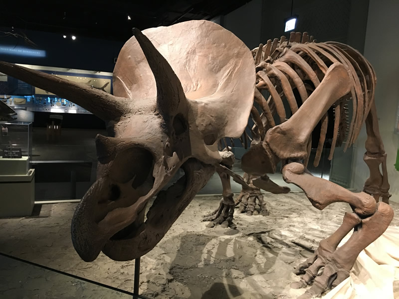
Triceratops horridus skeleton and cast from the Field Museum in Chicago, IL.
The first discovery of material attributed to Triceratops, was in 1887 by George Lyman Cannon near Denver, Colorado, who had found a set of the brow horns attached to a skull roof. He sent the material to O.C. Marsh who, assuming the rock dates were Pliocene, determined that it was from a prehistoric bison, which he named Bison alticornis. However after a more complete specimen was discovered in 1888 from Wyoming's Lance Formation by John Bell Hatcher, as well as a couple of other discoveries, Marsh reevaluated the initial find and eventually added all the finds under a new species, Triceratops, which he named in 1889, meaning "three-horned face".
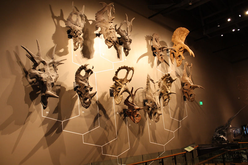
Ceratopsian wall at the Natural History Museum of Utah. Triceratops is the one located in the far right at the top.
Triceratops belongs to a group of animals known as ceratopsians. Ceratopsians were prolific during the Cretaceous, with many different varieties evolving with various numbers of horns and frill adornments. Triceratops was one of the last ceratopsians to have evolved with remains having been found in rocks dating from ~69 million years ago to the end of the dinosaurs ~66 million years ago. It is estimated that Triceratops could grow up to 30 feet in length and weigh 12,000-16,000 pounds. There are currently two recognized species of Triceratops, T. horridus (pictured above in Chicago) and T. prorsus. The skull of Triceratops is one of the largest skulls ever discovered, approaching 10 feet in length in some individuals and not only had the three primary horns (one above each eye and one on the snout), it also had a series of spikes along the edge of the frill known as epoccipitals, and hornlike projects on the jugals (cheekbones). The horns are thought to serve multiple functions, such as defense from predators as well mating display structures.
Related: South Dakota State Fossil - Triceratops
References
https://statesymbolsusa.org/states/united-states/wyoming
https://ninkasibrewing.com/
https://www.gbif.org/species/113684498
https://www.britannica.com/animal/Triceratops
Geology of Wyoming's National Parks
Through Pictures
(at least the one's I have been to)
Bighorn Canyon National Recreation Area
Devils Tower National Monument
Fossil Butte National Monument
John D. Rockefeller, Jr. Memorial Parkway
Bighorn Canyon National Recreation Area
Visited in 2021

For all of the pictures from Bighorn Canyon National Recreation Area be sure to head over to the:
Devils Tower National Monument
Visited in 1997 and 2021
.jpeg)
Obligatory entrance sign shot, however this is probably one of my favorite alignments of the sign to the feature of the park.
.jpeg)
While describing the geology of Devils Tower you would probably want to start with the tower first (duh). However, in order to understand how the tower formed, you need to understand the rocks that were here before the tower, or what would become the tower, some of which still remain.
.jpeg)
While many of the rocks that Devils Tower formed within have long since eroded away, there are still significant amounts of older rocks that the tower currently resides on. You can see some of these rocks as you drive up to the tower from the main entrance (photo with the entrance sign and directly above).
.png)
Geology of the Devils Tower sedimentary rocks. Image courtesy of NPS.
The bright red rocks at the base of the hillside are the Spearfish Formation, which can be seen most easily in the photo above without the entrance sign. These rocks, dark red sandstones and maroon siltstones, formed during the Permian and Triassic Periods (~ 225 to 195 million years ago) when this area was covered by a shallow inland sea. The deep red color is from the oxidation (rusting) of iron within the deposits. After the Triassic Period, during the Middle Jurassic (~170 million years ago), the inland seas periodically withdrew producing periods of evaporation. This evaporation lefts gypsum rich deposits in the form of the Gypsum Springs Formation.
.jpeg)
View facing away from the tower. You can see the Spearfish Formation in the distance towards the let half of the photo.
Afterwards, the Middle Jurassic (~165 million years old) Stockade Beaver Shale then represents the deepening of the inland seas, with the shales deposited in deeper waters than the previous Spearfish Formation. The final sedimentary deposits that remain within the park are the Late Jurassic (~155 million years old) coastal dunes and beach deposits of the Hulett Sandstone. Within these rocks that form the cliff edge surrounding the tower, ripples from the former beaches can still be seen.
.jpeg)
The formation of the tower itself is uncertain though. There are several theories that have been proposed with none, to date, taking precedence. It is without a doubt that the tower formed from some variety of magmatic intrusion within the surrounding sedimentary rocks one to two miles below the (former) surface that began about 50 million years ago. This magma then cooled and solidified, forming the basis of the tower itself. Then, around 5 to 10 million years ago, the overriding sedimentary rocks started to erode away and expose the tower, leaving behind the much more resistant rocks.
.jpeg)
- Igneous stock. The magma intruded into the sedimentary rock layers forming a body roughly the shape of the modern day tower. The magma then cooled, and eventually the overriding sedimentary rocks eroded away, along the outer edges of the igneous body for the last several million years.
- Laccolith. This is a larger igneous intrusion with a more mushroom shape to it. Again, the magma solidified and then eroded away once the overlying sediment was removed and eventually eroded down to the tower shape as we know it today.
- Volcanic plug. Essentially this was the root of a volcano, where magma was rising up through the volcano and eventually as the volcano went extinct, the magma within the volcano solidified. This is deeper within the earth than what is known as a "volcanic neck". The volcanic neck theory is discussed below.
- Maar-diatreme volcano. This is the most recent suggestion where the magma caused the groundwater to become superheated and eventually explode, creating a crater. The crater was then filled with magma and solidified. Eventually the surrounding rocks eroded away, again, leaving the tower as we see it today.
.jpeg)
The rock itself is what is known as a phonolite porphyry. Phonolite is a type of igneous rock that is rich in alkali feldspar and moderate amounts of silica (quartz). As you can see in the diagram below, phonolite has one of the highest percentages of alkali feldspar. The alkali feldspar in this instance is orthoclase, which makes up the second part of the rock name - porphyry. Porphyry, AKA porphyritic rocks, are rocks composed of two principle grain sizes, a background, where the mineral crystals are usually indistinguishable, and the much larger crystals, known as phenocrysts. In the photo above, orthoclase is the mineral that makes up the phenocrysts, the large white crystals on a background that is more grey in color.
.png)
Igneous rock diagram. Image courtesy of Moayyed et al., 2008.
But one of the most distinguishable factors of the tower, besides its size amongst a fairly featureless plain, is the columnar jointing. Columnar jointing is what produces those vertical lines seen at a distance of the tower. These columns are roughly hexagonal in shape, however they are not consistent and Devils Tower has many that are pentagonal columns as well, as well as ranging in diameter from 10 feet across to 4 feet across. These columns are formed when the igneous body (magma) is cooling and the magma starts to shrink (contract). This contracting produces stress lines which radiate out through the resulting rock, forming this columnar jointing pattern. These joint lines align perpendicularly to the direction of the cooling front. Since the jointing lines are running vertical, it can be assumed that the cooling front was essentially horizontal above the tower. With the fractures running vertically through the height of the tower, boulders breaking off and forming a pile of boulders, the scree, are fairly common, especially through geological history.
.jpeg)
One other theory of the tower's formation is that of a volcanic neck. A volcanic neck is related to the volcanic plug, however a neck would be seen as the central portion of a volcano, as opposed to deep within the earth. In this instance, if this were a volcanic neck, what we would see is that Devils Tower is the core of the volcano, with the sloped sides having been eroded away. However, the jointing pattern, which runs vertically and curves towards the bottom of the tower, indicates that this theory of a volcanic neck is incorrect. If this were a former volcanic neck, the jointing pattern would run towards the center of the tower, as opposed to running nearly vertical.
References
https://www.nps.gov/deto/learn/nature/geologicformations.htm
https://www.nps.gov/deto/learn/nature/tower-formation.htm
https://www.nps.gov/places/spearfish-and-inyan-kara.htm
https://ngmdb.usgs.gov/Geolex/UnitRefs/HulettRefs_8580.htm
https://www.science.org/doi/10.1126/science.134.3487.1373
https://www.britannica.com/science/phonolite
https://www.geowyo.com/devils-tower--black-hills.html
https://ngmdb.usgs.gov/Geolex/UnitRefs/StockadeBeaverRefs_10594.html
https://npshistory.com/publications/deto/brochures/geology-2017.pdf
https://www.sciencedirect.com/science/article/abs/pii/S0009281906000225
Fossil Butte National Monument
Visited in 2013
.jpg)
The obligatory entrance sign.
.jpg)
Since the park is a fossil based park, and most fossils you can't see in their "natural habitat", the best places to see the local fossils are in the visitor centers of these parks. Here we have a fossil wall of some of the spectacular fish fossils found.
.jpg)
Many of the fossil plants found in the park.
.jpg)
A crocodilian skeleton.
.jpg)
Some local turtle fossils.
.jpg)
Vertebrate fossils like lizards, bats, and a tiny early horse.
.jpg)
Panoramic view of the park from one of the highest points along the main drive.
.jpg)
First view of the Historic Quarry as we hiked up to it.
.jpg)
Up close view of the Historic Quarry as you come up on it from the main trail. The Historic Quarry is located within the Green River Formation of the Eocene. The Green River Formation is a prehistoric lake deposit from a lake known as Fossil Lake. In these deposits each layer of sediment within the rocks represents sediment that was slowly deposited over time, likely with one layer representing one year of deposition, with winter time freezing over the lake and halting deposition.
.jpg)
Me in front of the quarry.
.jpg)
View of the further side of the Historic Quarry where the trail switchbacks up to the upper layers.
.jpg)
View of some of the main fossil bearing units in the upper portion of the Historic Quarry. You can see the individual laminae pretty well from here.
.jpg)
Panoramic view of the valley standing at the Historic Quarry
.jpg)
A highlight of where to find some fossils among the many laminae of the prehistoric lake bed.
.jpg)
Entering the old fossil hunter's home.
Visited in 2010 and 2021

Obligatory entrance sign photo. This specific photo however is from our first trip there in 2010.

Geological stratigraphic column of the Teton Range within Grand Teton National Park. Image courtesy of the USGS.
The rocks that form the Teton Range, the mountains that make up the central focus of Grand Teton NP, date back hundreds of millions to billions of years. The oldest rocks within the part, at the bottom of the stratigraphic column, are 2.7 billion year old (Ga) gneiss. These were formed from the metamorphism of seafloor sediments and volcanic debris caught within a continental collision.

View of the mountains towards the southern entrance near Jackson Hole, WY.
After the metamorphism of the gneiss, the rocks were infiltrated by magma bodies 2.5 billion years ago. These magma bodies slowly cooled forming the granites that top many of the mountains within the park including Grand Teton, Middle Teton, and Mount Owen. These mountains (pictured below and maybe above if the clouds weren't covering the peaks) form the middle part of Grand Teton National Park.

Me in front of Grand Teton (the prominent point in the middle), Middle Teton (I believe the sheltered point to the left), and Mount Owen (the short point to the right of Grand Teton) along the Taggart Lake Trail.
The last of the basement rocks formed 775 million years ago (Ma) when the region started to stretch, resulting in cracks running through the gneiss and granites. Basaltic magma flowed upwards through the cracks and cooled forming dikes of an igneous rock known as diabase.

Along the shores of Jenny Lake.
After the formation of the igneous and metamorphic bedrocks, sea level rose and allowed for the deposition of a suite of sedimentary rocks starting with beach sands (the Flathead Sandstone at 510 Ma), then deeper water mudstones and limestones. While that was the origin of the rocks within the mountains, we now get to the formation of the mountains themselves.

This great geological history diagram of the Tetons is located along the shores of Jenny Lake.
As shown in the geological diagram above, the region that became the Teton Mountains started to expand yet again. This expansion started around 10 million years ago and created the Teton Fault, a normal fault.

A normal fault
This relatively young age for the mountains makes them far younger than the nearby Rockies, which started to be formed 50 to 80 million years ago. Like the nearby Wasatch Mountains in Utah, the extensional forces that formed the Teton Mountains are related to the extensional pressures from the Basin and Range expansion.

Extensional activity in the Basin and Range Province. Image courtesy of Miracosta.edu.
What happens in this type of expansion is that while the blocks of crust are being pulled apart, they start to rotate. This rotation is what produces the mountain peaks. Think of a row of blocks all sitting next to each other, then rotate each of them on their corner so that you have a corner sticking up, that is your mountains. The "V" that is formed between the mountains is your valleys, or basins, which begin to fill up with eroded sediment from the new mountains. These areas become nice flat plains in relation to the nearby jagged peaks. The mountains are still being uplifted through this process. Overall, the blocks have moved almost 30,000 feet along the Teton Fault and continue to move with each earthquake.

Glacial boulders in Taggart Creek along the Taggart Lake Trail.
While the mountains are built up, erosion wears them down. There is erosion through water activity, like rain and streams, but also glacial activity. While water erosion can carve out phenomenal features over time, it has a tendency to smooth over landscape features. Glaciers on the other hand have a tendency to produce jagged, awe-inspiring landscape features. Many of the striking landscapes were formed during the last few glacial events over the previous 2 million years. Glacial erosion carved out many of the valleys within the Tetons from their "V" shaped stream profile to a "U" shaped valley, and also dug out many of the lakes within the park. Jackson Lake, by far the largest lake in the park, is over 400 feet deep carved out during the Pinedale glacial period 50,000 to 14,000 years ago.

Jackson Lake
After the glaciers eroded the mountains and carried their debris down, the material was deposited along the flanks of the mountains in piles known as moraines. Hiking up the lower slopes of the Tetons brings you through these glacial deposits where you can see many boulders such as seen along the Taggart Lake Trail above.

Glacial pebbles
Glaciers also tend to mix up sediments from a wide variety of sources, so you end up with the awesome amalgamation of colorful pebbles in the surrounding lakes. While glaciers formed many of the lakes and moraines within the park in the geological past, there actual glaciers still within the park, although much smaller than in the geological past and shrinking ever faster with a warming climate.

Grand Teton National Park is one of the most awe-inspiring geologically related places on the planet and just an absolutely gorgeous place to visit.
https://www.nps.gov/parkhistory/online_books/grte/grte_geology/sec1.htm
John D. Rockefeller, Jr. Memorial Parkway
Visited in 2010 and 2021
.jpeg)
Obligatory entrance sign.
.JPG)
This is one of the more "unique" entries in the National Park list, since there is not much to it. They wanted a park to connect Yellowstone NP with Grand Teton NP, so they made this one. There is only one place to stop and that is this "visitor's center". When we came through back in 2010, we stopped here however the mosquitoes were so bad here I literally jumped out of the car, snapped some pictures, went inside the building for 5 second, then left. The park doesn't even have its own webpage, they use part of the Grand Teton NP webpage.
.jpeg)
Looking north across the park
The park itself is a changeover from the tectonic expansion seen that formed the Teton Mountains (as we talked about in the Grand Teton National Park post) to the volcanic effects of the Yellowstone hotspot (as we talked about in the Yellowstone National Park post). Even though the park is dominated by Yellowstone volcanism some of the very northern extents of the rocks that make up the Teton mountains can be seen within the southern edges of the park, mainly in the form of Jurassic and Cretaceous sandstone and shale. The topography here is also much more smoothed out as compared to the rugged peaks within Grand Teton NP.
.jpg)
Yellowstone volcano movement through North America. Image courtesy of NPS.gov.
Of the two neighboring influences, the Yellowstone volcano has a much larger impact within the park. As will be discussed in post covering Yellowstone National Park, Yellowstone is a hotspot volcano, meaning the volcano essentially stays in one place while the plate moves over the top of it. In this instance, it is the North American plate. This is a similar type of volcano as the Hawaiian hotspot. Over the past several millions of years, the path of the Yellowstone hotspot can be tracked by historical eruptions, and previous volcano calderas. The caldera is the depression on the top of a volcano, from which most eruptions emanate from. Craters of the Moon National Monument and Preserve is also a remnant of past Yellowstone eruptive activity.
.png)
The most recent Yellowstone calderas, within and surrounding the current boundaries to Yellowstone National Park. Image courtesy of NPS.gov.
Within, and just outside, the current Yellowstone National Park can be seen the remnants of three calderas, ranging in age from 2.1 million years old to 631 hundred thousand years old. The oldest of these three calderas dates to 2.1 million years old and is known as the Huckleberry Ridge Eruption. The remnants of the Huckleberry Ridge caldera extend down into the John D. Rockefeller Jr. Memorial Parkway in the form of Lewis Canyon Rhyolite (the large pink mass in the geological map below).
.jpg)
Geological map of the John D. Rockefeller Jr. Memorial Parkway. Image courtesy of NPS.gov. A map key can also be found below.
The initial 2.1 million year old eruption produced the Huckleberry Ridge Tuff, which is a rock formed from the consolidation of the erupted ash. Immediately following the deposition of the Huckleberry Ridge Tuff, several bulbous, rhyolitic lava flows were erupted which then formed the Lewis Canyon Rhyolite. Rhyolitic lavas are much more rich in silica (AKA quartz), than the Hawaiian lavas (AKA basaltic lavas) and therefore produces a much thicker (more viscous) lava flow.
References
https://www.nps.gov/articles/000/stratotype-inventory-jodr.htm
https://www.nps.gov/yell/learn/nature/volcano.htm
https://pubs.usgs.gov/pp/0729b/report.pdf
.jpg)
Geological Map key to the John D. Rockefeller Jr. Memorial Parkway geological map posted above. Image courtesy of NPS.gov.
Visited in 1997, 2010, and 2021
.jpeg)
Southern entrance sign
I would consider Yellowstone to be one of the premier geological sites on the planet. Even though this type of volcano, a hotspot volcano, is not unique to Yellowstone, the conditions in which this hotspot is located and the preservation of the landscape within the National Park make it a rather exceptional geological destination. We'll start with some background on what Yellowstone is.
.jpg)
Yellowstone's magma plume below the surface of the Earth. Image courtesy of National Geographic.
While it does not look like a "typical" volcano, Yellowstone is one of the largest volcanoes on the planet, however most of that volcanic mass is "hidden" below ground. Yellowstone is what is known as a "hotspot" volcano. This means that magma rises from the mantle towards the surface from one location.
Movement of the North American plate across the Yellowstone Hotspot. Image courtesy of NPS.gov.
This hotspot is essentially fixed in place, however the plates on the surface of the Earth continue to move across it. The movement of the plate across the hotspot creates a string of volcanoes, where the volcano furthest away on the string is the oldest. It also means most of the volcanoes along the string are likely non-active, with only the ones currently over the hotspot having any form of volcanic activity. Another well known hotspot volcano is Hawaii, where you can easily see the string of volcanoes over time with the current hot spot being located under the Big Island. In the image above you can see the string of former locations where the North American plate used to reside over the Yellowstone Hotspot as the plate moved towards the southwest over the last 16 million years. The previously talked about Craters of the Moon National Monument and Preserve, is another National Park that is a result of the Yellowstone Hotspot.
The most recent Yellowstone calderas, within and surrounding the current boundaries to Yellowstone National Park. Image courtesy of NPS.gov.
Within the Yellowstone National Park boundaries, there are the remnants of two out of the last three eruptions. These eruptions produced calderas, the large craters within which the volcano erupted from leaving a bowl shaped depression. The calderas within the Yellowstone NP boundaries are dated at 2.1 million years old and 631,000 years old. While the last major eruption was over 600,000 years ago, Yellowstone is far from a dormant volcano, with the volcanic features that litter the landscape as evidence of the ongoing volcanic activity within the park.
.jpg)
Yellowstone Lake
The large lake seen in the caldera map above is Yellowstone Lake and it occupies a large portion of the most recent 631,00 year old caldera, known as the Yellowstone Caldera. Each of the eruptions also have a name that they are known by, with this most recent eruption known as the Lava Creek Eruption.
.JPG)
Grand Canyon of the Yellowstone
With all of the fairly recent geological features, erosion by water creates some of the most stunning attractions within the park. One of these features is known as the Grand Canyon of the Yellowstone along the Yellowstone River. There are a few factors going into the creation of this canyon. One of the factors is that all of the very hot magma beneath the park lifts the entire region upwards. This force pushing the land up is very similar to that seen at the Grand Canyon, where as the ground moved upwards, the rivers within the landscape erode downwards at a quicker pace. This can be seen here as the Yellowstone River eroded downwards as the land surface pushed its way upwards. However, the rate of erosion is also fairly high, even for this phenomena, and that is because within this portion of the park, the Yellowstone River follows a fracture zone of the Yellowstone Caldera. Here hot water and steam rise up from deeper within the Yellowstone system and it alters the overlying rocks. These volcanic rocks, a type of rock known as rhyolite which had been erupted during the last major volcanic eruption, were weakened by this alteration, causing the rocks to break down easier and the river to rapidly erode down through rock layers.
.jpeg)
The 110,000 year old West Yellowstone lava flow
Across the Yellowstone landscape are remnants of ancient lava flows from past eruptions. The vast majority of these are rhyolitic in nature, far different than the basaltic lava flows of Hawaii. The difference is the silica (quartz) content of the lava. Since the Hawaiian hotspot erupts within the middle of the oceanic plate, a plate made primarily of basalt, and therefore has a low silica content, the lava itself is generally basalt and has a low silica content. The lower the silica content the lower the viscosity of the magma, and the more likely you'll have quick flowing lava. Since the Yellowstone hotspot is over continental crust though, the magma is more silica rich, and therefore the lava that is erupted more often produces a high silica volcanic rock known as rhyolite, such as that seen in the West Yellowstone lava flow above. You'll note that this lava flow is significantly younger than the youngest caldera date of 631,000 years old at 110,000 years old. While this location along the edge of the Firehole River is within the Yellowstone caldera, even though the major eruption was 631,000 years ago, there had been numerous other smaller eruptions since. Rhyolitic lava, as seen here, is a much thicker, viscous lava that is able to hold in the volcanic gases within the lava much better. This results in a rock that often has a lot of gas pockets as can be seen here. Since rhyolitic lava is much thick and holds in the gas much better than basaltic magma, this means that rhyolitic volcanoes also tend to be much, much more explosive in nature.
.jpeg)
Lewis Falls
The multiple lava flows that had erupted over time also produce lavas that differ remarkably in composition, and hardness. This leads to many waterfalls forming across the area such as the above Lewis Falls near the southern entrance to the park, which is a waterfall that flows over the ~72,000 year old Aster Creek lava flow. Here the upper rhyolitic lava is far stronger than the lower lava, creating a shelf from which the waterfall forms over.
.jpeg)
Gibbon Falls
Towards the central portion of the park is Gibbon Falls which sits upon the 640,000 year old Lava Creek Tuff and has eroded its way upstream from the edge of the Yellowstone Caldera.
.jpeg)
Rustic Falls
And moving even further north is Rustic Falls, near Mammoth Hot Springs in the northern reaches of the park. Here Glen Creek flows over the far older Huckleberry Ridge Tuff from the 2.1 million year old caldera.
.jpg)
Old Faithful Inn building blocks of rhyolite
Rhyolite is so prevalent within the park, and so sturdy (as can be seen since it is the resistant rock forming the waterfalls listed above), and therefore had been employed as a building stone for many of the buildings within the park as well, especially the historic Old Faithful Inn.
.jpg)
.JPG)
View of my father back in 1997 and me in 2010 during an Old Faithful eruption.
But by far the most notable feature of Yellowstone are the hydrothermal features. These range from geysers to hot springs across the park. And of these, Old Faithful is the most well known of these.
.png)
Example of the fracture system below ground under a geyser. Image courtesy of yellowstonetreasures.com
As I am sure you are aware, Old Faithful is a geyser. One amongst many geysers in the park and one of the densest concentration of geysers in the world. Geysers work when rain and snow percolate into the ground, creating ground water. This groundwater is heated up by the presence of a heat source, the Yellowstone magma chamber in this instance. This heated water then rises through cracks and fissures in the ground. As it heats up and rises it slowly dissolves the surrounding silica within the rhyolite rocks.
.jpeg)
Old Faithful erupting facing north.
The majority of the fractures below Old Faithful lie within glacial sands and gravels. The dissolved silica within the super heated waters starts to precipitate out of the hydrothermal fluids, stabilizing, and slowly constricting the cracks and fissures that make up the network.
.png)
Plumbing beneath Old Faithful. Image courtesy of Smithsonian Magazine.
As the water is heated up, it also expands. However, since the cracks keep the heated water contained, the water is not allowed to expand, resulting in water that has become "super heated" (a phenomenon where water can surpass the boiling point but remain as water and not turn into steam). As it moves upwards eventually the water reaches near the surface where there is no more overriding pressure from the surrounding rocks and the water is allowed to expand. Since it is super heated, the expansion immediately causes the water to turn to steam. It is this sudden expansion and steam production that produces the semi-regular to regular geyser eruptions. The regularity of the eruptions is due to the complexity of the fracture network, the regularity of the ground water inflow, and how many external vents there are. The more vents connected to a system the less regular the system is likely to be. Old Faithful's independent plumbing network is what likely led to the regularity of eruptions.
.JPG)
Old Faithful erupting facing south towards the Old Faithful Inn.
Within the Old Faithful system, the cracks and fissure plumbing network expands over 650 feet across and holds more than 79 million gallons of water leading to ~8,000 gallons of water released per eruption.
.JPG)
Beehive Geyser on Geyser Hill near Old Faithful
The dissolved silica within the hydrothermal fluids can crystalize within the fracture network of the geyser, and it can also crystallize around the base of the geyser as it erupts. This materials is known as sinter, and can produce a column of silica like a funnel for the geyser such as at Beehive Geyser above.
.jpeg)
Steamboat Geyser
Around Old Faithful isn't the only location that geysers can be found within Yellowstone as well. Steamboat Geyser, a bit to the north of Geyser Hill, in the Norris Geyser Basin. Steamboat Geyser is known as the world’s tallest active geyser.
.jpeg)
The Norris Geyser Basin
Around the various geyser basins, there are also numerous hot springs found. Hot springs are produced when you don't have the constricting plumbing that makes a geyser a geyser.
.jpg)
Anatomy of a Hot Spring. Courtesy of the NPS.
The water within a hot spring can exceed the boiling point of water and often produce some of the most vivid colors within the park. The pH within each of the hot springs is also extremely variable. While most hot springs have a tendency to be more basic (greater than a pH of 7), there are also some hot springs with a pH of 1 to 2 (the same acidic content of battery acid).
.JPG)
Hot spring within Geyser Hill near Old Faithful
While, as the image above describes, blue is the most typical color of the hot springs, the myriad of other colors are typically the result of thermophiles, microorganisms like bacteria, that thrive in the intense heat.
.jpeg)
A hot spring within Geyser Hill near Old Faithful
Interestingly enough, different thermophiles produce different colors, and each one lives within a narrow range of temperatures so the gradation of colors is due to the temperature gradient within the pools.
.jpeg)
Emerald Spring
There are also other factors to the hot spring colors like minerals dissolved within the water. At Emerald Spring above, the orange color that can be seen around the outer edge of the pool is made up of sulfur deposits crystalizing. Lighting effects caused by the blue of the water and the yellow of the sulfur to mixing makes the water appear as if it is an emerald green.
.JPG)
Terraced travertine deposits near Mammoth Hot Spring
Similar to the hot spring deposits, flowstones that form up in the Mammoth Hot Springs part of the park are created as the thermal waters flow out of the ground and deposit their dissolved minerals. In this instance it is typically calcite (calcium carbonate), forming what is known as travertine. This is similar to deposits that can be seen within cave systems.
.jpeg)
Orange Spring Mound near Mammoth Hot Springs
These travertine deposits are also riddled with colors formed from the mixture of algae and bacteria within the mineral deposits, such as can be seen at Orange Spring Mound.
.jpeg)
The Hoodoos, some landslide travertine blocks south of Mammoth Hot Springs
Just south of Mammoth Hot Springs there is an area known as "The Hoodoos", which are landslide deposits of older travertine blocks that came from the nearby Terrace Mountain. These travertine blocks are identified as "pre-Pinedale" in age, meaning that they are older than the recent glaciation that occurred within the region approximately 30,000 to 10,000 years ago.
.JPG)
Continental Divide photo opportunity
As a geologically related note, I do appreciate a good Continental Divide sign. Here the water branches from going east towards the Atlantic/Gulf and going west towards the Pacific/Great Salt Lake.
.JPG)
Image of Firehole River within Geyser Hill
And at last, a shot of the sun reflected in the Firehole River, overlooking the hot springs and geysers of Geyser Hill.
References
https://education.nationalgeographic.org/resource/yellowstone-magma-plume/ https://www.nps.gov/parkhistory/online_books/geology/publications/bul/1347/sec4.htm https://www.usgs.gov/volcanoes/yellowstone/science/lava-flows-and-associated-hazards-yellowstone https://ngmdb.usgs.gov/Prodesc/proddesc_10728.htm https://ngmdb.usgs.gov/Prodesc/proddesc_94920.htm https://www.yellowstone.co/videos/waterfalls/rusticfalls.htm https://www.yellowstonetreasures.com/2015/01/20/yellowstone-geyser-eruptions-how-do-they-work/ https://www.smithsonianmag.com/smart-news/seeing-beneath-old-faithful-180965230/ https://www.nps.gov/features/yell/tours/fountainpaint/hotspring.htm https://www.nps.gov/yell/learn/nature/hydrothermal-features.htm https://ngmdb.usgs.gov/Prodesc/proddesc_9419.htm