Nevada
State Rock: Sandstone
State Precious Gemstone: Virgin Valley Black Fire Opal
The chemical composition of opal is a hydrous silicon dioxide (SiO2.nH2O). Silica, SiO2, is more commonly known as quartz, and is one of the most common minerals on the planet. Opal then could be considered the hydrated form of quartz, however the water ends up making the properties of opal very different from quartz. Although quartz itself can come in a variety of colors (i.e. white, pink, purple, grey, clear), the colors within a crystal of quartz are usually pretty consistent. Opal on the other hand can often come in a wide range of colors, anything in the rainbow and beyond really, all within a single sample. And while quartz is often found in crystals, opal is amorphous, meaning it has no crystal structure. Also, since opal can have varying amounts of water (the "n" in the chemical formula), this actually makes is a mineraloid, and not a true mineral (minerals have a set chemical formula). Another primary property of opal is that it has a hardness on the Mohs Hardness Scale of 5.5 to 6, making it much softer than most gemstones (quartz is a 7). Opal forms from the seasonal rains that drench dry grounds in desert regions. The rain soaks into the ground surface, carrying with it dissolved silica. After the water evaporates, the water imbued silica is left behind, forming opal. There are two types of opal, common and precious. Common opal doesn't have a wide array of fantastical colors and typically can be confused for quartz or chalcedony. The precious type of opal is very different though, with a wide array of colors within a single specimen. Due to the formation of opal, it is often formed as sub-microscopic spheres that are stacked in a grid-like pattern. These spheres bend the light creating the array of colors, known as "play-of-color". The size of the spheres directly relates to the colors that you can see.
There are many different types of opal depending on the play-of-color that you can see.
- White or light opal has a play-of-color against a white or light grey background.
- Black opal has a play-of-color against a black background.
- Fire opal has a body color of brown, yellow, orange, or red and doesn't typically show a play-of-color.
- Boulder opals have fragments of surrounding ironstone, which become imbued within the gem
- Crystal opal has a play-of-color against a clear background, making the colors most striking.
State Semi-Precious Gemstone: Nevada Turquoise
Turquoise is a blue-green mineral made up of copper, aluminum, and hydrous phosphate (CuAl6(PO4)4(OH)). The name turquoise comes from the French expression for "Turkish Stone", illustrating that the early sources for European turquoise were from the Middle East. Turquoise has long been considered valuable and is one of the oldest known gemstones. It has been found in ancient Egyptian and Chinese archeological expeditions, showing that those people used turquoise as far back as 3,000 years ago. It is formed by the flowing of groundwater through copper deposits that eventually react with phosphate and aluminum minerals. Turquoise is also only found in arid (desert) environments because that is one of the few places that allows the groundwater to maintain a high enough copper concentration for long enough to interact with the other minerals. The result is a gemstone unlike traditional, gemstones like ruby or emerald, which is most commonly opaque. The opaqueness is due to the structure of turquoise, which is made up of many microcrystalline structures instead of one large mineral crystal. These microcrystals give the turquoise its appearance, either a mottled look or a smooth finish, which is due to the size of these microcrystals. It is also extremely soft and easy to carve. All of these attributes make it useful for many different purposes from jewelry to architectural adornments.
Related: Arizona State Gemstone - Turquoise; New Mexico State Gem - Turquoise
State Fossil: Ichthyosaur
State Metal: Silver
References
https://statesymbolsusa.org/states/united-states/nevada
Geology of Nevada's National Parks
Through Pictures
(at least the one's I have been to)
Visited in 2016
.jpg)
For all of the pictures from Death Valley National Park be sure to head over to the:
Visited in 2019
Although Great Basin is within a few hours of our house, it did take us living here for 11 years before we ventured out towards it since there is absolutely nothing on the way to the park, and really not much in the way of places to stay once you get there. We had a trailer by this time, that we took with us to camp in the first come-first serve campground and we got a fantastic spot. However, we were later kicked out of the campground because snow melt was washing out the road to the campground. So we ended up just outside of the park, in the literal middle of nowhere. But we got what we went to do, which was tour the park and tour the main attraction, the Lehman Caves.
.jpeg)
Entrance sign shot showing the South Snake Range mountains, which are mostly encompassed within the park.
.jpeg)
Within the main part of the park stands Wheeler Peak at over 13,000 feet tall. There is a road that goes most of the way up to the top, however it was closed when we were there (at the end of May) due to snow coverage on the road and was still too high to remove. However, we were able to hike up the road a bit.
.jpeg)
The views up Wheeler Peak Scenic Drive were spectacular, overlooking the surrounding valleys. The mountains and all of the surrounding valleys sit within the "Great Basin" of which park is named after.
.jpeg)
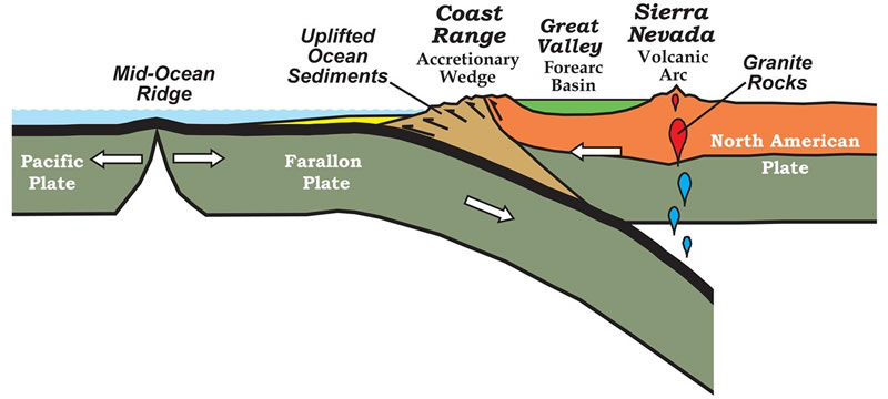
Another view of the valleys from Mather Overlook, which is the highest we could drive up the Wheeler Peak Scenic Drive at just over 9,000 feet in elevation. The Great Basin was formed as part of the Basin and Range Province of the United States. At one point in time the western edge of North America was being compressed by the Farallon Plate pushing up against North America, squeezing the continent as the Farallon plate subducted (went beneath) North America.

Graphic of the Farallon Plate subducting beneath North America. Image courtesy of the NPS.
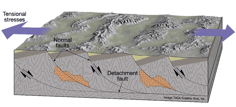
Eventually most of the Farallon Plate was entirely subducted beneath North America, especially along the Californian coast, and the compression was released. This essentially allowed North America to expand outwards, like a squeezed sponge being let go. This expansion thinned the crust, while also producing a series of linear mountain ranges and valleys.

Graphic of the Basin And Range expansion producing linear mountains and valleys. Image courtesy of ISU.edu.
As the expansion progressed, the crust was broken up into a series of smaller blocks. These blocks rotated as the crust stretched out. The rotation of the blocks produced the mountains along the upper corners, with gaps along the lower corners. These gaps eventually were filled with sediment eroded off the mountains, forming the valleys between the mountain ranged.

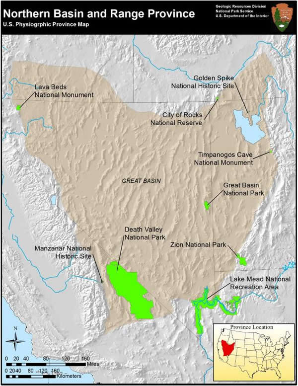
Coverage of the Great Basin. Image courtesy of the NPS.
With the thinning of the crust, this area also ended up being lower than the surrounding regions. Because of this water is not able to flow out of the Great Basin, hence the terminology of "basin". Unlike water along the eastern portion of the country and along the west coast, water here does not reach the oceans. All precipitation here eventually ends up in end-basins, such as the Great Salt Lake, where its only outflow is through evaporation.
.jpeg)
The rocks within the South Snake Range are mostly comprised of sedimentary rocks like sandstones, shales, and limestones that were all deposited during the Cambrian Period, around 550 million years ago. Seen here is the principle limestone of the region, the Pole Canyon Limestone, and the one in which the Lehman Caves was developed within. The Pole Canyon Limestone was deposited within a warm, shallow sea near the equator. This limestone formed from the dead shells of ancient sea creatures that built up over time. These shells, made up of calcium carbonate, naturally dissolve in acids, even if the water is only slightly acidic.
.jpg)
Over time the limestone was slightly metamorphosed (producing small amounts of marble). It was also cracked and fractured from the mountain building events (orogenies). You can also see that the limestone was rotated during these events, as seen in the lower part of the cave map. As the rocks cracked, this allowed ground water to seep into the limestone. The groundwater, which becomes carbonic acid by absorbing carbon dioxide from the soil and air, slowly dissolved away the limestone as it passed through the cracks. Over time, those cracks widened from the dissolution.
.jpg)
Here is the original, natural cave entrance to Lehman Caves. This is up above the current entrance, which was blasted into the caves through the limestone walls.
.jpeg)
As the water dissolves the limestone, it also deposits limestone. This is how cave formations are formed. The tiny bit of calcite that is within the dissolved water precipitate out of the water as the water drips off the surface of the rocks. Here stalactites are continuously formed and getting bigger as water runs down them from the overlying limestones. Calcite deposits on the tip of the stalactite, and whatever calcite remains within the water can then get precipitated directly below the stalactite on the ground as a stalagmite. These eventually will meet to form a column, as seen here in the background.
.jpeg)
Lehman caves is covered in absolutely gorgeous formations throughout the caves.
.jpeg)
Some of the thinner, soda straw, stalactite formations.
.jpeg)
Looking up at some of the stalactites directly above the narrow passage.
.jpeg)
View of some of the fantastic cave formations.
.jpeg)
More soda straw formations. You can see here the tube through which the water is traveling, giving the soda straws their name, from the overlying limestone. As the water reaches the end of the straw, calcite is deposited at the tip, creating new straw layers as the stalactite grows. Eventually these straws will close up and build outwards, producing the more typical stalactite formations.
.jpeg)
There is even standing water within the caves here, that very slowly seeps down into the limestone and other rock formations below the cave floor.
.jpeg)
Some more columns, stalactites, and stalagmites.
.jpeg)
More cave formations. Here showing a few of the "draperies", which are cave formations formed as water flows down the the side of the cave. These are more often known as flowstones.
.jpeg)
Some of the more delicate features within the cave. All cave formations form a type of rock known as travertine. Travertine is a product of the flowing water precipitating calcite, and can be formed within caves as seen here, or outside caves where flowing water is precipitating calcite, such as around geothermal features.
References
https://www.nps.gov/subjects/geology/plate-tectonics-subduction-zones.htm
http://geology.isu.edu/Alamo/rocks/basin_range_uplifts.php
https://www.nps.gov/articles/basinrange.htm
https://www.nps.gov/grba/learn/nature/the-formation-of-lehman-caves.htm


