
-Stage 3.4-
Stratigraphy
Stratigraphy is the study of the rock layers and the order of events that happened to them. Not only does this include deposition of the layers and the order that they were deposited but also anything else that happened to the rocks such as faulting, folding, tilting, and eroding. This is often one of the more enjoyable things to do in basic geology, since it is like a big puzzle that needs to be put together.
Click Here for a downloadable Powerpoint version of the Stratigraphy exercise below
Unconformity - An unconformity is a buried erosional surface. What this means is that it is an old surface that was exposed to the elements for an extended period of time and then buried. It usually means the structures below it are truncated in some variety. There are 3 types of unconformities.
Angular Disconformity - This is an unconformity between strata, where the strata (rock units) is not parallel above and below the unconformity. Usually this occurs when one set is folded or tilted and the above layers are not.
Disconformity - This is an unconformity between parallel layers. It indicates a gap in time and is often hard to identify. Some identifying features are an irregular surface (wavy instead of flat) and inclusions (portions of the underlying rock within the above rock).
Nonconformity - This is an unconformity between igneous/metamorphic rocks and sedimentary rocks.
Erosion - The current surface that is actively being eroded. This is always the last thing to be added on a stratigraphy section.
Tilting - Rock strata always form horizontally, so anything not horizontal has been acted upon. If they are straight but at an angle they have been tilted.
Folding - If the rocks are bent, they have been folded.
Faulting - If there is a break and movement within the rocks, this is a fault.
1. Oldest rock layers are on the bottom. Younger rocks almost always overlie older rocks.
2. Start listing things from oldest to youngest
3. Always do in pencil - You will make mistakes
4. Rocks originally formed in horizontal layers - So if anything is not horizontal and flat something happened to them. This needs to be noted.
5. Anything that crosses another formation must be younger - i.e. A rock unit must exist before you can fold it or fault it.
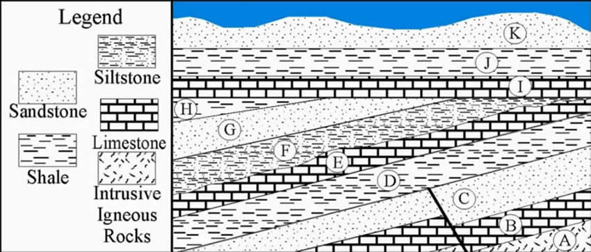
The above diagram is an example of a Basic Geology stratigraphy exercise. The legends lists what the types of rocks are that are illustrated. We will go through how to do this step by step.
Step 1
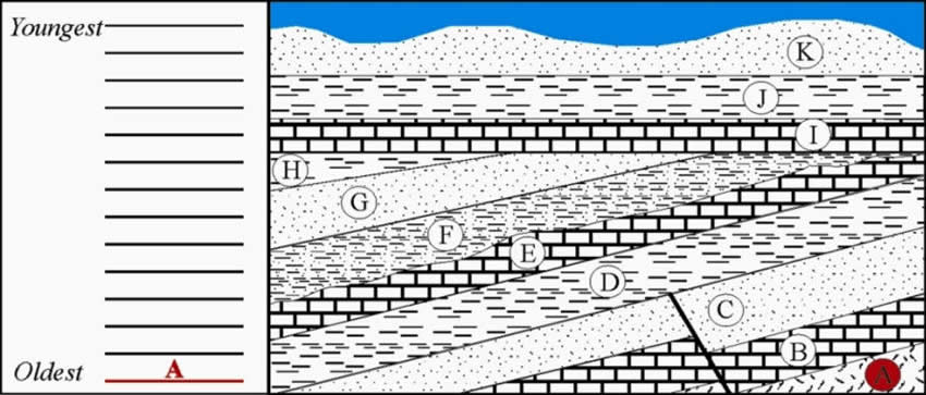
The first step is identifying the oldest rock unit, which in this case is the deposition of the intrusive igneous rock on the bottom.
Step 2
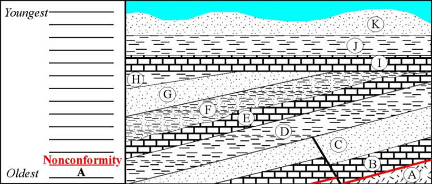
The second step is the Nonconformity since the rocks overlying the igneous rocks are sedimentary rocks (see definitions).
Step 3
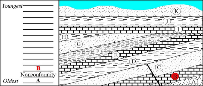
The third step is the deposition of Limestone. This indicates a deep water environment.
Step 4
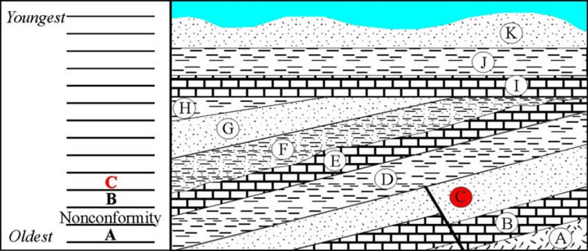
The fourth step is the deposition of Sandstone. This indicates a shallower environment, possibly a beach.
Step 5
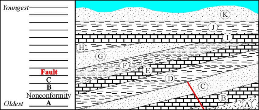
Now we have a fault. Since the fault only cuts across A, B and C is has to be younger then those 3 and older than D.
Step 6
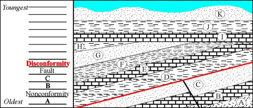
Next comes a disconformity. Even though there is no irregular surface and no inclusions this is still a disconformity. You can tell because the fault was cut off and leveled flat. It is not a nonconformity since they are both sedimentary layers. It might also be considered an angular unconformity since the layer below was altered but disconformity is fine.
Step 7
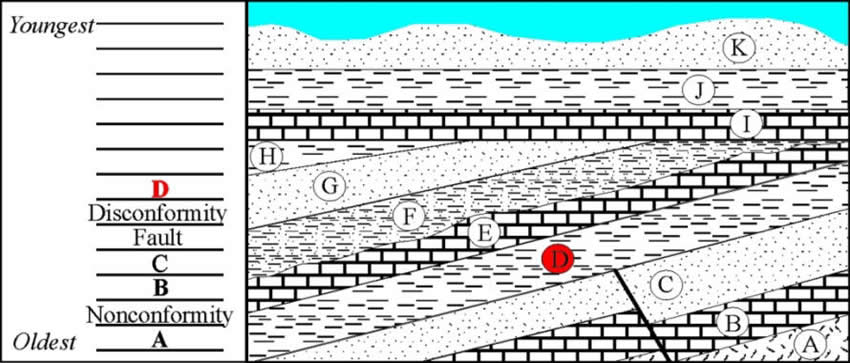
The next layer is D. The shale was deposited in calm water further off shore than the sands.
Step 8
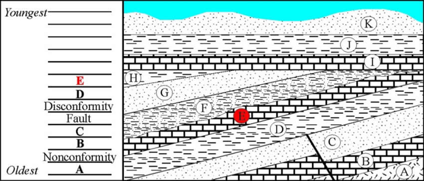
The next layer is E. The limestone was deposited in deeper water than the shale.
Step 9
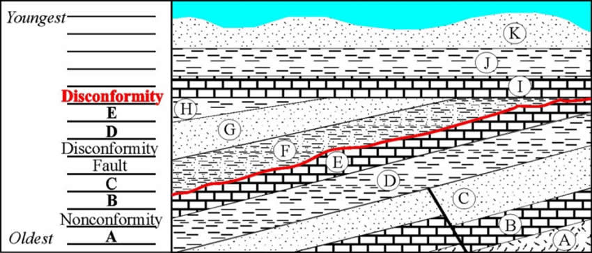
After E is a disconformity. This means that unknown layers have been erased by erosion. It essentially represents a gap in history.
Step 10
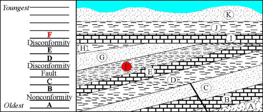
The next layer is F. The siltstone was deposited in calm deep water with a slight influx of sediment. The depth is between that of sandstone and shale.
Step 11
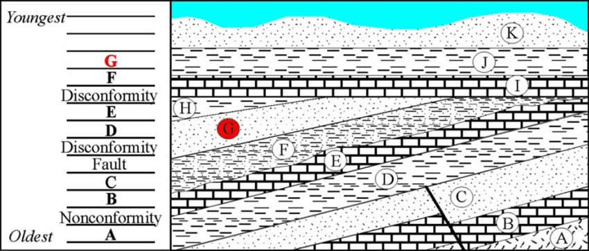
The next layer G, a sandstone, was deposited in shallower water then F, possibly again representing a beach.
Step 12
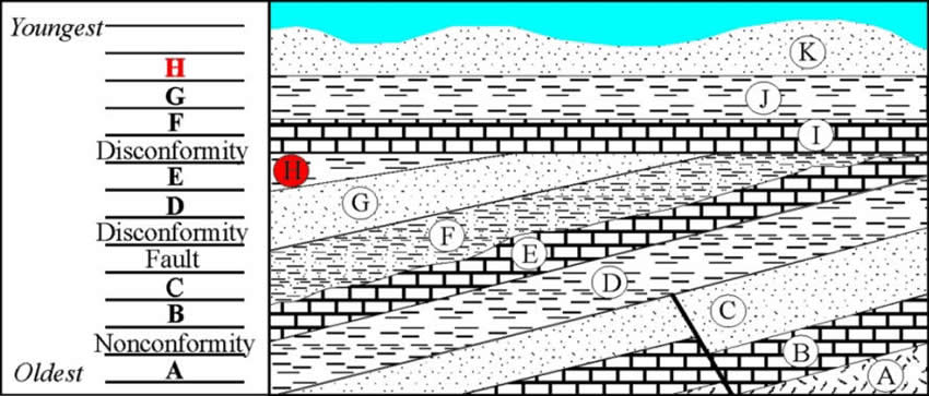
H, a shale, represents a deepening again of the water. Now you can see that commonly when rocks are deposited, the water level fluctuates causing different types of rocks to be deposited. This can be caused by a variety of different means such as sea level changes, the ground moves up and down, and/or deposition of sediment cause the ground to be built up causing a shallower water depth.
Step 13
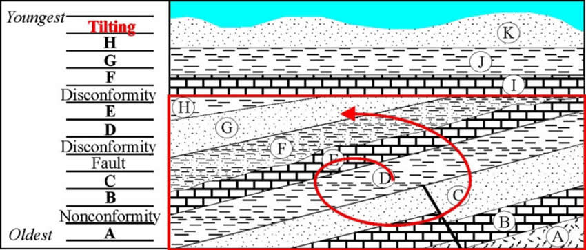
Next comes tilting. Everything through H has been tilted so tilting has to be younger than A-H and older than I since I is not tilted.
Step 14
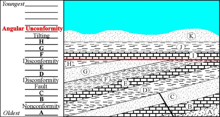
Always after tilting or folding comes an angular unconformity because the strata above always gets deposited horizontally while the below layers are altered.
Step 15
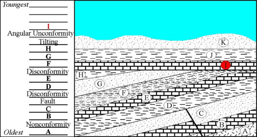
After the tilting and erosion the last stage of deposition starts with layer I, the deepest layer of deposition.
Step 16
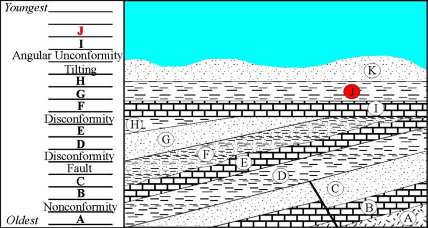
The water shallows a little more and J is deposited.
Step 17
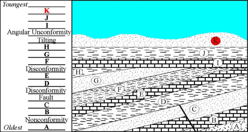
The final layer left is K, which was possibly deposited on a shoreline.
Step 18
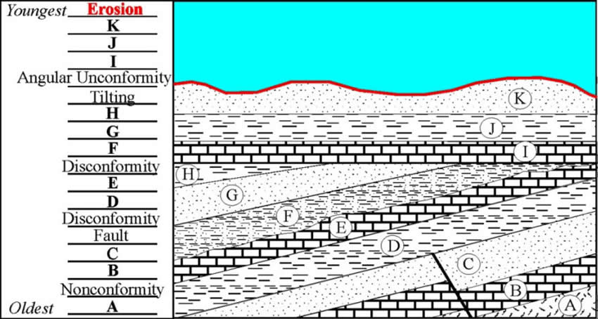
The final stage is erosion which is currently acting on the surface.