
-Stage 5.2-
Geology Through Literature
Where classic literature is used to help explain geological concepts.

I am trying to read the 100 Hundred Books ever written (you can check that out HERE) and I have come across several instances where there is geology placed into the books. Sometimes it is a description of a place, sometimes it is to give a background of a town, but it always something that gets me thinking, "Hey, I wonder if that is true". So I check it out, do some research, and before long I have an assignment ready to be given out to a class. Here is the compilation of that work, piece by piece. As I come across a topic I will add to this page.
Available Geology Reviews:
Hans Christian Anderson's Complete Fairy Tales
The World as Will and Presentation
A Connecticut Yankee in King Arthur's Court
Hans Christian Anderson's Complete Fairy Tales
Despite this not being my favorite book I ever read, or even anywhere near an enjoyable book, there were actually quite a bit of geological references sprinkled through Anderson's publishing history. Anderson was also fairly accurate in a lot of his geologically descriptive passage that are still accurate to this day, even almost 200 years later. Since there are so many geological references throughout his Fairy Tale career, I have noted each story from which the reference comes from.
The Galoshes of Fortune (1838)
Part III. The Watchman's Adventure
The Speed of Light
"But all this is like the gait of a sloth, or the pace of a snail, in comparison with the speed of light, which travels nineteen million times faster than the fastest race horse.... The sunlight takes eight minutes and some odd seconds to travel nearly one hundred million miles."
The speed of light has currently been measured to be 3 x 10^8 meters per second (or more accurately 299,792,458 m/s).
The maximum speed of a race horse is ~44 miles per hour, or ~0.122 miles per second.
Converting, the speed of light is therefore ~670,000,000 miles per hour, or ~186,000 miles per second.
The speed of light then works out to ~15 million times the speed of the fastest race horse. Of course you must take into account that perhaps the fastest race horse of today is not the same as the ones in the mid-1800's. So if you had a race horse with a top speed of 35 miles per hour, then indeed, the speed of light would be 19 million times faster.
My big question here though, was when was the speed of light determined? This story was published several decades before Einstein, so who discovered how fast light moves and how?
The speed of light was actually determined almost 350 years ago. In 1676, the Danish astronomer Ole Roemer was studying Jupiter's moon Io. By studying the length of the eclipse during different times of the year, Romer hoped to determine an accurate orbital period of the moon. The orbital period, determined to be 1.769 Earth days, was watched by Romer over many years and he noticed that the time intervals between eclipses wasn't consisted. As the Earth moved towards Jupiter, the eclipses came earlier. As the Earth moved away from Jupiter, the eclipses came later. He estimated that there was a difference of 22 minutes between the two extremes. The cause of this delay, he determined, was the time that the light needed to cross space from the closer orbital point to the further orbital point. Dividing this time by the diameter of Earth's orbit, should give a fairly accurate value for the speed of light.
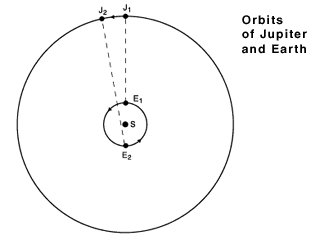
Illustration of how Romer determined the speed of light from the time of Io's eclipse. Image courtesy of AMNH by Diana Kline.
This calculation was done by Dutch scientist Chistiaan Huygens, finding the value to be 131,000 miles per second (off by about 30%). The difference from the true value was due to inaccuracies in the time calculation by Romer (actually 16.7 minutes, not 22) and imprecise knowledge of the Earth's orbital diameter. Even with the incorrect speed determined, he was at least within the correct ballpark and his method for determining the speed of light was accurate.
The Moon
In a few seconds the watchman took in his stride the 260,000 miles to the Moon. As we know, this satellite is made of much lighter material than the earth, and is as soft as freshly fallen snow. The watchman landed in one of the numerous mountain rings that we all know from Doctor Maedler's large map of the Moon.
The novel Vanity Fair, happened to also bring up the topic of the distance to the moon and was published about 10 years after this book. I had broken down the early history of how the distance to the moon was calculated there.
For here I want to focus on three things. The first is the assumption here that the moon was made of a much lighter material than the Earth. We now know that the moon not made of softer and lighter stuff than the Earth, it is actually made of the same rocks as the Earth, and that is because it was formed from the Earth. Early in the history of the Solar System, there was a proto-Earth and another planet known as Theia. Theia crashed into Earth in its early history, melting both planets and combining them into one with a much smaller mass spinning off to form the moon. Because of this, chemically speaking, the moon is identical to the Earth. However, over time as the Earth has aged, it's rocks have differentiated from each other to produce varying rock types in different environments and depths, whereas the moon, being far smaller, cooled far quicker and is a much more homogenous mass.
The second question brought up is, is the surface of the moon really as soft as snow? The surface of the moon has been under constant bombardment of meteoroids that have been pummeling the lunar surface for nearly the entire 4+ billion history of the moon, leaving behind a layer of rock dust. It was even thought that the first people to land on the Moon in Apollo 11 could potentially sink right into the lunar soil because of this dust. That however, did not happen, since even though there is a fine layer of dust over the entire moon, the rocks, dust, and other debris have compacted over time just below the surface, providing a firm surface to stand, and land, on.
Copy of Mädler's original 1834 moon map. Image courtesy of Worthpoint.
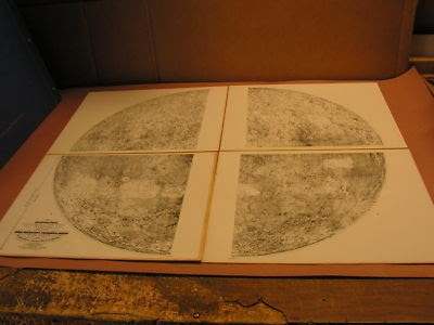
And the third thing is the map of Doctor Maedler. It turns out that shortly before this short story was written, that the first lunar map was published in 1834 by Johann Heinrich von Mädler. Originally broken up into four smaller section, it was eventually combined together into one very large map by 1837. This map gave us our first detailed, and widely available, map of the moon.
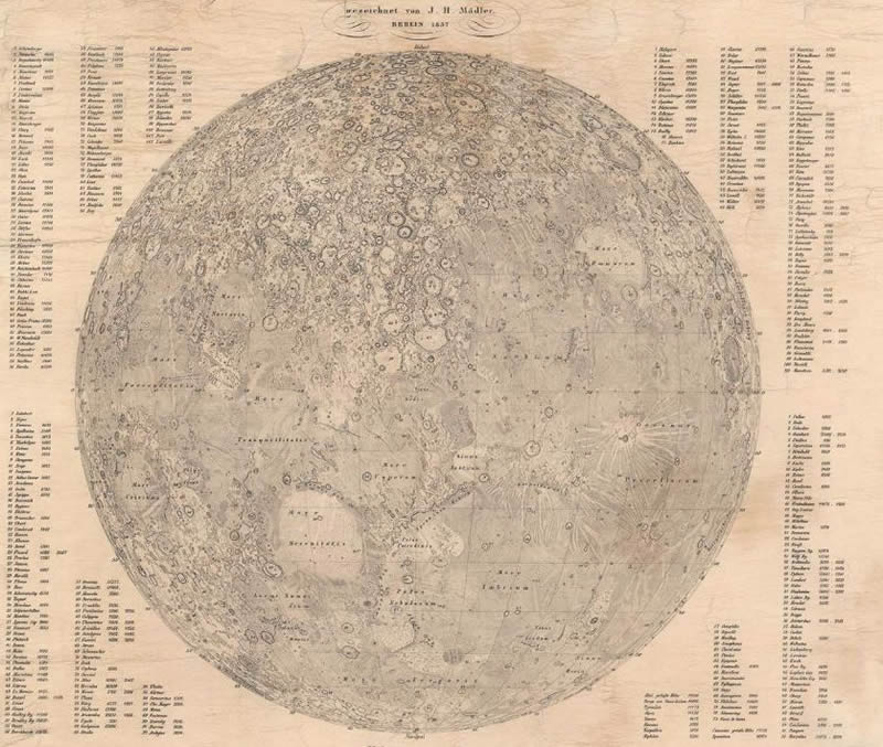
Mädler's 1837 version of the Moon map. High resolution version available at Geographicus.
So it turns out there actually was a highly detailed map of the moon as described by Anderson that could be used as a scientific basis for fictional landing sites.
What the Moon Saw (1839-1840)
Twelfth Evening
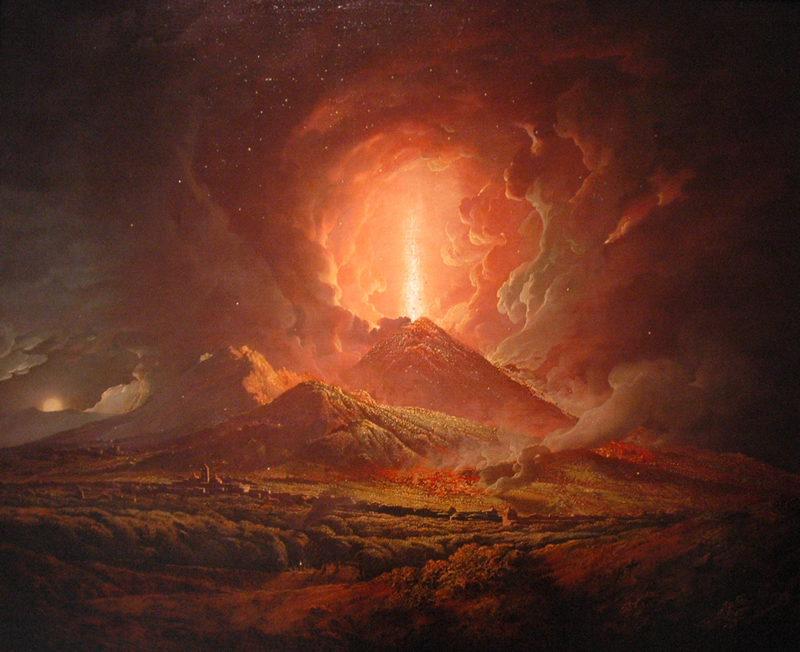
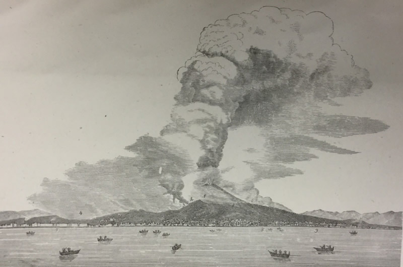
Mount Vesuvius
"I shall give you a picture of Pompeii," said the Moon. "I was outside the city, in the Street of the Tombs, as they call the place where happy youths, with wreaths of roses on their heads, once danced with the fair sisters of Lais. Now the silence of death reigns there.
"German soldiers in the service of Naples kept guard, and played cards and diced. A group of strangers from beyond the mountains walked into the city, conducted by a guard. They had come to see, in the full clear rays of my light, the city arisen from the grave. I showed them the ruts of the chariot wheels in the streets paved with great slabs of lava. I showed them the names upon the doors and the signs still hanging before the houses. In the narrow courts, they saw the fountain basins ornamented with shells, but the waters no longer spouted forth. No longer were songs heard from the richly painted chambers, where the bronze dogs kept watch before the doors. It was the City of the Dead. Vesuvius alone still thundered his eternal hymn, and each stanza of it men call a new eruption. We visited the Temple of Venus, built of pure white marble, with its high altar in front of its broad steps; the weeping willow has sprung up between the columns. The air here was transparent and blue, and in the background loomed Vesuvius, black as coal, its flames rising straight as the trunk of a pine tree. The glowing smoke cloud lay in the still calm of the night like the crown of the pine tree, but red as blood."
As is relatively well known, the city of Pompeii, located 14 miles to the southeast of Naples, was buried in ash after the eruption of the volcano Mount Vesuvius in 79 AD. This eruptive cloud of heated gasses, ash, and other pyroclastic debris asphyxiated the populace and buried it in ash, preserving the town, and the people, to this day. As noted in the text, even the ruts in the streets were preserved.
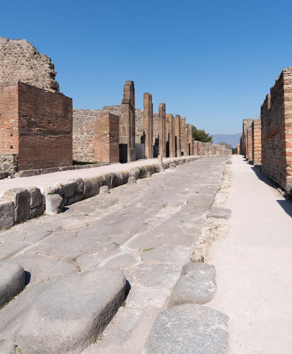
The street Via dell'Abbondanza in Pompeii with the street car ruts visible. Image courtesy of Britannica.
The city itself was also built on top of lava flows, being located very close to the volcano. Vesuvius, although not historically active prior to 79 AD, is a very active volcano. The people of Pompeii and surrounding towns likes Herculaneum were unaware of the danger that they were in but just being in the vicinity of the mountain. That time has passed and now people are fully aware of the hazards in the area, many of those from the repeated eruptions of Vesuvius since 79 AD.
The ruins of Pompeii were discovered in the late 16th century with excavation work on the city beginning in 1748 under the patronage of the king of Naples, Don Carlos, carried out by the military engineer Karl Weber. During this time, the excavations were haphazard and often by untrained treasure seekers.
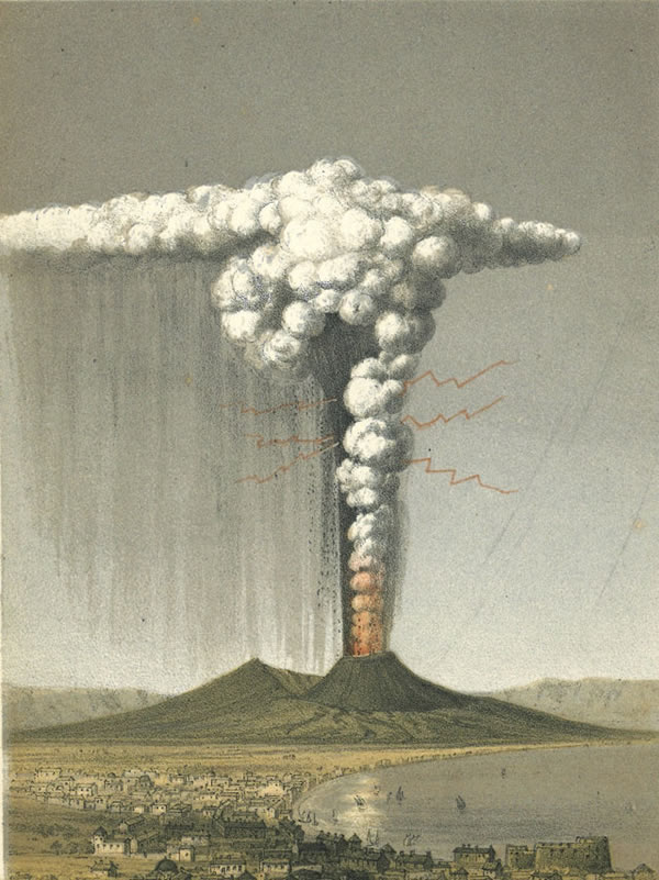
As noted in the excerpt, these excavations took place in the shadows of eruptions by Vesuvius, with eye witness accounts describing the very same pillar of fire erupting from the volcano itself during this time. Between the time the excavations started (1748) and the time the story was published (1840), there were 7 separate periods of volcanic activity, with several containing "pillars of flame". The most recent one to the publication in January of 1839 had this event described:
Outflow on 31 Dec 1838. At dawn of 1 Jan 1839, dark eruption column, lava flow to W . Between 1 and 4 Jan, fracture of the cone to E and W, on 2 Jan high white cloud; then lava to E (Boscotrecase) and W (Canteroni); lava fountains up to 400 m, and black ash on Boscotrecase and Castellammare. After the eruption the crater was funnel-shaped with a diameter of 700 m and a depth of 285 m (Pilla, Baratta) (Courtesy of MTU.edu)
And not only are there written descriptions, but visual recreations in the forms of paintings from the time. Below are pictures of eruptive columns from the 1788 eruption and the 1822 eruption.
Vesuvius from Posillipo by Joseph Wright of Derby, painted ~1788. Image courtesy of Wikipedia.
Vesuvius in eruption, October 1822. George Poulett Scrope, Considerations on Volcanoes, 2nd ed. (1864), frontispiece. Image courtesy of the BBC.
So, it would appear that Anderson was very well informed with the geological activity going on during his time.
Ole, The Tower Keeper (1859)
First Visit
Listening to the Rocks
Among the books I had recently lent Ole was one about pebbles, which had greatly pleased him.
"They are truly veterans from olden times, those pebbles," he said, "yet people pass them by without thinking, and trample them down in fields or on beaches, those fragments of antiquity. I have done so myself. From now on I shall hold every paving stone in high respect!...
"The romance of the Earth is truly the most fascinating of all romances. It's a shame we can't read the first parts of it; but they're written in a language we haven't learned yet; we have to dig away among strata and rocks, puzzling out bits here and there from the early acts of earth's drama.... The crust on which we move remains solid so that we never fall through, and so it is a story of millions of years, with steady progress.
"Many thanks for your book on pebbles; those old fellows could tell us so much if only they could talk.... And it makes you feel so ridiculously young, compared with the millions of years of these venerable stone!"
"...I was rolling through millions of years with my rocks, watching them break loose up in the North, drift along on icebergs ages before on a reef, and at last peer up through the water and say, 'This shall be Zealand!'..."
What Andersen is describing is exactly what geologists hope to decipher. Geologists read the rocks. They listen to what the rocks have to say and have been doing it far before Andersen's time period. Which he should be aware of with his comments about the earth being millions of years old, since geologists are the reason that we even thought that the earth was millions of years old at that time (we now know it to be ~4.543 billion years old).
Layers of the Earth
The scientist that is often touted as the father to modern geology is James Hutton, who lived from 1726 to 1797. He is the one who came up with some of the first principles of geology, which are his way of essentially listening to what the rocks had to tell us. James Hutton's primary theory that he developed was the Principle of Uniformitarianism, which stated that the present is key to the past and that all processes happening on Earth today are the same ones that happened on the Earth in the past. This means that when we have ripples and mud cracks in modern day sediments, they can help us identify ripple marks and mud cracks in the rock record. Since everything happening today has happened in the past and erosion and deposition are incredibly slow processes then the age of the Earth must be very, very old. Although he couldn't be sure of an exact age of the Earth, one could easily assume the Earth was millions or even billions of years old based on the rates of modern day erosion and sedimentation.
His research continues today with geologists "reading the rocks" and listening to their life stories. Then taking this information and combining it with the histories of other rocks, until we have a full and complete global history dating back to the beginning of the earth. We aren't fully there yet, and we may never get fully there, but it is an ever hopeful promise that we may.
Shooting Stars
"Then three or four beautiful shooting stars fell; they shone brightly, and started my thoughts off in an entirely different direction. Does anybody know what a shooting star really is? The learned do not know!..."
Although Andersen claims that the "learned do not know", we do know today what they are. They are bits of cosmic debris that burns up when it enters our atmosphere, technically called a meteor. The meteor is the flash of light that we see when the debris enters the atmosphere and the debris itself is called a meteoroid.
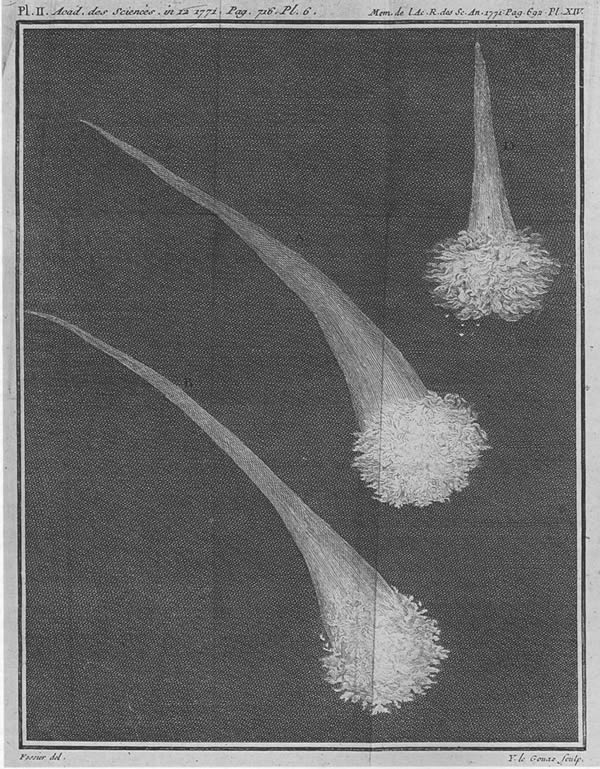
Illustration of a "fireball" from a 1771 publication by Le Roy (Marvin, 2007).
What interests me about this statement is when did scientists begin to learn about meteors and shooting stars. One of the first scientists to suggest that the fireballs were real events was Ernst Chladni in 1794. He hypothesized that shooting stars, fireballs that came crashing to earth, and the physical meteorites were all related phenomena. Although there was resistance to the idea at the time, he persevered until his death in 1827. It was not until 1834, that scientists had been able to start piecing together that meteor showers were tied to specific orbital events, and from here to realize that shooting stars were actually pieces of orbiting materials burning up in the atmosphere.
It took until 1862 when the hypothesis that shooting stars had an extraterrestrial origin had firmer proof with the prediction and the tying of comets to specific orbits and times of the year. With these observations, future meteor showers were able to be predicted including the 1866 Leonid shower. So, even though the story was written in 1859, there still was significant evidence at that point that meteoroids were the cause of the shooting stars with firmer proof only a few years away.
Beautiful (1859)
Eruptions
It was a delight to hear Mr. Alfred speak. He told them of Naples, of trips to Mount Vesuvius, and showed them colored prints of some of the eruptions. The widow had never heard of such things before, much less taken time to think about them.
"Mercy save us!" she said. "So that's a burning mountain! But isn't it dangerous for the people who live there?"
"Entire cities have been destroyed," he answered. "For example, Pompeii and Herculaneum."
"Oh, the poor people! And you saw all that yourself?"
"Well, no, I didn't see any of the eruptions shown in these pictures, but I'll show you a drawing I made of an eruption I did see."
He laid a pencil sketch on the table, and when Mamma, who had been studying the highly colored prints, glanced at the black-and-white drawing, she cried in amazement, "When you saw it did it throw up white fire?"
For a moment, Alfred's respect for Kala's mamma nearly vanished; but then, dazzled by the light from Kala, he decided it was natural for the old lady to have no eye for color. After all, it didn't matter, for Kala's mamma had the most wonderful thing of all—she had Kala herself.
We head back to Mount Vesuvius, as we talked about previously with the What the Moon Saw story. The only thing to add here of note was that Herculaneum was also well known by this time, with the excavation actually having started before the excavation of Pompeii in 1748. Herculaneum itself was discovered after Pompeii, in 1709, and systematic excavation beginning in 1738, a full decade before Pompeii. The note in the text about Mr. Alfred showing Mamma the "colored prints", I must assume that he means copies of colored paintings and drawings, since colored photography had yet to be invented.
Vesuvius in eruption, April 26, 1872. Original caption 'from a photograph taken in the neighbourhood of Naples''. (Palmieri and Mallet, 1873). Image courtesy of Oxford Sparks.
However, an interesting note is that the first photograph of a volcanic eruption is believed to be the 1972 eruption of the very same Mount Vesuvius, which aided the Director of the Vesuvius Observatory, Luigi Palmieri, to document the eruption with a dramatic line drawing.
A Story from the Sand Dunes (1859)
Shoreline Erosion
Still, it is easy to imagine yourself back in times more remote than even the reign of Christian VII, for now, as then, the brown heath of Jutland stretches for miles with its barrow, its mirages, its winding, rough, sandy roads. To the west, where broad streams flow into the fjords, there are marshes and meadows, encircled by the high sand hills which rise up toward the sea like an Alpine chain with jagged summits, broken only by high banks of clay. From these the waves eat off giant mouthfuls year after year, so that the edges and summits topple down as though shaken by an earthquake. That's how it looks today, and that's how it looked many years ago...
The passage describes the persistent erosion along the western shore of Jutland, a region of Denmark, with Western Jutland bordering the North Sea.
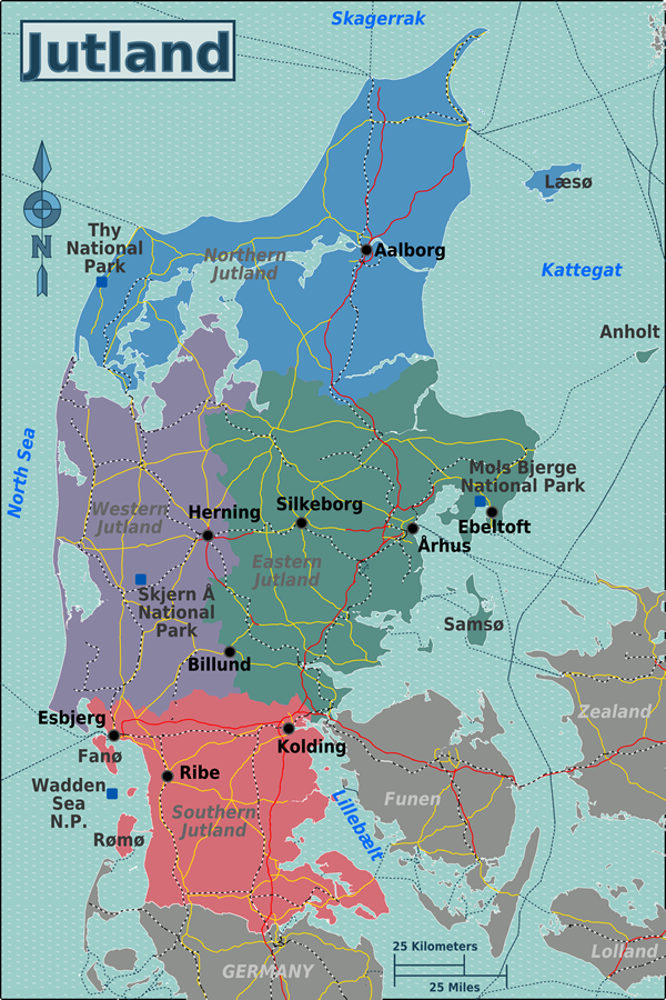
Map of Jutland, Denmark. Image courtesy of Wikitravel.
The beaches and the sand dunes of the Jutland coast were deposited during the last Ice Age consisting of clay and fine sand that total 100 meters of sediment deposited over 100,000 years. These deposits are known as the Skærumhede series.
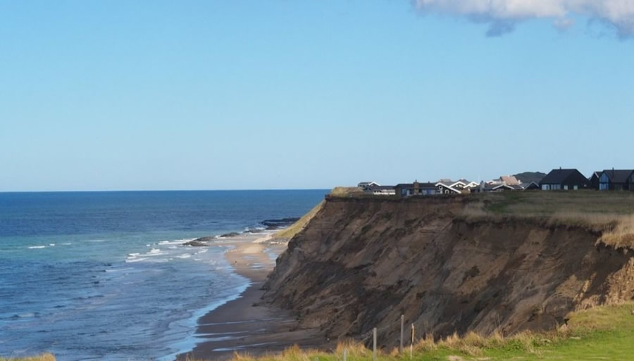
The Jutland western shore. Image by Lucia Margheritini and courtesy of Science Nordic.
These sediments make up much of the western coast, but they are slowly being transported out to sea due to coastal erosion. As the cliff faces are worn away at the bottom, the upper layers eventually collapse and then are carried away by the waves. Much of the erosion occurs during the winter months when the water levels are higher and storm levels are stronger, producing winds and waves capable of wearing away at the cliff face that is otherwise out of reach during calm, summer days.
The sediment along the coast is then transported through the longshore current from south to north. However, the amount of sediment removed is more than the sediment supplied by the current, so the coastline is in a losing scenario. It is estimate that it has been in a losing scenario since the last ice age, ~10,000 years ago.
And although this erosion has been continuing since long before and after Andersen's time, the current rate of erosion has been increasing. There are several reasons for this but mainly they can boil down to manmade impacts and climate change. Structures on the beach, scientists know, have a tendency to alter the erosion patterns, often producing more erosion in areas beyond where the structure are built. Think dams and sea walls. These structures stop erosion where they are built, but the lack of sediment within the water beyond these points allows for more erosion than would otherwise occur. With climate change there are many reasons for potentially accelerated erosion including: more and/or stronger storms, rising sea levels, and changes in weather patterns. It is estimated in this region that the changes in weather patterns, specifically more rain, has been the cause of the accelerated erosion, with the increased rain breaking down the cliff edges more readily than they were before.
The Ice Maiden (1861)
Glaciers
They had made the greater part of the journey, had climbed the highest ridges to the snowfields and could already see her native valley with the familiar scattered cottages; they now had only to cross the upper part of one great glacier. The newly fallen snow concealed a crevasse, not deep enough to reach the abyss below where the water rushed along, but deeper than a man's height...
The glacier lies like a rushing stream, frozen and pressed into blocks of green crystal, one huge mass of ice balanced on another; the swelling stream of ice and snow tears along in the depths beneath, while within in it dwells the Ice Maiden, queen of the glaciers.
Glaciers are essentially as Andersen describes them, big piles of ice that slowly move across the landscape. Mountain glaciers in particular are known for flowing down valleys, like rivers. In the upper part of the mountains, where it is colder, snow builds up over time. As more and more snow is dropped on the top of the mountain, eventually it starts to get compacted in the vertically lower layers, forming ice. As more and more ice builds up, the glacier starts to flow, like molasses, down the valleys. As the glacier moves down the valleys, the ice picks up and freezes small and large pieces of rocks and drags them along on the bottom of the ice. These rock fragments then grind down into the bedrock over which the glacier flows. Eventually the glacier reaches an elevation where it is too warm for the ice to remain frozen all of the time (like in the upper regions) and it starts to melt. Towards the end of the glacier where all of it has melted away, it acts like a conveyor belt, carrying all of the debris it eroded away and piling it up into one big pile of glacial debris called a moraine.
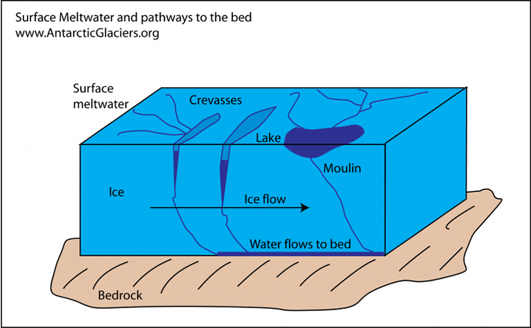
Glacial meltwater pathways. Image courtesy of Antarctic Glaciers.
Due to differences in temperature from the upper surface of the glacier and the bottom depths, the upper layers will sometimes melt from warming by the solar rays. This occurs even in the coldest of temperatures due to the ability of the sun's energy to melt the ice. This melted water then flows down into the glacier through large cracks in the ice known as crevasses. This meltwater will sometimes then flow all the way to the base of the glacier along the bedrock where streams can be formed.
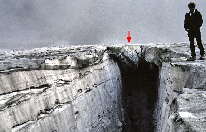
Snow covered crevasse. Image courtesy of SwissEduc.
Also as the glacier moves, the whole glacier may not always flow as one solid, cohesive unit. Going over uneven terrain, or variations in the width of the valley, will alter how the glacier flows. These flow changes then have the potential to crack the ice. These cracks are known as crevasses, and sometimes the crevasses can go from the surface all the way to the base of the glacier, which in some instances could be hundreds to thousands of feet thick. These crevasses are also often covered over with a thin layer of snow due to variations in movement of the ice. These thin crusts, or bridges, of snow make walking across the surface of a glacier a very dangerous thing to do if you don't know what you are doing.
Vänö and Glänö (1867)
Shoreline Geology
Near the coast of Zealand, off Holsteinborg castle, there once lay two wooded islands, Vänö and Glänö, on which were villages, churches, and farms. The islands were quite close to the coast and quite close to each other; now there is but one of these tracts remaining.
One night a fierce tempest broke loose. The ocean rose higher than ever before within man's memory. The storm increase; it was like doomsday weather, and it sounded as id the earth were splitting...
That night Vänö vanished into the ocean depth; it was if that island had never existed. But afterward on many a summer night, when the still, clear water was at a low tide, and the fisherman was out on his boat to catch eel by the light of a torch, he could, on looking sharply, see Vänö, with its white church tower and high church wall, deep down below.
...
You went away from there ... and after a few years you have returned.... Where is Glänö? You don't see little wooded island before you; you see only open water. Has Vänö finally taken Glänö, as it so long was expected to? On what stormy night did this happen, and when did an earthquake move old Holsteinborg so far inland?
There was no stormy night; it all happened on cleat sunny days. Human skill built a dam to hold back the ocean; human skill dried up the water and bound Glänö to the mainland. The bay has become a meadow with luxuriant grass; Glänö has become part of Zealand.
If you try and search for the word "Glänö", most of the results are just for references to this specific story. However, I was able to find a bit for information after doing a search for the Holsteinborg castle, which does exist.
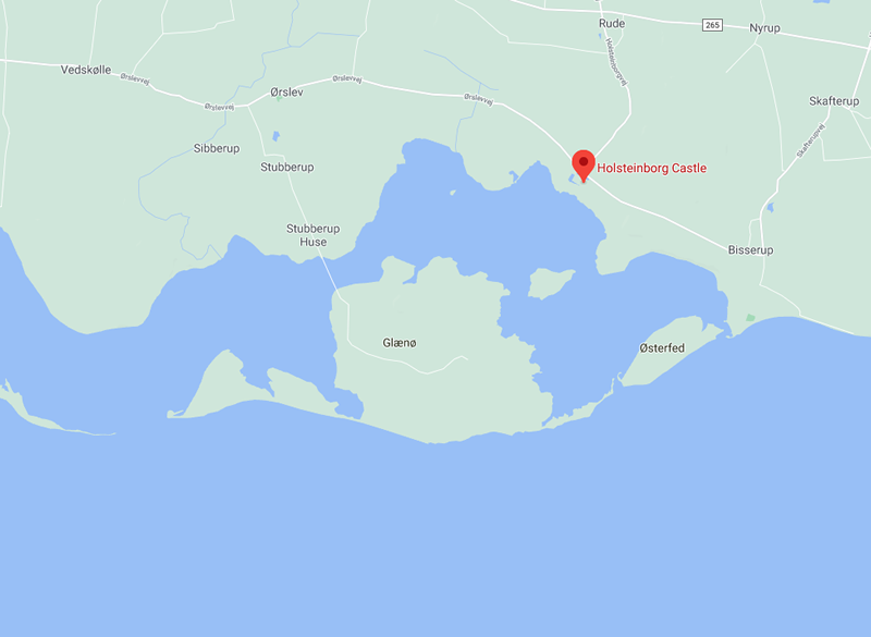
Google Maps of Holsteinborg Castle showing Glænø Island.
Based on the map of the castle, there sure enough appears to be an island, directly next to Holsteinborg Castle called Glænø. I feel this is far too close a coincidence to be happenstance. However, in the story, it specifically states that the island of Glänö was dammed up and incorporated into the mainland. Even though the map above doesn't appear that the island is not an island, let's look at the aerial photo to see if things get any clearer.
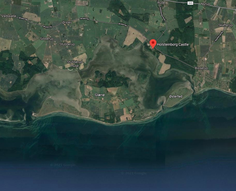
Aerial Photo of the area around Holsteinborg Castle. Image courtesy of Google Earth.
Here we can see a lot more sediment build up in the estuary behind the island, and that is because of the dam that is built to the island. In the picture here and above, the road that leads to the island on the northwest corner is on top of a 100 meter long dam. So, as the story stated, the residents built a dam, essentially merging the island with the mainland.
But where could Vänö (also spelled Vænø) be then?
There are a couple of theories that I have. My first theory is that the island directly next to Glænø, Østerfed could be a new name for the island. However, since this is clearly still an island, my guess is that this is not what we are looking for.
If this is not Vänö, then the island must once have resided within the bay to the south of Glænø called Smålandsfarvandet. If we look a bit further out from Glænø into the bay, there is an island with a similar sounding name.
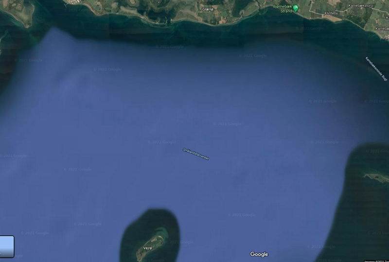
Smålandsfarvandet aerial image courtesy of Google Earth.
The island, Vejrø, does have a similar name, however based on the description, the island is not really "quite close", nor "near the coast". It is also not a sunken island. So, my last theory is that the island truly was sunk off the coast somewhere. But if it was, there is likely evidence in the bathymetry of the bay. There should be some sort of raised island under the water, as other parts of the text describe that the island is still visible on calm water days.
Although there are not a lot of publicly available bathymetry charts of Smålandsfarvandet, I did find a few that offered glimpses that there is a submerged land area about halfway between Glænø and Vejrø. As can be seen in the following bathymetry chart.
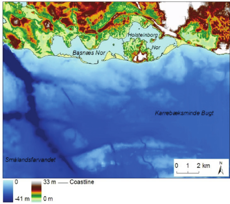
Bathymetry map off the southern shore of Glænø. Image courtesy of Kroon et al., 2015.
A little further investigation and it turns out this shallower area of the bay on the southern edge of the map above is actually a reef. It is known as the Kirkegrund Reef and parts of the reef reach as low as 1-2 meters below sea level (~5 feet).
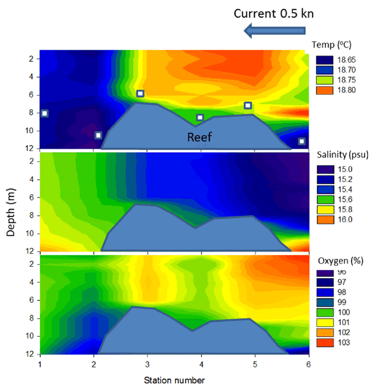
Cross section of the Kirkegrund Reef. Image courtesy of Stæhr et al., 2016.
The cross section above shows shallow areas around 6 meters below sea level, however other maps show a significantly shallower region in other parts of the reef. The further back in time that we go, the lower sea level was, so perhaps this was the island that Andersen was referring to. If we think that this island was once Vänö, then it is possible that legends grew up about this island off the coast that eventually was swallowed up by a big storm. And the things that the fishermen were seeing off shore was actually the reef far below the surface and not the remnants of various buildings once build on the island.
The Rags (1868)
Bedrock Geology
"I am Norse!" said the Norwegian. "And when I've said I'm Norse I guess I've said enough. I'm firm of fiber, like the ancient granite rocks of old Norway. The land up there has a constitution, like the free United States. It makes my fibers tingle to think what I am and to sound out my thoughts in words of granite!"
Norway's bedrock is truly ancient by no exaggeration of the term. The oldest rocks in Norway are part of the Fennoscandinavian shield, which are the Scandinavian Precambrian bedrock, the oldest rocks of which can be found along the northern edges of the country in Finnmark, Troms, and Vesterålen. These oldest rocks date back almost 3 billion years old.
The oldest rock in Norway at 2.9 billion years old. Image courtesy of the Geological Survey of Norway.
As you can see in the map below, most of these truly ancient parts of the Scandinavian shield are in the Finland and Russian parts of the Fennoscandian Peninsula.
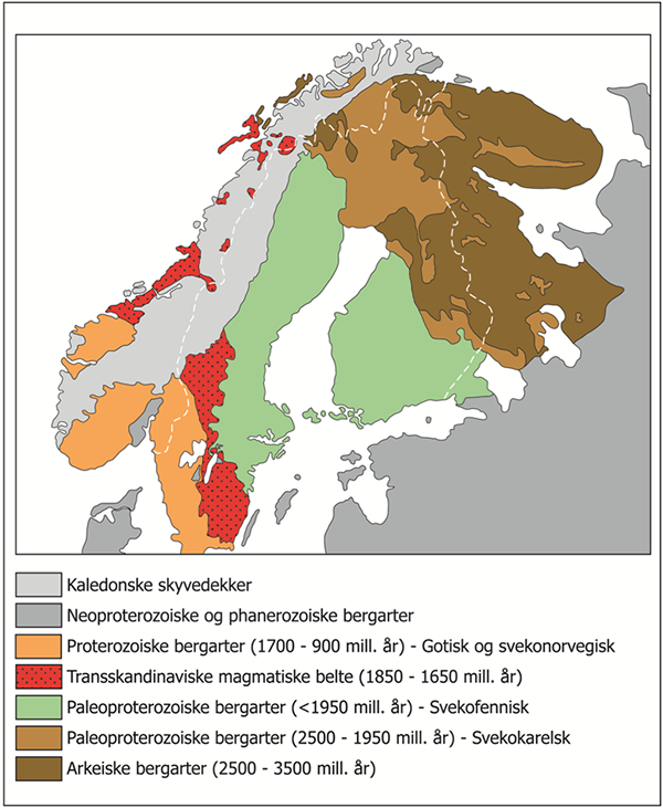
Bedrock geology of Scandinavia. Image courtesy of the Geological Survey of Norway.
The vast majority of Norway is underlain by incredibly old rocks, even those parts not in the northernmost regions. The question now is, are these rocks truly granites like the text says? Granite is often a term used as an all encompassing term for crystalline rocks. Just look at the countertop industry where everything is "granite" where much of the counter tops are not actually granite by the geological definition of the word.
Granite is an intrusive igneous rock that formed from the cooling of magma deep within the earth where the earth insulated the magma allowing to cool slowly. The slow cooling allowed the mineral crystals within the rock the time to grow creating the crystalline rock so well known as granite. The naming of an igneous rock is dependent on how the rock formed (intrusive versus extrusive) and what the mineral composition is, essentially how much quartz is there in the rock. To identify the rocks there is a chart/scale of intrusive igneous rocks which are identified based on the silica (quartz) content.
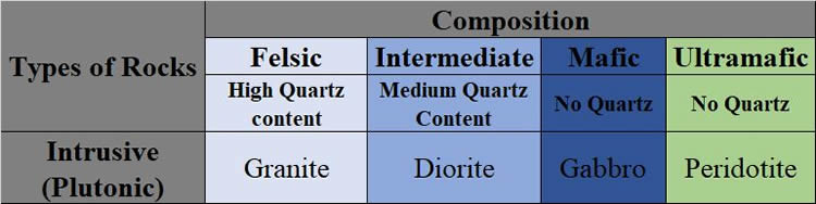
Basic Intrusive Igneous Rock Scale
On the high end of the scale with a high quartz/silica content is Granite, known as a felsic rock. In the middle, with an intermediate amount of quartz/silica, is Diorite. And on the low end of the scale with no quartz/silica is Gabbro and Peridotite. Igneous rocks with no silica are known as mafic rocks.
Really old rocks also have more instances where they can get metamorphosed. This means that they had been subject to increased heat and/or pressure. When that happens, the minerals within the rock change. The rocks don't fully melt, but the increased heat allows the elements within the rock to reorganize themselves forming new rocks. When granite is metamorphosed, it produces a metamorphic rock known as a gneiss (pronounced "nice"). Gneiss is the rock most often miscategorized as a granite, since they so often resemble one another, however there is a mineralogical and a structural difference between the two.
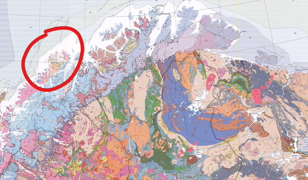
Portion of the Geological Map of the Fennoscandian Shield showing northern Norway. Circled rocks represent the oldest (Archaean rocks identified as "462") in Norway. Image courtesy of GigaPan.
Looking at a much more detailed geological map in the Fennoscandinavian shield, it turns out that oldest rocks within the Norwegian portion of the shield are indeed composed of granites and gneisses. The northernmost coastal rocks in Norway are identified on the geological map of the region as "462", these are Archaean granite, granodiorite, tonalite, and metamorphic equivalents. The other rocks of similar age are identified as "463", and these are migmatitic gneiss of granodioritic to dioritic composition.
Being so old, the rocks only represent the basement of the region and have several billion years of rock history deposited on top of them. They record the history of mountains built up, eroded down, built up again, and eroded down again. There is more history in these basement rocks than most rocks will ever see in their lifetime before they are broken down by the passage of time. So, like Andersen said, the northern portions of Norway really do contain "ancient granite rocks".
The Comet (1869)
Comets
Now there came a comet with its shiny nucleus and its menacing tail. People from the great castles and people from the poor huts gazed at it....
But a little boy and his mother still stayed inside their room. The mother believed ... that her son would soon die. The little boy lived many more years on earth. Indeed he lived to see the comet return sixty years later.
...
"This is the time to look at the comet," cried their neighbors....
The boy saw the bright ball of fire, with its shining tail. Some said it was three yards long, while others insisted it was several million yards long—such a difference.
In general a comet is is a body of ice, rock, and organic compounds that can be up to several miles in diameter. "Comets are thought to originate from a region beyond the orbits of the outermost planets. Scientists believe that gravitational perturbations periodically jar comets out of this population, setting these "dirty snowballs" on orbital courses that bring them closer to the Sun. Some, called long-period comets, are in elliptical orbits of the Sun that take them far out beyond the planets and back. Others, called short-period comets, travel in shorter orbits nearer the Sun" (Nasa.gov).
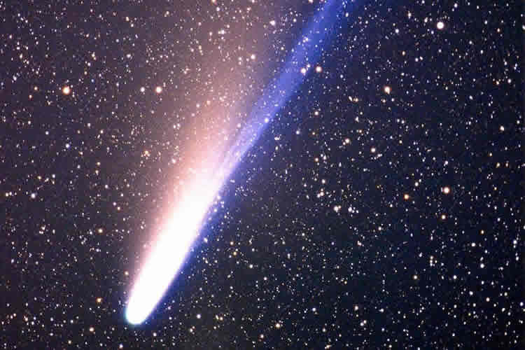
Comet 153P/Ikeya-Zhang which has the longest known tail at over a billion kilometers. Image courtesy of NewScientist.
Although many comets are known to have a return period, much of the comets with known return periods had only been discovered fairly recently. There are two types of comets based on their orbital periods; known as long-period comets, which are comets with orbital periods greater than 200 years, and short-period comets, with orbital periods less than 200 years. Even the short-period comets can be broken up into Halley-Type comets, which have orbital periods between 20 and 200 years, and Jupiter-family comets, that have orbital periods less than 20 years.
Besides Halley's comet, which was determined in 1705 by Edmund Halley to return at a set amount of time (75-76 years), there aren't many comets that have been identified with periodic return periods. To date, only ~300 periodic comets have been identified, with less than 10 identified by the publication of this story (1869).
The problem with identifying these comets is that typically only bright comets are easily identified in the sky, especially by the naked eye. These bright comets, often called "Great Comets", however usually need to be fairly large, pass closely to the sun, and pass closely to earth. Although these bright comets are bright enough to be seen by the human eye, their close approach to the sun often can spell disaster for the comet, reducing it to space dust. So many of the Great Comets are one time affairs. Halley's Comet being the exception of a bright comet that continues to have a periodic return.
Within the story Andersen seemed to take the appearance of a bright comet and a periodic comet and mixed them with his own tale of a man that would live another 60 years. To date there is only one comet with an approximate return periods of 60 years, and that was only discovered in 2015. This comet, C/2015 F5 (SWAN-XingMing), has a return period of 60.9 years and was only barely visible due to its mostly lack of a tail.
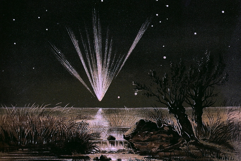
The Great Comet of 1861 as painted by E. Weiss. Image courtesy of Wikipedia.
The Great Comet of 1861 (C/1861 J1) would probably be the closest great comet to the time of publication. Although, as I said that many of the Great Comets are destroyed, it appears that this comet was linked with other pervious comets and had been determined to have an orbit of 407 years. As more time passes and more of the historical records are analyzed it will likely come that even more of the previously thought one-off comets will be determined to be linked, and/or have a periodicity themselves.
Andersen makes note of the length of the comet tail, in which I assume is a difference between looking at in in the sky (three yards long) and thinking of it in its real life length (several million yards long). In real life, the tail is created when solar winds and solar radiation pressure blows ionized gasses and debris off of the comet. This causes the tail to always be pointed away from the sun. Since the tail is a product of the sun, the closer to the sun that the comet gets, the longer and brighter that the tail gets. And there are actually two tails on a comet, the blue tail is formed from the ionized gasses blowing off the comet ball while the white/pink tail is from the small dust particles.
Typical visible comets can get a tail that can reach up to 150 million kilometers, much more than even the high-end length noted in the story. And as can be seen in the top picture here, the length of the tail can even get to over a billion kilometers in length.
References
https://www.amnh.org/learn-teach/curriculum-collections/cosmic-horizons-book/ole-roemer-speed-of-light
https://www.nhm.ac.uk/discover/how-did-the-moon-form.html
https://www.iop.org/explore-physics/moon/surface-features-moon#gref
https://www.worthpoint.com/worthopedia/mappa-selenographica-1834-lunar-map-142361918
https://www.britannica.com/place/Pompeii
http://www.geo.mtu.edu/volcanoes/boris/mirror/mirrored_html/VESUVIO_1631-1944.html
https://19.bbk.ac.uk/article/id/1713/
https://en.wikipedia.org/wiki/Vesuvius_in_Eruption_(Wright_painting)
https://onlinelibrary.wiley.com/doi/pdf/10.1111/j.1945-5100.2007.tb00606.x
http://articles.adsabs.harvard.edu//full/1966Metic...3...11R/0000011.000.html
https://www.oxfordsparks.ox.ac.uk/content/first-volcanic-eruption-be-photographed
https://wikitravel.org/en/Jutland
https://www.swisseduc.ch/glaciers/glossary/snow-bridge-en.html
https://www.google.com/maps/place/Holsteinborg+Castle
https://www.worldscientific.com/doi/abs/10.1142/9789814689977_0009 https://dce.au.dk/fileadmin/dce.au.dk/Udgivelser/Notater_2016/Monitoring_species_using_edna.pdf
https://www.ngu.no/en/topic/regional-geology
https://www.ngu.no/en/topic/bedrock-geology
http://www.gigapan.com/gigapans/171438
https://minorplanetcenter.net//iau/lists/PeriodicCodes.html
https://en.wikipedia.org/wiki/C/1861_J1#/media/File:Great_Comet_1861.jpg
http://articles.adsabs.harvard.edu/pdf/1995PASJ...47..699H
https://skyandtelescope.org/astronomy-resources/why-do-comets-have-tails/
https://starchild.gsfc.nasa.gov/docs/StarChild/solar_system_level2/comets.htm
https://en.wikipedia.org/wiki/C/2015_F5_(SWAN-XingMing)
 Despite the main character of The Tin Drum by Günter Grass working for a headstone carver, there isn't much geology in the book. There are frequent off-handed mentions of different rocks such as granite or marble, but nothing that could be placed in context. There is one instance in the book, though, that we could delve into.
Book 2, Chapter "He Lies in Saspe"
"The (Saspe) cemetery was square with a wall running around it. We went in on the south side, through a little gate that was covered with ornamental rust and only supposed to be locked. Most of the tombstones were of black Swedish granite or diorite, rough hewn on the back and sides and polished in front."
The Saspe Cemetery is on the outskirts of Danzig, Poland, which is now known as Gdańsk. Gdańsk is a port city located on the Baltic sea in northern Poland. This means it was directly across the water from Sweden and could easily have received Swedish stones.
Although many non-geological people will call anything that isn't marble "granite", I don't think that was the case here. Specifically, because he calls out diorite as an alternative to the black granite. Looking at the igneous rock scale (a generalized version) we can see that igneous rocks are identified by the minerals located within them.
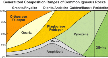
Diagram of igneous rocks as identified by their present minerals. Image courtesy of Geology.com.
For the rocks in the three leftmost columns, there are two rocks each. These identify the course grained rocks (granite, diorite, and gabbro), that formed as intrusive igneous rocks. This means that they formed from a body of magma (molten rock) that cooled over a very long time underground. This allowed the crystals to grow to a point where individual crystals are easily identifiable by the naked eye. The second set of rocks are for the fine grained rocks (rhyolite, andesite, basalt). These rocks are extrusive igneous rocks, also known as volcanic. These rocks formed from lava (magma that had been erupted), and cooled very quickly. The quick cooling caused the mineral grains to be very small and mostly unobservable to the naked eye.
When you look at the rock groupings from left to right there are certain patterns. One is that the amount of silica (quartz) decreases. There is also less Orthoclase Feldspar are you move to the right. These are both generally light colored minerals. The minerals more on the right (plagioclase, pyroxene, micas, and amphibole), these are generally more darker colored minerals. So as you move from left to right, the rocks get darker in color.

A "black granite", aka Swedish diabase from Scandinavian Stone's Gylsboda Quarry. Image courtesy of Scandinavian Stone.
The use of the term "black granite" already had me questioning if this was a real thing. However, after doing some research it appears the term "black granite" is applied to rocks that "share the hardness and strength" of granitic rocks, despite them not actually being a granite. Generally, these "black granites" are what are known as a diabase (also known as dolerite), which is a microcrystalline gabbro with crystal sizes (and therefore cooling rates) falling in between gabbro and basalt.
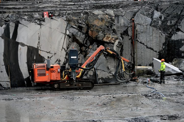
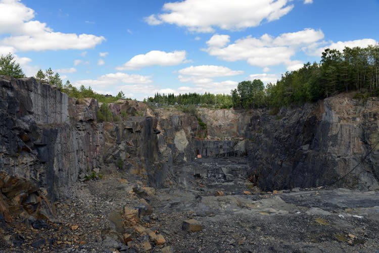
Globally, Sweden isn't generally known for their building stones. However, that doesn't mean that Sweden should be ignored. They actually have a significant amount of building stones that they frequently will quarry and send off to other countries, such as Italy, Spain, China, or Poland for processing. The size of the industry in Sweden is very small though, totaling ~1,200 people with three separate companies comprising the bulk of that number.
Diabase from the Swedish Gylsboda Quarry. Image courtesy of Scandinavian Stone.
Within Sweden, there three main rocks that are quarried, among them several varieties of "black granite" AKA diabase. This includes the rock types known in the construction industry as Black Bonnacord, Black Finegrained variety, Black Ebony, Black Gylsboda, and Grey Bohus. The problem with these industry names though is that they more reference the color and texture of the rock and not any particular geological occurrence. I actually found one quarry (Black Diabase Brannhult Quarry) That has several of these types of rocks all listed within the same quarry, further emphasizing that these are likely variations on the same rock formation.
Diabase from the Swedish Hjortsjö Quarry. Image courtesy of Scandinavian Stone.
But the one thing I did find, is that many of the diabase quarries were in the south central part of Sweden, in the region called Småland (which is not only the name of the Ikea day care apparently). Looking at the geologic map below the southern portion of Sweden can be broken down into two distinct provinces, the eastern province known as the Transcandinavian Igneous Belt and the western province known simple as the Eastern Segment.
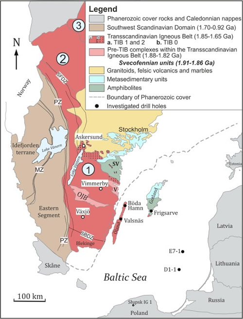
Southern Sweden geology. Image courtesy of Salin et al., 2019.
The problem is that many of the quarry locations are falling very close to that central area between the two provinces known as the Protogine Zone, which is a major faulted shear zone. However, upon closer inspection, it appears that these quarries, which all are within a generally small region, are a part of the Transcandinavian Igneous Belt within an area known as the Småland-Värmland granitoids.
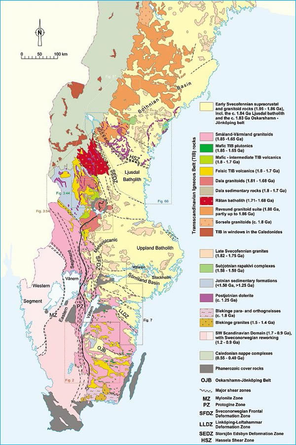
More detailed southern Sweden geologic map. Image courtesy of Högdahl et al., 2004.
The above geological map indicates that these diabase deposits are dated to around 1.85 to 1.65 billion years old. However, diabase, is often deposited as smaller igneous bodies within a larger body, such as a sill, dike, lopolith, or a laccolith. The smaller igneous body allows for some slow cooling, but not slow enough to form a full on gabbro. Therefore the dates on these larger bodies is likely too old and the actual diabase would be younger than that. However, I don't think they would be too much younger since the magmas that formed the larger Transcandinavian Igneous Belt are likely related to the diabase producing magmas.
On the map above it also lists some other provinces of dolerite (the other name for diabase) towards the northern end of this region. The quarries that I researched are not harvesting this diabase, but that doesn't mean that another company isn't. This diabase is dated to 1.25 billion years old and I would image the diabase in the southern portion of the country would date around the same.
So in general, the "Swedish black granite" mentioned in the text was likely obtained from these southern diabase deposits within the Småland-Värmland granitoids. It also works out that since these are along the southern coast of Sweden, the transportation distance to Poland would have been much less across the Baltic Sea to the east.
References
https://www.litosonline.com/en/article/stone-industry-sweden
https://geology.com/rocks/diabase.shtml
https://geology.com/rocks/diorite.shtml
https://www.stonecontact.com/quarries-1278/black-diabase-brannhult-quarry
https://www.sciencedirect.com/science/article/abs/pii/S0301926818306569
https://tupa.gtk.fi/julkaisu/specialpaper/sp_037.pdf
The Periodic Table by Primo Levi

The Periodic Table was a rich experience with the author, Primo Levi, recounting several stories within his life through the framework of elements on the Periodic Table, hence the name of the book. But here we are interested in the "geology" through literature, not chemistry, so what does this book have to offer us? Quite a bit actually. Here are some of the more geological sections.
First Chapter - Argon
"...[this] Piedmontese dialect, never written except on a bet, and the Hebrew inlay, snatched from the language of the fathers, sacred and solemn, geologic, polished smooth by the millennia like a bed of a glacier."
Although there are known instances where glaciers have moved quickly, they are generally known to have a slow pace to them. Hence the term "glacial" meaning slow. But over time, as the glacier moves, the base of the glacier defrosts and refreezes continually. This defrosting and freezing causes the base of the glacier to pick up various pieces of rocks, gravels, sand, and rock powder. These pieces of the landscape are then forced downwards by the weight of the overlying ice, which can sometimes reach many miles in thickness. These rock pieces, that are being forced downwards as the glacier moves forward, have the effect of acting like sandpaper on the surface of the Earth, slowly polishing the bedrock smooth. Over time that smoothness is ground down finer and finer. This polishing effect also produces powered rock known as glacial flour, just like sandpaper does to a piece of wood.
Sixth Chapter - Nickel
"Yes, all mines are magical per se, and always have been. The entrails of the earth swarm with gnomes, kobolds (cobalt!), nickel, German 'little demon' or 'sprite,' and from which we derive the word nickel, creatures who can be generous and let you find a treasure beneath the tip of your pickax, or deceive and bedazzle you, making modest pyrites glitter like gold, or disguising zinc in the garb of tin: and in fact, many are the minerals whose names have roots that signify 'deception, fraud, bedazzlement.'"
This passage is interesting because it touches on a couple of different aspects of minerals. One is their sometimes resemblance to other, more or less important minerals. And the other is the naming of the minerals, which sometimes goes so far back in history that their original names don't have any direct correlation with what they are known for today.
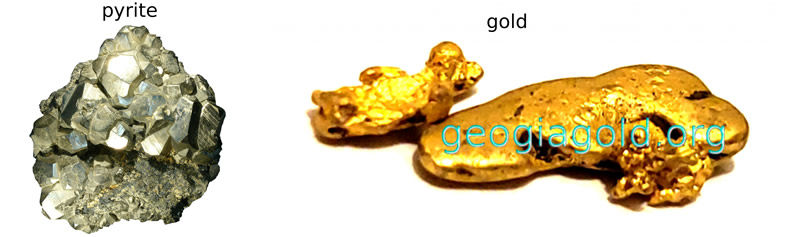
One of the most commonly misidentified minerals would probably be pyrite for gold. Pyrite, often known as "fool's gold", has a strong gold colored metallic luster to it, where people are immediately drawn to assume it is gold. Pyrite is actually a fairly common mineral, especially when compared to the far more valuable and elusive gold. Pyrite is made up of iron and sulfide (FeS2), while gold is just made up of elemental gold (Au). The name "Pyrite" comes from the Greek word "Pyr", which means "fire". The name comes from the fact that when it was struck with an iron tool back in ancient times it emitted sparks.
The name of the mineral cobalt originally came from the German word for goblin or devilish spirit, kobold. Around 1500 AD (BCE), German miners were mining for silver when they came across this substance, which looked like silver but did not act like silver. And to top it off, when they tried to melt it down it gave off noxious fumes, which caused the miners to get sick and sometimes die. They attributed it to goblins having bewitched the silver ore causing the noxious fumes. One of the problems was that the primary metals known at the time: gold, silver, copper, iron, tin, lead, and mercury, were the only known metals since ancient times and the miners had no concept that new metals could even exist. In the 1730's a Swedish chemist, Georg Brandt, was able to isolate the metal and ended up using the same name that the German miners had branded it with.
In the 1600's the Germans were at it again. This time miners were searching for copper and came across this brownish-red rock that they believed was copper. However, when they tried to extract the copper from the rock they were unsuccessful. They ended up blaming "Nickel" for the lack of copper, who was a mischievous German demon. They called the ore kupfernickel, which means "copper demon". In 1751, another Swedish scientist, Baron Axel Fredrik Cronstedt, was able to extract the nickel from the kupfernickel ore, which was a mixture of arsenic and nickel. He ended up dropping the first part of the name and kept the "nickel" part as the name of the element and mineral.
Eighth Chapter - Mercury
"That very evening just before nightfall, we heard a great rumble of thunder, as though the island itself was being shaken to its roots. In a few minutes the sky darkened and the black cloud that covered it was lit from below as by a fire. From the top of Mount Snowdon we saw first rapid red flashes leap out and climb up into the sky, then a broad, slow stream of burning lava: it did not descend toward us but to the left, the south, pouring from ridge to ridge, hissing and crackling. After an hour it reached the sea and there it was doused with a roar, lifting up a column of vapor. None of us had ever thought that Mount Snowdon could be a volcano; and yet the shape of its summit, with a round hollow at least two hundred feet deep, could have made us us suspect this.
The spectacle continued all through the night, calming down every so often, then picking up again with a new series of explosions; it seemed that it would never end. Yet, toward dawn, a hot wind blew from the east, the sky cleared off again, and the uproar gradually died down until it was reduced to a murmur, then silence. The mantle of lava, which had been yellow and dazzling, turned reddish like smoldering coals, and by daylight it was extinguished."
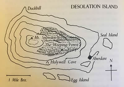
Map of Desolation Island highlighting Mount Snowdon from The Periodic Table
Unfortunately, Desolation Island, and the mysterious volcano Mount Snowdon, were both made up for the story. I had hopes that they would really exist given the autobiographical nature of the rest of the story, however this chapter was one based entirely in fiction. The original Mount Snowdon, the one from which the story's volcano was named, was formed during the Ordovician period (450 million years ago) along a prehistoric convergent plate boundary in what is now Whales. A convergent plate boundary is when one plate was forced down underneath another plate. This caused the lower plate (the one going down into the Earth) to melt. The liquid rock, magma, then slowly rose over time and ended up forming volcanoes, like the aforementioned Mount Snowdon (the real one). The real Mount Snowdon however has long been an extinct volcano and has been eroding ever since.
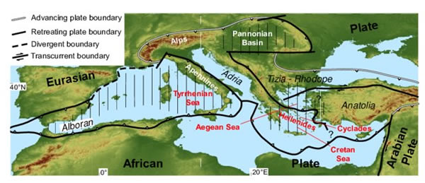
Although it is never spelled out, there are a couple of locations for which the island could be located. One of those is the Mediterranean based on the eruption style. Within the Mediterranean you have an over abundance of islands, many of which are either volcanoes or volcanic in origin. This is because you have the same situation as the formation of Mount Snowdon (the real one). There are numerous subduction zones, creating numerous volcanoes across the region, specifically in Italy and Greece. These volcanoes form as the subducted plate starts to melt and that melted plate material, the magma, rises up through the crust. Eventually, as more and more magma builds up, the pressure builds up and the volcano erupts. When the magma moves through continental crust it picks up more silica based minerals, which melt at a lower temperature and produce more explosive eruptions, like the ones seen from Mount Vesuvius. The story of Mount Vesuvius/Pompeii is very reminiscent of the story that Levi told in the The Periodic Table with lava and ash clouds erupting from an unknown volcano.
However, Levi points out at the beginning of the chapter that Desolation Island is located 1,200 miles to the southeast from an island known as St. Helena. St. Helena is actually a real volcanic island that is located in the middle of the southern Atlantic Ocean. It's claim to fame is that it was the location of Napoleon's final exile/imprisonment and where he eventually died. Although the island is a volcano, it's last eruption was 7 million years ago, when the island was situated along the Mid-Atlantic Ridge. The Mid-Atlantic Ridge is a divergent plate boundary, which means that two plates are pulling apart from each other. This pull-apart results in a very long volcanic mountain chain located beneath the oceanic surface. While most of the volcanoes remain below the surface of the ocean, some do break the surface, with St. Helena being one of those examples. Eventually the island moved along with the plate as the plate spread out from the divergent plate boundary. This movement moved the volcano away from its source of magma, making it an extinct volcano, likely never to erupt again. The type of eruption that came from St. Helena would be vastly different than the one from Pompeii as well. While Pompeii would contain an explosive eruption with lots of ash and volcanic gasses and clouds, St. Helena would more resemble a Hawaiian eruption, with a steady stream of low-viscosity lava and very little clouds.
References
https://www.georgiagold.org/2018/08/05/pyrite-vs-gold-how-to-spot-the-difference/
https://www.sciencefriday.com/articles/the-origin-of-the-word-cobalt/
https://www.livescience.com/29327-nickel.html
https://www.walesonline.co.uk/news/local-news/seen-last-snowdons-volcanic-past-1826956
https://volcanocafe.wordpress.com/2013/01/01/mt-snowdon/
http://sainthelenaisland.info/geology.htm
Leaves of Grass by Walt Whitman
 Leaves of Grass by Walt Whitman exudes beautiful descriptions of the natural environment around all of us. This includes many geological terms being thrown about such as "gneiss" and "coal". Without any context though, those words are just ... words. But there is one line that provides a great geological context:
[Song of Myself]
"...In vain the plutonic rocks send their old heat against my approach..."
Although this is a simple line, it actually provides a great deal of insight. Plutonic rocks are a variety of igneous rocks. Igneous rocks are a type of rock that forms from molten/liquid rock. There are two main varieties of igneous rocks. They are known as external igneous rocks and internal igneous rocks. External igneous rocks, also known as volcanic rocks, form from molten rock that has erupted to the surface of the earth (i.e. lava) and solidifies there. These types of rocks have no visible crystals within them because they cool so quickly.
Internal igneous rocks, also known as plutonic rocks, form from molten rock that has not erupted to the earth's surface and remains within the earth (i.e. magma). Since these rocks cool within the earth they cool a lot slower allowing the crystals within them to grow much larger than volcanic rocks. Granite is a common type of internal igneous rock. The earth provides a type of blanket to these molten rocks allowing the heat to remain within them for a lot longer. This leads to the "old heat" reference in the text from the plutonic rocks.
Dragon Teeth by Michael Crichton
 Dragon Teeth had come across my radar for my work through AiPT Comics. I had initially done a joint review for the book with fellow reviewer and fellow dinosaur fanboy, Robert Reed. Dragon Teeth is the latest book that has come out by Jurassic Park author Michael Crichton. However, Crichton has been dead for some time before the publication of this book so it is unknown how much reworking and polishing was needed by other people before the book had been put to print. Dragon Teeth takes place during the tumultuous times in early paleontology during a period termed the "Bone Wars". When giants in the field Othniel C. Marsh and Edward Drinker Cope, would have their minions literally battling it out over fossils or destroying scientifically irreplaceable specimens in the goal to prevent the other from obtaining them. It is during this time period that we have Dragon Teeth taking place, an entirely fictional novel, although presented as if it were a historical reenactment.
Dragon Teeth takes place in 1876 and follows a rich, but lazy, student William Johnson, at Yale University who ends up with a bet that he would never be able to survive a trip to the west. In response to the bet, Johnson declares that he was already involved with the expedition west led by Marsh, a professor at Yale. Despite his boast, Johnson had nothing to do with the expedition but he managed to weasel his way in by saying he was a photographer. After months of training to actually be a photographer, the expedition sets off for the west, without the participants having any real idea as to where they were going.
There are quite a few instances of paleontology and geology that are mentioned throughout the novel, however there are not as many as you would expect given the subject. I found that reading The Life of a Fossil Hunter in conjunction with Dragon Teeth gave me a much better understanding for both books, the real life adventure and the fictional one based on real events. Here are a few of the geological and paleontological mentions that I would like to highlight and discuss.
Part 1: Second Chapter - Marsh
(there are no chapter numbers)
"Marsh led him back into the interior of the museum. The air was chalky and shafts of sunlight pierced it like a cathedral. In a vast cavernous space, Johnson saw men in white lab coats bent over great slabs of rock, chipping bones free with small chisels. They worked carefully, he saw, and used small brushes to clean their work. In the far corner, a gigantic skeleton was being assembled, the framework of bones rising to the ceiling.
"Giganthopus marshiensis, my crowning achievement," Marsh said, nodding toward the looming beast of bones. 'To date, that is. Discovered her in '74, in the Wyoming Territory. I always think of her as her.'"
From what I can tell, there is no dinosaur with the genus Giganthopus, nor has there ever been. This appears to be an MO with Crichton, which is to mix seemingly plausible scientific names with actual scientific names. The reason for the mixed occurrences is unknown to me. However, since there is enough material in the text to speculate what Crichton could mean, let us do that. He says that the dinosaur in question was discovered in the Wyoming Territory in 1874, which at that time the boundaries were identical to the finalized state of Wyoming. Knowing how quickly Marsh was able to turn around a fossil from discovery to naming of the dinosaur, this means that the dinosaur could have been one that Marsh named in 1874, 1875, or 1876. Even though the story takes place in 1876, we could fudge that 1876 date a bit.
Within the text we know that the dinosaur Marsh is referring to was big, a "looming beast of bones". We also know that it had enough of a skeleton that it could be reconstructed. This leaves us with a few dinosaurs that Marsh had discovered including Allosaurus, which was named by Marsh in 1877 and discovered in central Colorado. However, there were not many bones from the initial discovery of Allosaurus to piece together a "looming beast". The Apatosaurus was named in 1877 and discovered in Colorado, however it was based on a nearly complete specimen. Diplodocus was found and named shortly after this in 1877, also found in Colorado. And one more potential dinosaur, although I wouldn't consider it "looming", was Stegosaurus, named in 1877 and found, again, in Colorado. So even though all of these are named after the text, it is logical that the papers could have been in the works. The biggest glaring error with these was that Marsh would clearly have known the difference between Colorado and Wyoming, which all of his major dinosaur finds at the time were coming out of.
Part 1: Sixth Chapter - Chicago
"Then, too, Chicago reporters never tired of repeating the story of Marsh's earliest public exploit, the affair of the Cardiff giant.
In 1869, the fossilized skeleton of a ten-foot giant was unearthed in Cardiff, New York, and quickly became a national phenomenon. It was generally agreed that the giant was one of a race of men who had been drowned in Noah's flood; Gordon Bennett of the New York Herald and a number of scholars had pronounced it genuine.
Marsh, in his capacity as the new paleontology professor from Yale, went to view the fossil and said, within earshot of a reporter, 'Very remarkable.'
'May I quote you?' said the reporter.
'Yes,' said Marsh. 'You may quote me as saying, 'A very remarkable fake.'
It was later determined that the so-called giant originated as a block of gypsum, carved secretly in Chicago."
Unlike the encounter previously mentioned, this one actually did occur, and nearly identical to how it is presented here. From History.com, the Cardiff giant was a phenomenal hoax of the time. In an attempt to discredit a preacher, George Hull came up with the idea of creating a "petrified man" by carving one out of gypsum and burying him.
The gypsum came from Fort Dodge, Iowa. The gypsum in question was from the Jurassic, Fort Dodge Formation. Gypsum is an evaporate mineral, formed in much the same way as salt deposits form, except in water that has a high sulfur content. Gypsum is white to grey in color and is extremely soft, being able to be scratched by a fingernail. So, although it would would be quick and easy to make a statue out of, the statue itself would not last long, especially buried in the wet soil of upstate New York. Many people noticed this and questioned the statues legitimacy.
And it was indeed Marsh, who upon seeing the statue said that it was “of very recent origin, and a most decided humbug.”
Part 2: Eighteenth Chapter - Bone Country
The following series of entries is actually one continuous passage that presents a pretty accurate look at the early history of the science of paleontology.
"In 1876, scientific acceptance of dinosaurs was still fairly recent; at the turn of the century, men did not suspect the existence of these great reptiles at all, although the evidence was there to see.
Back in July 1806, William Clark, of the Lewis and Clark Expedition, explored the south bank of the Yellowstone River, in what would later become Montana Territory, and found a fossil 'semented [sic] within the face of the rock.' He described it as a bone three inches in circumference and three feet in length, and considered it the rib of a fish, although it was probably a dinosaur bone."
Northeast of Billings, Montana lies a promontory of sandstone along the Yellowstone River known as Pompey's Pillar, now designated a National Monument. It was near here that Clark truly did find a fossil within the face of a rock on July 25th, 1806. His description of the find went almost identical to Crichton's recount:
“…I employed myself in getting pieces of the rib of a fish which was cemented within the face of the rock. This rib is about 3 inches in circumference about the middle. It is 3 feet in length though part of the end appears to have been broken off. I have several pieces of this rib. The bone is neither decayed nor petrified but very rotten.”
Although he thought it was a fish rib, paleontologists now suspect a dinosaur bone, perhaps a Hadrosaurus, Triceratops, or Tyrannosaurus, all of which have been found in the nearby sediment.
"More dinosaur bones were found in Connecticut in 1818; they were believed to be the remains of human beings..."
What is generally assumed to be the first discovery and collection of dinosaur bones in North America was in Connecticut in 1818. Fossilized bone fragments were found within Late Triassic red sandstones while blasting a well near Ketch's Mills in East Winsor. The bones were discovered by Solomon Elsworth Jr. who gave them to some professors at the Medical Institute of Yale University. The professors thought that the bones might be human remains, however they couldn't be certain. Later studies and descriptions of the bones allowed them to be named a new species of prosauropod, Anchisaurus colurus (Lull, 1912), which was later renamed Anchisaurus polyzelus (Galton, 1976).
"...dinosaur footprints, discovered in the same region, were described as the tracks of 'Noah's raven.'"
I had broken down the Noah's raven tracks previously as part of my DINOS! From Cultural to Pop Culture series. In short, the story goes back to 1802, when a young boy named Pliny Moody, was farming his fields in South Hadley, Massachusetts. While he was plowing, he unearthed a rock slab with a bunch of weird markings across it. He took the slab home and set it as a doorstep, because that's apparently what you did with these things back then (Nash Dinosaur Track Site). In 1810, the house, along with the rock, was sold to Dr. Elihu Dwight, who lived there for 30 years. During this time, the markings on the rocks were "identified" as the tracks of "Noah's Ravens". The term "Noah's Ravens" refers to the birds that were sent by Noah to find dry land during the flood. The raven never returned to the ark and it was thought that these footprints represented the location where the raven touched down onto Earth following the floods. These tracks were later seen by famed ichnologist Edward Hitchcock, who identified them as bird tracks. Later scientists came back to the tracks and realized that they were really dinosaur tracks.
"The true meaning of these fossils was first recognized in England. In 1824, an eccentric English clergyman named Buckland described 'the Megalosaurus or Great Fossil Lizard of Stonesfield.' Buckland imagined the fossil creature to be more than forty feet long, 'and with a bulk equal to that of an elephant seven feet high.' But this remarkable lizard was considered an isolated specimen."
In 1824, William Buckland was the first person to describe and validly name a dinosaur species (although it wasn't known as a "Dinosaur" at the time). The paper in which Buckland described the specimen was titled "Notice on the Megalosaurus or Great Fossil Lizard of Stonesfield". His identification and descriptions were based on the lower jaw, some teeth, some vertebrae, pieces of ribs, and some other bones. Based on these pieces of evidence Buckland said that Cuvier placed animals with these sized bones to be as big as 40 feet in length and weigh as much as an elephant seven feet high. Buckland seemed hesitant to place those exact dimensions on this animal but he did accede that this animal had to have been larger than any currently living animal.
"The following year, Gideon Mantell, an English physician, described 'Iguanodon, a newly-discovered Fossil Reptile.' Mantell's description was based largely on some teeth found in an English quarry. Originally the teeth were sent to Baron Cuvier, the greatest anatomist of his day; he pronounced them the incisors of a rhinoceros. Dissatisfied, Mantell remained convinced that 'I had discovered the teeth of an unknown herbivorous reptile,' and eventually demonstrated that the teeth resembled those of an iguana, an American lizard."
In 1822, Mary Ann Mantell stumbled upon a tooth unlike anything they had ever seen before. She presented the tooth to her husband, Gideon, a physician who had an interest in fossils. Gideon was able to trace the tooth back to its source and discovered several other teeth as well as some other bones. Not only did he send the bones to Cuvier as described above but he also sent them to the aforementioned William Buckland. Cuvier suggested it was a rhinoceros and Buckland said is was from a large fish and advised not to pursue it any more. Dr. Mantell would not be dissuaded and upon visiting the Royal College of Surgeons in London he was shown a specimen of an iguana, brought back from the West Indies by Darwin. Looking at the teeth, Dr. Mantell noticed the extreme similarity between the two, except his was much, much larger, and identified the tooth as belonging to a giant extinct reptile. He eventually published on the specimen in 1825 in a journal article entitled "Notice on the Iguanodon, a newly discovered fossil reptile, from the sandstone of Tilgate Forest, in Sussex".
"Baron Cuvier admitted his error, and wondered: 'Do we not have here a new animal, an herbivorous reptile ... of another time?' Other fossil reptiles were unearthed in rapid succession: Hylaeosaurus in 1832; Macrodontophion in 1834; Thecodontosaurus and Paleosaurus in 1836; Plateosaurus in 1837. With each new discovery came the growing suspicion that the bones represented a whole group of reptiles that had since vanished from the earth."
Gideon Mantell went on from his initial publication on Iguanodon to discover and describe several others of the initial dinosaur publications including Hylaeosaurus (1832) and Peleosaurus (1850). Mantell acquired a series of bones from a gunpowder explosion at a mine in West Sussex in 1832. The bones, Mantell realized, could be reassembled to form a partial skeleton. After being advised that this wasn't just another example of his previous find, Iguanodon, he decided to publish his find under the name Hylaeosaurus, which became the first named and identified anklyosaur.
Macrodontophion is a dubious animal since it was initially described by A. Zborzewski from a single "tooth" from the "Jurassic redbeds" of southern Russia. However both the age of the fossil and the identification of it as a tooth have been called into question.
Thecodontosaurus was initially discovered in 1834 in one of Bristol's limestone quarries. The initial discovery of the bones led to a race between two groups of researchers with Samuel Stutchbury and Henry Riley coming out on top describing and naming what will eventually be identified as an early sauropodomorph. Although not officially published on until 1840, an abstract for a talk with the name and short description of the fossils in 1836 was enough to solidify that date as the fourth named dinosaur specimen.
Paleosaurus was also named in the same abstract as Thecodontosaurus by Riley and Stutchbury based on two fossil teeth. Neither Thecodontosaurus or Paleosaurus were identified as part of Dinosauria, when "Dinosauria" was officially named, because they were dubious specimens at the time. It wasn't until several years later they were reevaluated and found to truly represent dinosaurs.
Plateosaurus was initially found in Heroldsberg, Germany by physician Johann Friedrich Engelhardt in 1834. The discovery, which consisted of some vertebrae and leg bones was eventually described and named by paleontologist Hermann von Mayer in 1837. Although not thought of as a dinosaur at the time due to the scant remains that initially identified it, Plateosaurus has since become one of the most abundant dinosaur discoveries in history with well over 100 known skeletons.
"Finally, in 1841, another physician and anatomist, Richard Owen, proposed the entire group be called Dinosauria, or 'terrible lizards.'"
Even though there were many potential "dinosaur" discoveries up until this point, many of them were not recognized as being dinosaurs until reevaluations much later. It is for that reason that Sir Richard Owen only used three particular species to identify his new characterization of "Dinosauria". As I go into more detail here, in 1841, Owen identified common characterizations that Megalosaurus, Iguanodon, and Hylaeosaurus contained. Mainly that they had columnar legs instead of the sprawling gait of crocodilians, and vertebrae fused to the pelvis. It was from these characterizations that he gave the following comments in a talk, which were later published,
"The combination of such characters, some as the sacral ones, altogether peculiar among reptiles, others borrowed, as it were, from groups now distinct from each other, and all manifested by creatures far surpassing in size the largest of existing reptiles, will, it is presumed, be deemed sufficient ground for establishing a distinct tribe or suborder of saurian reptiles, for which I would propose the name of Dinosauria."
And the continuous passage ends with the following:
"The notion became so widely accepted that in 1854, full-sized reconstructions of dinosaurs were built in Crystal Palace in Sydenham, and attained wide popularity with the public."
There is a place called the Crystal Palace located in Sydenham Hill that was constructed over a period of time from 1853 to 1855. The Crystal Palace is still around today and remains largely as it was when the park opened in 1854. For the dinosaurs, sculptor Benjamin Waterhouse Hawkins, examined the fossils and conferred with Richard Owen, predominant paleontologist, to present the most accurate reconstruction of dinosaurs at the time.
With that history of paleontology laid out, the text continues on with the story. The next paleontological point of interest comes up later in the same chapter.
"But the rock was fragile, and breaks in the fossils did occur, even with the most careful handling. Most frustrating of all was a break days or weeks after the fossil was lowered to the ground.
It was Sternberg who first proposed a solution.
When they set out from Fort Benton, they had brought with them several hundred pounds of rice. As the days went on, it became clear that they would never eat all the rice ('at least not the way Stinky cooks it,' Isaac grumbled). Rather than leave it behind, Sternberg boiled the rice to a gelatinous paste, which he poured over the fossils. This novel preservative technique left the fossils looking like snowy blocks-or, as he put it, 'gigantic cookies.'
But whatever they called it, the paste provided a protective covering. They had no further breaks."
 This is one of the hallmarks of dinosaur excavation today, wrapping the fossils to protect them from damage, while trying to remove them from the rock, or remove the rock all together with the fossils embedded inside the blocks. The process is known as making a fossil field jacket and involves using burlap and plaster of Paris, along with other materials to stabilize the fossils such as pieces of wood and tissue paper or aluminum foil to protect the fossils. But that is the process we use today in the field. What about before all of that was invented? I went back to the source of the information to what ended up being a great tie-in book for Dragon Teeth, Sternberg's autobiography itself, The Life of a Fossil Hunter, in which he describes the fossil jacket creation process. Even though Crichton's main character in Dragon Teeth, William Johnson, was a complete fabrication, many of the people in the book were not, including Charles Sternberg. Here is Sternberg's own account of the situation, when he was indeed out in the field with Cope:
"When we uncovered these bones [from a Monoclonius sphenocerus] we found them very brittle, as they shattered by the uplift of the strata in which they were buried; and we were obliged to devise some means of holding them in place. The only thing we had in camp that could be made into a paste was rice, which we had brought along for food. We boiled quantities of it until it became thick, then, dipping into it flour bags and pieces of cotton cloth and burlap, we used them to strengthen the bones and hold them together. This was the beginning of a long line of experiments, which culminated in the recently adopted method of taking up large fossils by bandaging them with strips of cloth dipped in plaster of Paris, like the bandages in which a modern surgeon encases a broken limb."
Part 2: Nineteenth Chapter - Around the Fire
"Unlike Marsh, Cope was not an open Darwinian, but he appeared to believe in evolution, and certainly in great antiquity. Morton was going to be a preacher, like his father. He asked Cope, 'as a man of science,' how old the world was.
Cope said he had no idea, in the mild way he had when he was concealing something. It was the opposite side of his snapping temper, this almost lazy indifference, this tranquil, calm voice. This mildness overcame Cope whenever the discussion moved into areas that might be considered religious. A devout Quaker (despite his pugilistic temperament), he found it difficult to tread on the religious feelings of others.
Was the world, Morton asked, six thousand years old, as Bishop Ussher had said?
A great many serious and informed people still believed this date, despite Darwin and the fuss that the new scientists who called themselves 'geologists' were making. After all, the trouble with what the scientists said was that they were always saying something different. This year one idea, next year something else. Scientific opinion was ever changing, like the fashions of women's dress, while the firm and fixed date 4004 BC invited the attention of those seeking greater verity.
No, Cope said, he did not think the world was so recent.
How old, then? asked Morton. Six thousand years? Ten thousand years?
No, Cope said, still tranquil.
Then how much older?
A thousand thousand times as old, said Cope, his voice still dreamy.
'Surely you're joking!' Morton exclaimed. 'Four billion years? that is patently absurd.'
'I know of no one who was there at the time,' Cope said mildly.
'But what about the age of the sun?' Morton said, with a smug look.
In 1871, Lord Kelvin, the most eminent physicist of his day, posed a serious objection to Darwin's theory. It had not been answered by Darwin, or anyone else, in subsequent years.
Whatever else one might think of evolutionary theory, it obviously implied a substantial period of time-at least several hundred thousand years-to carry out its effects on earth. At the time of Darwin's publication, the oldest estimates of the age of the earth were around ten thousand years. Darwin himself believed the earth would have to be at least three hundred thousand years old to allow enough time for evolution. The earthly evidence, from the new study of geology, was confusing and contradictory, but it seemed at least conceivable that the earth might be several hundred thousand years old. Lord Kelvin took a different approach to the question. He asked how long the sun had been burning. At this time, the mass of the sun was well established; it was obviously burning with the same processes of combustion as were found on earth; therefore one could estimate the time it would take to consume the mass of the sun in a great fire. Kelvin's answer was that the sun would burn up entirely within twenty thousand years.
...
Corroborating evidence derived from the warmth of the earth. From mine shafts and other drilling, it was known that the earth's temperature increased one degree for every thousand feet of depth. This implied that the core of the earth was still quite hot. But if the earth had really formed hundreds of thousands of years ago, it would have long since become cool. That was a clear implication of the second law of thermodynamics, and there was no disputing it.
There was only one escape from these physical dilemmas, and Cope echoes Darwin in suggesting it, 'Perhaps,' he said, 'we do not know everything about the energy sources of the sun and the earth.'
'You mean there may be a new form of energy, as yet unknown to science?' Morton asked. 'The physicists say that it is impossible, that the rules governing the universe are fully understood by them,'
'Perhaps the physicists are wrong,' Cope said.
'Certainly someone is wrong.'
'That is true,' Cope said evenly.
I had previously given a brief brake down of the historic calculations for the age of the Earth, including Bishop Ussher and Lord Kelvin's contributions on my Geology Through Literature post on Good Omens. Generally Crichton is correct here but he does have some errors mixed into the text as well. In the 1600's Lord Ussher did indeed determine the age of the Earth to be approximately six thousand years old, being "born" on 4004 BC.
This was the predominant theory of the time. However scientists started to come around to question that age. Specifically, in the late 1700's, James Hutton produced his principle of uniformitarianism which said that everything happening today has happened in the past, and at a similar rate. So, even though Hutton didn't give a specific age of the Earth, he did place a timescale on it, saying that the earth had to be hundred of millions or even billions of years old.
Following Hutton within the 1800's, scientists were all over the place trying to use his theory, along with rates of sedimentation and erosion, to pinpoint a date. As Crichton said above, they really were not able to place an exact date and would frequently come up with widely contradictory dates. Darwin himself did weigh in on the debate. Within The Origin of Species, Darwin mentioned several time estimates for different periods of the Earth, all of which would insinuate that he thought the Earth was much older then the 300,000 years that Crichton thought he believed in, and it was actually more like 300 million years. From the first edition (1859) of On the Origin of Species Darwin wrote "So that in all probability a far longer period than 300 million years has elapsed since the latter part of the Secondary period." He goes into much more detail in later versions. In the sixth edition (1872) he wrote:
"Consequently, if the theory be true, it is indisputable that before the lowest Cambrian stratum was deposited long periods elapsed, as long as, or probably far longer than, the whole interval from the Cambrian age to the present day; and that during these vast periods the world swarmed with living creatures. Here we encounter a formidable objection; for it seems doubtful whether the earth, in a fit state for the habitation of living creatures, has lasted long enough. Sir W. Thompson concludes that the consolidation of the crust can hardly have occurred less than twenty or more than four hundred million years ago, but probably not less than ninety-eight or more than two hundred million years. These very wide limits show how doubtful the data are; and other elements may have hereafter to be introduced into the problem. Mr. Croll estimates that about sixty million years have elapsed since the Cambrian period, but this, judging from the small amount of organic change since the commencement of the Glacial epoch, appears a very short time for the many and great mutations of life, which have certainly occurred since the Cambrian formation; and the previous one hundred and forty million years can hardly be considered as sufficient for the development of the varied forms of life which already existed during the Cambrian period. It is, however, probable, as Sir William Thompson insists, that the world at a very early period was subjected to more rapid and violent changes in its physical conditions than those now occurring; and such changes would have tended to induce changes at a corresponding rate in the organisms which then existed."
Here Darwin highlighted the extreme inconsistencies with age dating at the time, which relied heavily on non-specific geological processes such as erosion and deposition.
In the 1860's, Lord Kelvin came into the mix. Lord Kelvin was a predominate expert in thermodynamics at the time. He based the age of the earth on the rate of cooling that the Earth needed to experience based on its size and current temperature. This led Lord Kelvin to estimate an age of the Earth in the range of 20-100 million years, eventually bringing that high number down to a range of 20-40 million years. Kelvin's biggest shortcoming was that he was indeed unaware of a different source of energy in the Earth. Following Lord Kelvin's estimates by about 30 years was the discovery of radioactivity. It was the energy and heat released by radioactivity that has kept the Earth a lot warmer than it normally would have been. This energy was what completely nullified Lord Kelvin's estimates.
Part 2: Twenty-first Chapter - Dinner with Cope and Marsh
"Cope was busy with preparations of his own. His picked through the piles of fossils they had found, selecting a piece here, a piece there, setting them aside.
Johnson asked if he could help, but Cope shook his head. 'This is a job for an expert.'
'You are selecting finds to show Marsh?'
'In a way. I am making a new creature: Dinosaurus marshiensis vulgaris.'
By the end of the day he had assembled from fragments a passable skull, with two horned projections that stuck out laterally from the jaw like curving tusks.
Isaac said it looked like a wild boar, or a warthog.
'Exactly,' Cope said, excited. 'A prehistoric porcine giant. A piglike dinosaur! A pig for a pig!'
Needless to say but there has never been a dinosaur named with the genus of Dinosaurus. Although there is apparently a movie.
The name and the description were all entirely made up for the book, and they were even made up in the book.
Part 2: Twenty-fourth Chapter - The Teeth
"'...I want a picture in situ. [said Cope]'
'Of these rocks?' Johnson asked, astonished.
'Rocks? You think these are rocks? They are nothing of the sort.'
'Then what are they?'
'They are teeth!' Cope exclaimed....
'Teeth,' he repeated. 'Dinosaur teeth.'
'But they are enormous! This dinosaur must be of fantastic size'
For a moment the two men silently contemplated just how large such a dinosaur must have been-the jaw needed to hold rows of such large teeth, the thick skull needed to match such a massive jaw, the enormous neck the width of a stout oak to lift and move such a skull and jaw, the gigantic backbone commensurate to the neck, with each vertebra as big around as a wagon wheel, with four staggeringly huge and thick legs to support such a beast. Each tooth implied an enormity of every bone and every joint. An animal that large might even need a long tail to counterweight its neck, in fact.
...
Cope measured the teeth with his steel calipers, scratched some calculations on his sketch pad, and shook his head. 'It doesn't seem possible,' he said, and measured again. And then he stood looking across the expanses of rock, as if expecting to see the giant dinosaur appear before him, shaking the ground with each step. 'If we are making discoveries such as this one,' he said to Johnson, 'it means that we have barely scratched what is possible to learn. You and I are the first men in recorded history to glimpse these teeth. They will change everything we think we know about these animals, and much as I hesitate to say such a thing, man becomes smaller when we realize what remarkable beasts went before us.'
...
'How big do you make it?' Johnson asked. He glanced at the sketch pad, now covered with calculations, some scratched out and done again.
'Seventy-five, possibly one hundred feet long, with a head perhaps thirty feet above the ground.'
And right there he gave it the name, Brontosaurus, 'thundering lizard,' because it must have thundered when it walked. 'But perhaps,' he said, 'I should call it Apatosaurus, or 'unreal lizard.' Because it is hard to believe such a thing ever existed....'
There are several inaccuracies within the section to the point that I don't think any of it can be taken as accurate.
-
First off Marsh discovered both Apatosaurus and Brontosaurus, not Cope as is stated in the book.
-
The text goes on to state that the animal which these teeth belonged to would be named "Brontosaurus". The problem is that the name Apatosaurus (1877) was used first. Then another animal remarkably similar to Apatosaurus was later named Brontosaurus (1879). They were eventually determined to be the same species, so in science the name used first takes precedence. Hence the long standing problem where when people called a dinosaur a Brontosaurus they should really be calling it an Apatosaurus. This means that the name "Brontosaurus" was not used first, or even come up at the same time.
- On a side note, the fact that Apatosaurus = Brontosaurus has since come under fire, where recent studies have shown that the two original specimens of each species might in fact have been two separate species. This means that Brontosaurus would become a valid name again, however it doesn't take away from the fact that Apatosaurus was named first.
-
When discovered both the Apatosaurus and the Brontosaurus didn't have any skulls associated with them. No skulls and no teeth. That made identifying them as separate species initially very difficult, and also led to the confusion between the two species until a head for the initial Brontosaurus was unearthed, much, much later.
-
The name "Apatosaurus" also doesn't mean "Unreal lizard", it means "Deceptive Lizard" and was named for the vertebrae that resembled those of mosasaurs.
-
Besides the audacity of trying to determine the size of an animal based just on the teeth, the teeth that were eventually discovered for Apatosaurus were initially confused for Diplodocus teeth. And the skull itself for both of these large animals was rather small for an animal of such large size. It is near impossible to determine body size based just on the tooth size if you know practically nothing else about the animal, which they didn't at the time. Modern day analysis can come much close since we have a much larger database of dinosaurs to compare new teeth to.
So the "teeth" of Dragon Teeth end up being a complete fabrication. It kind of goes along with the rest of the story. In general, I thought it was a fun book, but I was very disappointed when I found out that it was all made up. Crichton essentially set out to compress the Bone Wars into one year and place his protagonist into the situation. But, all in all, I'd say that it was a fun read.
References
https://en.wikipedia.org/wiki/Othniel_Charles_Marsh
https://www.history.com/news/the-cardiff-giant-fools-the-nation-145-years-ago
http://www.iowadnr.gov/portals/idnr/uploads/geology/FortDodgeGypsum.pdf
https://www.nps.gov/articles/pompeys-pillar-national-monument.htm
https://www.blm.gov/learn/kids/pompeys-pillar
http://npshistory.com/publications/paleontology/springfield-dinosaurs.pdf
http://www.nashdinosaurtracks.com/nash-dinosaur-story.php
http://www.dinohunters.com/Iguanodon/
https://doi.org/10.1098/rstl.1825.0010
https://blog.biodiversitylibrary.org/2015/10/mantell-and-armored-dinosaurs.html
http://theropoddatabase.blogspot.com/2010/07/macrodontophion-is-not-tooth.html
https://books.google.com/books?id=Hk5ecvEv0GcC&pg=PA19&lpg=PA19&dq=Macrodontophion+1834&
https://www.smithsonianmag.com/science-nature/tussling-over-thecodontosaurus-42366763/
https://en.wikipedia.org/wiki/Plateosaurus#cite_note-vonmeyer1837-15
https://cpdinosaurs.org/history/about-history/
https://archosaurmusings.wordpress.com/2009/05/19/making-field-jackets/
https://www.nbcnews.com/sciencemain/missing-piece-long-necked-dinosaur-finally-discovered-2D11591236
https://www.gutenberg.org/files/2009/2009-h/2009-h.htm
http://www.gutenberg.org/files/1228/1228-h/1228-h.htm
Good Omens by Terry Pratchett and Neil Gaiman
As I wend my way through the 100 Greatest Books of all time, I often come across geological references within them. This one was a bit of a different one, because of the nature of the authors, the geological reference is more comedic in spirit and not meant to be taken literally.

The book starts off with the history of the Universe, or the history of the Universe as it needs to be for this book (keep in mind, the authors are not serious, this is entirely a joke).
"Current theories on the creation of the Universe state that, if it was created at all and didn't just start, as it were, unofficially, it came into being between ten and twenty thousand million years ago. By the same token the earth itself is generally supposed to be about four and a half thousand million years old.
These dates are incorrect.
Medieval Jewish scholars put the date of Creation at 3760 B.C. Greek Orthodox theologians put Creation as far back as 5508 B.C.
These suggestions are also incorrect.
Archbishop James Ussher (1580-1656) published Annales Vetoris et Novi Testamenti in 1654, which suggested that the Heaven and the Earth were created in 4004 B.C. One of his aides took the calculation further, and was able to announce triumphantly that the Earth was created on Sunday the 21st of October, 4004 B.C., at exactly 9:00 A.M., because God liked to get work done early in the morning while he was feeling fresh.
This too was incorrect. By almost a quarter of an hour.
The whole business with the fossilized dinosaur skeletons was a joke the paleontologists haven't seen yet."
------------------------------------------------------------------------------------------
The age of the Universe has been a work in progress for the the entirety of the Scientific Revolution and long before that. As Good Omens states, scientists do actually place the origins of the Universe between 10 and 20 billion years ago. The age of the Earth has also been a work in progress since people started to wonder about such things. There are multiple people who have been influential in determine the age of the Earth, both in good ways and in bad. The following is a list of people and their contributions to the age of the Earth.
- 1654: Lord Ussher - Lord Ussher used the Bible to determine the age of the Earth back dating the ages of the people mentioned in the book and calculated out that the Earth was born in 4004 BC. Ussher used the death of King Nebuchadnezzar as a reliable date from which to start and worked backwards from there using the Bible as his only "reliable" source of of information. He eventually worked backwards to get a final date of October 23rd (not the 21st as Good Omens proclaims), 4004 BC. The date itself was based on Ussher's assumption that since the Jewish calendar begins in Fall, and the week obviously started on a Sunday, he picked the first Sunday following the autumnal equinox in 4004 BC. The equinox itself has shifted through time on the calendar due to inaccuracies and adjustments, so that explains the October equinox and not the typical September one.
- 1788: James Hutton - James Hutton, often touted as the Father of Geology, developed the Principle of Uniformitarianism, which stated that the present is key to the past and that all processes happening on Earth today are the same ones that happened on the Earth in the past. This means that when we have ripples and mud cracks in modern day sediments, they can help us identify ripple marks and mud cracks in the rock record. Since everything happening today has happened in the past and erosion and deposition are incredibly slow processes then the age of the Earth must be very, very old. Although he couldn't be sure of an exact age of the Earth, one could easily assume the Earth was millions or even billions of years old based on the rates of modern day erosion and sedimentation.
- 1800's: Following Hutton several scientists tried to quantify the rate of sedimentation to calculate the age of the Earth from these rates. The ages produced ranged from several 100 million years to billions of year. Unfortunately though, the lack of constants, such as inconsistent rates of sedimentation, and limited knowledge of the entirety of the rock record at the time, made such estimates fraught with errors and miscalculations.
- 1862: Lord Kelvin - Taking a step back from Hutton's immensely old estimate, Lord Kelvin as an expert in thermodynamics, entered the picture. Lord Kelvin determined that the Earth must have formed from a molten state and slowly cooled through time. Knowing the size of the Earth and the rate of cooling, as well as the current estimated temperature of the Earth, he was able to determine that the age of the Earth was between 20 and 100 million years old. Lord Kelvin did have a significant blind spot in his calculations though because it wasn't discovered yet: radioactivity. The process of radioactivity releases heat as elements decay and the Earth is riddled with radioactive elements, which are able to slow the rate of cooling and also provide an internal source of heat for the Earth.
- 1897: Henri Becquerel - Not directly tied with the age of the Earth, Becquerel discovered one of the primary driving forces for future age dating research, radioactivity by the emission of x-rays from uranium salts.
- 1902: Marie Curie - Also not a person working directly on determining the age of the Earth, Marie Curie's work on radioactivity propelled Becquerel's discovery into the realm of future possibilities. Her work with radioactivity helped to explain the phenomena and enable scientists to use it for age dating. Radioactivity is the process by which unstable atoms (termed the parent elements) eventually decay down to stable atoms (termed the daughter elements). This decay, that takes place in the 1-to-1 ratio (1 parent decays to 1 daughter) enabled future scientists to count the number of parents and daughters and use the ratio to determine the age of rocks on Earth. The decay of these elements occurs over a set period of time known as a "half-life". The half life of a radioactive element is the amount of time it takes for half of the parent to decay to the daughter. These half-lives were determined to be very stable and are what makes radioactive dating possible. The discovery of radioactivity and the release of energy from these atoms invalidated the vaunted Lord Kelvin's predictions.
- 1904: Ernest Rutherford - Rutherford was one of the the first to recognize the potential of radioactivity to be used for dating, very shortly after Curie's discoveries. His calculations for determining the Earth's age dated the Earth using the decay of Radium to Helium, which produced results initially at 40 million years (Ma). His dates were then revised to 140 Ma (1905), and eventually to 500 Ma (1906).
- 1905: J.W. Strutt - Using similar methods to Rutherford, Strutt was able to produce results giving an age of 2.4 Ga (billion years). Although, by now it was recognized how poor an estimate the Radium-Helium dating methods was because Helium, being a gas, could leak out of the mineral. This would end up producing a caluclated age far less than what they likely were.
- 1907: Bertram Boltwood - Having realized the problem with the Radium-Helium decay pair, Boltwood suggested using Uranium-Lead, which would produce far less leakages. His age estimate of 2.2 Ga however was found to have problems since several elements also produce lead and would inflate the age estimate.
- 1920's: During the 1910's through the 1930's various scientists bounced around with the age of the Earth from several hundred million to a few billion years. Some by estimates based on other people's works and some on new methods of radioactive dating, but nothing concrete was able to be determined.
- 1929: Edwin Hubble - An astronomer focusing on the stars, Hubble came about the age of the Universe, not just the Earth, from a different direction. Hubble noticed that distant galaxies were all moving away from us, producing a shift in the light patterns that we see here on Earth. This shift in the light patterns was termed the "red shift", based on the pattern that the star's light produces. He also noted that the further the galaxy is away from us, the faster it was moving away from us. He determined that all the galaxies were moving away from each other, and if all of the galaxies were moving away from each other, then at one point in time they would all have to have been in the same location. This led to the Big Bang Theory that states that the entire Universe started as a great explosion some time in the past. Looking at the rate at which the stars were moving led Hubble to estimate that the age of the Universe was 2 billion years old. This was a problem, given the dates that have already been produced for the age of the Earth at the time were similar, if not older.
- 1941: Alfred Nier - Throughout the 1930's, Nier and his colleges determined that the different isotopes (isotopes are different weights of individual elements) of lead were produced from different sources. Some had no radioactive sources and others were produced by different isotopes of Uranium or Thorium, all of which have different half-lives. This allowed researched to determine the age of a rock just based on the average abundances of the different Lead isotopes. Using this information Nier produced an age of 2.57 Ga from the oldest known rock at the time, the Huran Claim Monzanite.
- 1946: Arthur Holmes and F.G. Houtermans - Holmes and Houtermans expanded upon Nier's research and developed plots showing how these Lead-Lead percentages could be used to calculate out the age of the Earth. From this information they were able to date the age of the Earth back 3.35 Ga.
- 1950's: Reevaluations of Hubble's luminosities in the 1950's corrected for Hubble's age dates, giving current astronomers an age range of 10-20 billion year age for the Big Bang. Which was a much longer time than the current estimated range for the age of the Earth. Many scientists were happy about this because it is difficult to find a case where the Universe could be younger than the Earth. Further refinements have narrowed that range to ~13.8 billion years for the Age of the Universe, based on improvements in the determination of this rate of expansion (space.com).
- 1953: Clair Cameron Paterson - While trying to figure out the age of the Earth, it had been determined that the oldest rocks on Earth were a problem to find. Over time the Earth eats its older rocks producing newer rocks, leaving fewer and fewer really old rocks behind. So, over time, the amount of rocks from the origins of the Earth became rare to the point of non-existent. It was also determined that if the Earth and the Solar System formed at the same time, then the date of the oldest material in the solar system would be the same as the age of the Earth. So scientists started looking outside the Earth for rocks that formed elsewhere. The perfect place to look came in the guise of meteorites, extraterrestrial rocks located right here on Earth. C.C. Paterson proceeded to calculate the age of the Earth using several different meteorites across the planet. Using the Lead-Lead age dating technique developed earlier, he determined an age for the Earth at 4.5 Ga. This is an age that has since been confirmed, and refined, by many other scientists using many other methods.
------------------------------------------------------------------------------------------
Possible Educational Activity
Calculation for the age of the Earth is obviously not limited to just Good Omens, it is a geological theory that has been around for some time and knowing the scientific age of the Earth is frequently a fact given out in grade school. However, the determination of that age is often overlooked by many people and I am sure there are not many people who can tell the process by which the age of the Earth was finally discovered, or even who was the scientist credited with the calculation. So for an educational assignment I suggest having people look up several of the people associated with calculations for the age of the Earth, what processes did they use, what were their limiting factors, and what assumptions were made that may limit their calculation's validity.
References
https://answersingenesis.org/bible-timeline/the-world-born-in-4004-bc/
https://www.scientificamerican.com/article/how-science-figured-out-the-age-of-the-earth/
http://large.stanford.edu/courses/2016/ph241/caballero2/
http://www.talkorigins.org/faqs/geohist.html
https://www.atnf.csiro.au/outreach/education/senior/cosmicengine/hubble.html
Faure, Gunter. "Principles of isotope geology, second edition." (1986).
Stephen Brush (1989) The Age of the Earth in the Twentieth Century. Earth Sciences History: 1989, Vol. 8, No. 2, pp. 170-182. https://doi.org/10.17704/eshi.8.2.l555205161r6pvu3
Recently I have been working my way through Terry Pratchett's Discworld series and I stumbled upon this reference to Evolution that I thought was perfect and I wanted to highlight here. The Discworld series is about a planet, which is in the shape of a disk, riding on four elephants, all standing on the back of a giant turtle, riding around through the cosmos. So it is a magical land in which anything can happen, and it often does. While reading the books I have found that Terry often has a satirical look at the world and his humor is not always for everyone but I find it fantastic.
Here is a humorous look at evolution from his perspective:
Whereas the oldest things on the Discworld were the famous Counting Pines, which grow right on the permanent snowline of the high Ramtop Mountains.
The Counting Pine is one of the few known examples of borrowed evolution. Most species do their own evolving, making it up as they go along, which is the way Nature intended. And this is all very natural and organic and in tune with mysterious cycles of the cosmos, which believes that there's nothing like millions of years of really frustrating trial and error to give a species moral fibre and, in some cases, backbone. This is probably fine from the species' point of view, but from the perspective of the actual individuals involved it can be a real pig, or at least a small pink root-eating reptile that might one day evolve into a real pig.
So the Counting Pines avoided all this by letting other vegetables do their evolving for them. A pine seed, coming to rest anywhere on the Disc, immediately picks up the most effective local genetic code via morphic resonance and grows into whatever best suits the soil and climate, usually doing much better at it than the native trees themselves, which it usually usurps.
What makes the Counting Pines particularly noteworthy, however, is the way they count. Being dimly aware that human beings had learned to tell the age of a tree by counting the rings, the original Counting Pines decided that this was why humans cut trees down. Overnight every Counting Pine readjusted its genetic code to produce, at about eye-level on its trunk, in pale letters, its precise age. Within a year they were felled almost into extinction by the ornamental house number plate industry, and only a very few survive in hard-to-reach areas.
The six Counting Pines in this clump were listening to the oldest, whose gnarled trunk declared it to be thirty-one thousand, seven hundred and thirty-four years old. The conversation took seventeen years, but has been speeded up.
'I remember when all this wasn't fields.' The pines stared out over a thousand miles of landscape. The sky flickered like a bad special effect from a time travel movie. Snow appeared, stayed for an instant, and melted.
'What was it, then?' said the nearest pine.
'Ice. If you can call it ice. We had proper glaciers in those days. Not like the ice you get now, here one season and gone the next. It hung around for ages.'
'What happened to it, then?'
'It went.'
'Went where?'
'Where things go. Everything's always rushing off.'
'Wow. That was a sharp one.'
'What was?'
'That winter just then.'
'Call that a winter? When I was a sapling we had winters -'
Then the tree vanished.
After a shocked pause for a couple of years, one of the clump said: 'He just went! Just like that! One day he was here, next he was gone!'
If the other trees had been humans, they would have shuffled their feet.
'It happens, lad,' said one of them, carefully.
'He's been taken to a Better Place, you can be sure of that. He was a good tree.'
The young tree, which was a mere five thousand, one hundred and eleven years old, said: 'What sort of Better Place?'
'We're not sure, ' said one of the clump. It trembled uneasily in a weeklong gale. 'But we think it involves . . . sawdust.'
Since the trees were unable even to sense any event that took place in less than a day, they never heard the sound of axes.
The Last of the Mohicans (1826) by James Fenimore Cooper
There is only one instance of geology that I could find worth mentioning but it is a long one.
Midway through Chapter 6
A spectral-looking figure stalked from out of the darkness behind the scout, and seizing a blazing brand, held it toward the further extremity of their place of retreat. Alice uttered a faint shriek, and even Cora rose to her feet, as this appalling object moved into the light; but a single word from Heyward calmed them, with the assurance it was only their attendant, Chingachgook, who, lifting another blanket, discovered that the cavern had two outlets. Then, holding the brand, he crossed a deep, narrow chasm in the rocks which ran at right angles with the passage they were in, but which, unlike that, was open to the heavens, and entered another cave, answering to the description of the first, in every essential particular.
"Such old foxes as Chingachgook and myself are not often caught in a barrow with one hole," said Hawkeye, laughing; "you can easily see the cunning of the place - the rock is black limestone, which everybody knows is soft; it makes no uncomfortable pillow, where brush and pine wood is scarce; well, the fall was once a few yards below us, and I dare to say was, in its time, as regular and as handsome a sheet of water as any along the Hudson. But old age is a great injury to good looks, as these sweet young ladies have yet to l'arn! The place is sadly changed! These rocks are full of cracks, and in some places they are softer than at othersome, and the water has worked out deep hollows for itself, until it has fallen back, ay, some hundred feet, breaking here and wearing there, until the falls have neither shape nor consistency."
"In what part of them are we?" asked Heyward.
"Why, we are nigh the spot that Providence first placed them at, but where, it seems, they were too rebellious to stay. The rock proved softer on each side of us, and so they left the center of the river bare and dry, first working out these two little holes for us to hide in."
"We are then on an island!"
"Ay! there are the falls on two sides of us, and the river above and below. If you had daylight, it would be worth the trouble to step up on the height of this rock, and look at the perversity of the water. It falls by no rule at all, sometimes it leaps, sometimes it tumbles; there it skips; here it shoots; in one place 'tis white as snow, and in another 'tis green as grass; hereabouts, it pitches into deep hollows, that rumble and crush the 'arth; and thereaways, it ripples and sings like a brook, fashioning whirlpools and gullies in the old stone, as it 'twas no harder than trodden clay. The whole design of the river seems disconcerted. First it runs smoothly, as if meaning to go down the descent as things were ordered; then it angles about and faces the shores; nor are there places wanting where it looks backward, as if unwilling to leave the wilderness, to mingle with the salt. Ay, lady, the fine cobweb-looking cloth you wear at your throat is coarse, and like a fishnet, to little spots I can show you, where the river fabricates all sorts of images, as if having broke loose from order, it would try its hand at everything. And yet what does it amount to! After the water has been suffered so to have its will, for a time, like a headstrong man, it is gathered together by the hand that made it, and a few rods below you may see it all, flowing on steadily toward the sea, as was foreordained from the first foundation of the 'arth!"
While his auditors received a cheering assurance of the security of their place of concealment from this untutored description of Glenn's, they were much inclined to judge differently from Hawkeye, of its wild beauties.
-------------------------------------------------------------------------------------------------------------
The location being described above is Glens Falls (spelled "Glenn's" in the story) on the Hudson River in current day New York. Although the story is fiction, the caves are based on an actual set of caves located on an island within the Hudson River at Glens Falls. The caves have been named in honor of James Fenimore Cooper for popularizing the caves and are now known as Cooper's Cave.
Aerial view of the river showing the island, which currently has a bridge laying on top of it (I'm pretty sure the bridge did not exist in the time of the story).
An excellent image of Cooper's Cave (center crack) from the Wireman blog.
Given the extraordinary detail that Cooper gives into describing cave formation in the story, I feel I really don't have much to add in that regards. It sounds good and it's pretty spot on with how it actually likely occurred.
The black limestone in question is a fossiliferous unit called the Glens Falls Limestone, and it is part of the Trenton Group from the Late Ordovician (Mohawkian).
Here is some text on the area from the Historic American Engineering Record on Glens Falls Dam:
The Glens Falls Dam is situated at the head of Glens Falls on the Hudson River, a natural rock descent over Glens Falls limestone. The top of the falls is at an elevation of approximately 256 feet. A descent of 36 feet of the limestone bedrock occurs over a horizontal distance of 200 to 320 feet, culminating in a pool at the bottom of the falls with an elevation of 220 feet. Two channels have developed at the falls. The secondary channel lies toward the south side of the Hudson River. The main channel is closer to the north side of the river. Since the main channel carries more water than the secondary channel, it has eroded upstream at a faster rate. Therefore, the falls begin farther upstream on the north side of the river than on the south side. This difference in erosion rates has determined the position and shape of the Glens Falls Dam. Instead of being a single straight-line structure perpendicular to the water's flow, and spanning the river from bank to bank, the Glens Falls Dam is constructed in three sections that follow the arc of the highest part of the bedrock at the top of the falls.
The Glens Falls Limestone can be subdivided into the into a lower unit, the Larrabee Limestone, and an upper unit, the Shoreham limestone. The limestone itself is abundantly fossiliferous and formed in the deeper-shelf (Garver, 1995).
Here is a bit of the basic description of the unit from Geolex:
Named the Glens Falls limestone of the Trenton group for Glens Falls, Warren Co., eastern NY. Consists of thin layers of very fossiliferous limestone with shale intercalations near top and a 2 inch conglomerate layer at base. Contains ripple marks and other signs of shallow water conditions. Basal unit of Trenton group. Thickness is 17 feet. Overlies the Tribes Hill limestone or the Amsterdam limestone and underlies the Canajoharie shale. Fossils indicate that the Glens Falls is of Middle Ordovician age.
And a little bit of more in depth information from the US Geological Survey.
Middle Ordovician New York and Vermont and Ontario Canada
G.M., Kay, 1937, Geol. Soc. America Bull., v. 48, no. 2, p. 264-267.
Member of Sherman Fall formation. Constitutes zone of Cryptolithus tesselatus Green, the limestones of lowest Sherman Fall age. In type region, beds comprise upper Glens Falls limestone, overlie lower Glens Falls Larrabee member of Hull age, and underlie Canajoharie shale of later Sherman Fall age. Beds consistently contain Cryptolithus tessclatus, which is limited to the member and Prasopora orientalis Ulrich and Trematis terminalis Emmons. This zone persists in the Sherman Fall northwestward to Lennox and Addington County, Ont., in the equivalent beds of northern Lake Champlain, and northeastward to city of Quebec. In type section, lower 36 feet of member is exposed. Along Mohawk Valley, member is composed of 15 to 25 feet of dark-gray calcareous claystones and shales that contrast with subjacent Larrabee member, and are succeeded abruptly by Canajoharie shale. Member has exposed thickness of 30 feet north of McBrides Bay, South Hero Township, Grande Isle County, VT, with a metabentonite 11 feet from base. Overlying beds are Cumberland Head shaly limestone and Stony Point shale, both of later Sherman Fall age. In New York underlies Denmark member (new).
And there you have it. Another piece of evidence that a piece of historical literature can turn a geological based location into a landmark.
Idylls of the King by Alfred Lord Tennyson
Idylls of the King was published between 1859 and 1885. The story is an epic poem based on the life of King Arthur. There is only one geological instance worth noting in the story itself.
"Chapter": Gareth and Lynette
"In dewy grasses glistened; and the hair
All over glanced with dewdrop of with gem
Like sparkles in the stone Avanturine."
Avanturine, more commonly spelled Aventurine, is a gemstone variety of quartz (SiO2). However, unlike the typical varieties of quartz like amethyst, smokey quartz, or milky quartz (to name a few), aventurine contains flecks of mica and other materials incorporated into the crystal. It is these flecks that give the crystal a "sparkle" as the poem states (geology.com).
A green variety of aventurine.
Aventurine was named after the Italian words "a ventura", meaning by chance. This is in reference to the chance creation of the artificial aventurine variety now referred to as goldstone where flecks of copper were incorporated into a bit of glass creating a similar, but much more dazzling, appearance (mindat.org).
Goldstone, an artificial "gemstone" similar to aventurine in appearance, except it is often made with glass and copper flecks or other metals (wikipedia).
I had heard about the geological content of Candide many years ago after I had read the story. So, I had it on my list to eventually go back and find the information in order to present it here. Within the story of Candide, the titular character comes upon the shores of Lisbon, just as an earthquake begins. This is a historical event that took place on November 1st, 1755 (just four years prior to publication).
Chapter 5
"Scarcely had they set foot in the city (Lisbon), still weeping over the death of their benefactor, than they felt the earth quake beneath their feet. In the port a boiling sea rose up and smashed the ships lying at anchor. Whirlwinds of flame and ash covered the streets and public squares: houses disintegrated, roofs were upended upon foundations, and foundations crumbled.
Thirty thousand inhabitants of both sexes and all ages were crushed beneath the ruins. The sailor said with a whistle and an oath:
'There'll be some rich pickings here.'
'What can be the sufficient reason for this phenomenon?' wondered Pangloss.'
The end of the world is come!' Candide shouted."
-------------------------------------------------------------------------
...'This earthquake is nothing new,' replied Pangloss. 'The city of Lima felt the same tremors in America last year. Same causes, same effects. There must be a vein of sulphur running underground from Lima to Lisbon.'
'Nothing is more probable,' said Candide, 'but for God's sake get me some oil and wine.'
'What do you mean, "probable"?' the philosopher retorted. 'I maintain that the thing is proven.'
-------------------------------------------------------------------------
...'For all this is the best there us, If the volcanic activity is in Lisbon, it means it could not have been anywhere else. For it is impossible for things not to be where they are. For all is well.'"
Chapter 6
"After the earthquake which had destroyed three quarters of Lisbon, the wise men of the country had not been able to come up with any more effective means of preventing total ruin than to give people a splendid auto-da-fé. It was decided by the University of Coimbra that the spectacle of a few people being ceremonially burnt over a low flame is the infallible secret of preventing earthquakes.
-------------------------------------------------------------------------
...A week later... the earth quaked once more.
--------------------------------------------------------------------------------------------------------------------
For my reading I had the Everyman's Library version of Candide and at the beginning of most Everyman's Library books is an Introduction. This introduction, by Roger Pearson talks about the actual earthquake which is portrayed in Candide and was experienced by Voltaire.
"...Voltaire's faith in God had been severely shaken by the Lisbon Earthquake on 1 November (All Saints' Day) 1755, which killed 40,000 or more people; and his poem on the subject, published in 1756, is a devastating cri de coeur against Pope and Leibniz, not to mention the Almighty. Subtitled 'An Examination of the Axiom: All is well', the poem begins by asking, first, how such carnage can be in accordance with the eternal laws of a good and free God and, second, how it can be a punishment from God. Why Lisbon, Why not London or Paris ('Lisbon lies in ruins, while in Paris they dance.') Did the volcanic activity that caused the earthquake really have to be part of the Creation?"
The Great Lisbon Earthquake is well known as one of the widest felt earthquakes ever on record. It was felt from its epicenter off the shores of Portugal, up through Great Britain and well into Africa (see image below).
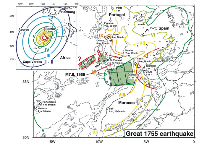
Shakemap of the Great Lisbon Earthquake. (Gutscher et al., 2006)
Best estimates are that between 10,000 and 15,000 people died within the city of Lisbon. Many died later due to injuries, fires, and tsunamis and outside the city limits, hence giving the higher numbers often cited elsewhere. As to the damage, many of the finer buildings in the city were mostly ruined and smaller houses and shops were completely destroyed. Observers in ships were said to see the city swaying corn before the buildings collapsed. These estimates and observations are based on eyewitness accounts in The Lisbon Earthquake by T. D. Kendrick.
However, contrary to what was believed (at least by Candide at the time), this was not a result of volcanic activity. As you can see on the map below, there aren't even any even any volcanoes on the Iberian Peninsula.
Active, dormant, and extinct volcanoes of the world.
Even with this blown up view of Europe showing any earthquake hazards in Europe, there isn't even a hazard within 1,000 km of Lisbon. And even that one has an uncertain eruption date.

Earthquake Hazard Map of Europe
My guess is that Candide is aware of the volcanic activity and their corresponding earthquakes in Italy and attributed this earthquake to those causes. However this does not have the hallmarks of a volcanic eruption. As the seismograms below can illustrate, volcanic eruptions have a drawn out shaking due to the magma moving through the Earth called harmonic tremors. This provides a steady shaking over a long period of time. Earthquakes due to fault action have a sharp start and peter out fairly quickly (over the course of 1-3 minutes).

Volcanic harmonic tremors

Fault based seismic tremors
The earthquake had to be a result of fault movement then and not volcanic activity, so let's looks at possible plate tectonic activity. Looking at a plate tectonic map of the Iberian Peninsula we have the following:
Fault slip rates along plate tectonic boundaries (http://diapiro.ictja.csic.es/gt/ivone/research_AFEU.html)
There is a plate boundary running right near Lisbon (which is located right about where the "5" is in 0.05 north of the plate boundary). So where would the earthquake epicenter have been? Looking at the map below, a recent study has pinpointed the likely epicenter to being within the Marques de Pombal (Zitellini et al., 2001).
Bathymetric map of the southwestern Iberia with location of seismic stations (Zitellini et al., 2001).
It has also been determined that the cause of the earthquake was likely a shallow, eastward dipping thrust fault (Gutscher et al., 2006). This type of fault zone, along with it's location can cause the amount of damage caused in the fault as well as the following tsunamis that are associated with this fault. It is interesting to note that even though they compare this Lisbon earthquake to a Lima, Peru earthquake as both being caused by volcanic activity, both are actually caused by eastward dipping thrust faults. Lima, Peru was hit and destroyed by an earthquake and tsunami combo in 1746 (history.ac.uk). These events are so similar, that it is no wonder that Voltaire used this example in his writing. Although, he did have the date off, it wasn't "last year" from the Lisbon earthquake, but close enough (9 years prior).
It is estimated that the Lisbon Earthquake had the magnitude of 8.5-9.0 on the moment magnitude scale (the Richter Scale). The Richter Scale measures the amount of energy released from an earthquake. This number is comparable to other earthquakes because it does not care about the amount of damage that occurs. However, this can only really be measured with modern day equipment. Any earthquakes that occurred before the advent of earthquake reading equipment needs to be estimated differently to gain an accurate estimate.
What we can measure without the direct scientific readings of the energy released from the fault is the amount of damage that had been recorded by contemporary media. This information is then translated into the Modified Mercalli Intensity Scale. It is on this scale that we are able to place estimates on the size of the earthquake. Based on this scale, the Lisbon earthquake would likely be at least a IX in the area of Lisbon (as shown on the first map above):
IX |
Violent |
Damage considerable in specially designed structures; well-designed frame structures thrown out of plumb. Damage great in substantial buildings, with partial collapse. Buildings shifted off foundations. |
And due to the construction at the time (wooden and brick houses, high percentage of people living in poverty), this type of damage would wipe out an entire city.
As a final note, the text states that some shaking started about a week later (presumable a week after the original earthquake). These later earthquakes are what are known as aftershocks. Aftershocks are smaller earthquakes than the original, however they can cause just as much, if not more, damage due to the already susceptible state that the city is in from the original earthquake. Aftershocks are fairly common after large earthquakes as the fault settles out from a large movement (USGS). This was the case for the Lisbon earthquake as well (drgeorgepc.com).
References
_by_tsunami_modeling_and_seismic_intensity/links/09e41507675e5267e8000000.pdf
https://archive.org/details/lisbonearthquake010555mbp
http://earth.rice.edu/mtpe/geo/geosphere/hot/volcanoes/volcanoes_b2.html
http://www.preventionweb.net/english/professional/maps/v.php?id=3832
http://diapiro.ictja.csic.es/gt/ivone/research_AFEU.html
http://www.history.ac.uk/reviews/review/932
https://earthquake.usgs.gov/learn/topics/measure.php
https://www2.usgs.gov/faq/categories/9827/3346
http://www.drgeorgepc.com/Tsunami1755Lisbon.html
Paradise Lost (1667) by John Milton
The geological content in the story is rather sparse but I did note one thing that I wanted to mention.
Book V
"Moon, that now meet'st the orient sun, now fly'st,With the fixed stars, fixed in their orb that flies; And ye five other wandering fires, that move In mystic dance not without song, resound His praise, who out of darkness called up light."
I highlighted this paragraph because the "five other wandering fires" refers to the five planets of the Solar System. That got me wondering, when were the planets discovered. If five planets (not including our own) were known by 1667, when did we know about them?
1st Planet Discovered - Earth. Year....duh.
2nd-6th Planets Discovered - Mars, Venus, Mercury, Jupiter, and Saturn can all be seen by the naked eye. So it is impossible to determine exactly when they were discovered but they were known since at least the 2nd century BC (Sachs, 1974).
7th Planet Discovered - Uranus - March 13, 1781. Discovered by William Hershel who realized that it was moving with respect to the stars (meaning that it did not move with the stars. It was doing it's own thing).
8th Planet Discovered - Neptune - September 18, 1846. Discovered by Johann Galle and Heinrich Louis d'Arrest based on predictions by Urbain Le Verrier. Le Verrier predicted there must be another planet further out due to the eccentric orbit of Uranus.
9th Planet Discovered - Pluto - February 18, 1930. Discovered by Clyde Tombaugh who used eccentricities in Neptune's orbit to predict the presence and location of Pluto. It is now known that the "eccentricities" were actually just measurement errors and Tombaugh got lucky.
9th Planet Rescinded - Pluto - August 24, 2006
- Due to the redefinition of what a planet actually is, Pluto's planetary status was revoked. You can read more about it here: Space.com
Through most of history our reliance on the stars for navigation and even for light during the evenings had provided us with the knowledge of 6 of the planets in our Solar System. Only two (based on the current definition of a planet) remained to be discovered.
References
http://www-groups.dcs.st-and.ac.uk/~history/HistTopics/Neptune_and_Pluto.html
http://www.space.com/43-pluto-the-ninth-planet-that-was-a-dwarf.html
http://www.jstor.org/stable/74273?seq=1#page_scan_tab_contents
The World as Will and Presentation (AKA The World as Will and Idea) by Arthur Schopenhauer
The version I used was translated by Richard E. Aquila and David Carus. The World as Will and Presentation was initially published in 1818, however subsequent editions (1844 and 1859), make it difficult to ascertain when certain thoughts were initially developed and written down.
The publication of On the Origin of Species in 1859, shows that every edition of the The World as Will and Presentation was before that publication; before evolution was thrust into the public consciousness. As you can see below, Schopenhauer goes heavily into evolutionary theory without even understanding all of the intricacies that may be involved. He understands not only evolving creatures, but evolving landscapes as well.
Many of the ideas brought up in this book relate to science and religion, a topic that I am greatly interested in, however generally falls outside of the realm of Geology Through Literature posts. For this post I am going to focus on the scientific aspects, with maybe only a sprinkling of the religious aspects of the work.
Volume 1: Book 1: Chapter 7 - Law of Causality
"...the law of causality and corresponding consideration and investigation of nature nonetheless necessarily lead us to the sure assumption that, within time, every more highly organized state of matter initially followed upon a crude one. For example, animals existed before human beings, fish before terrestrial animals, plants still before these, the inorganic prior to anything organic; so as a consequence, the original mass had to pass through a long series of alterations before the first eye could open."
The law of causality is logic that Schopenhauer had used to discredit the Creationist's view of the world. God could not have created the world from nothing, because then there would be an instant where there was nothing before and something after. However, I feel this could also (partially) apply to the Big Bang Theory, where many scientists are unsure of what was before the infinitesimal point that started our universe and some believe that nothing predated it. This theory though does fall in line with the cyclical theory of the universe, where after the universe expands, it then contracts and begins the process all over again.
Appendix (Page 597 in the original work)
"Spinoza says rightly...that even the stone that one throws, if it had consciousness, would believe it flew of its own free will"
This is rather humorous to consider that if a stone has consciousness, that it would assume that it was moving on it's own.
Volume 2: Chapter 4
"The only correct expression for the law of causality is this: every alteration has its cause in another, immediately preceding alteration. If something happens...then something else must have changed just before that, and so on, ascending ad infinitum; for a first cause is as impossible to think as is a beginning of time or a boundary of space."
See the above comment on the law of causality.
Volume 2: Chapter 18
"For not merely do the highest productions of nature, namely living beings, or the complex phenomena of the inorganic world remain unfathomable to us; but even every rock-crystal, every bit of pyrite, is by virtue of its crystallographic, optical, chemical, electrical properties an abyss of incomprehensibility and mysteries for penetrating consideration and investigation."
It's is amazing to consider how far science has come in the 150-200 years since this was initially published. We are now able to physically see into the crystalline structure of individual minerals. We now know more about minerals than we ever dreamed fathomable back in the 1800's.
Volume 2: Chapter 22
"Nature has equipped every animal with the organs needed for its preservation, the weapons for its battle...it thus bestowed upon each of the the most important of the outwardly directed organs, the brain, along with its function, the intellect. The more complex, namely, its organization became, through higher development, the more manifold and specifically determined became its needs, consequently the more difficult and more dependent on opportunity its procurement of their satisfaction. Thus there was need for a wider field of vision, more precise apprehension, and more accurate distinction between things in the external world, in all their circumstances and relations. Accordingly we see powers of presentation and their organs, brain, nerves, and instruments of sense, come ever more completely to the fore, the higher we ascend along the hierarchy of animals; and in proportion as the cerebral system develops, the external world displays itself in consciousness in a manner that is ever more distinct, multifaceted, complete."
He is essentially describing evolution here. More advanced animals take over from more primitive ones. Animals with better vision took over from those with worse vision. Animals with higher cognitive functions took over from those with less. This goes to show that evolution was on people's minds even before Darwin.
Volume 2: Chapter 23
"Through the different combinations produced by the constant change of positions of these three heavenly bodies (the Earth, Moon, and Sun) relative to one another, the movement of the moon is now accelerated, now decelerated, and it now approaches, now recedes from the earth: this however, in turn, differently at the earth's perihelion than at its aphelion, all of which taken together introduces such an irregularity into the course of the moon that it takes on an actual appearance of capriciousness, in that even Kepler's second law no longer remains invariably valid, but rather it describes unequal areas in time."
The moon does actually speed up and slow down, depending on where it is in it's orbit. As stated by Fourmilab:
"When the Moon is closer to the Earth, around perigee, its orbital motion is faster and carries it past the Earth faster than its constant rotation speed. When the Moon is near apogee, its slower orbital motion causes the rotation to get ahead of the orbital motion..."
But Schopenhauer adds that the sun's influence on the moon's orbit causes the speed of the moon to become practically unpredictable. This is not the case in modern day society, only very difficult, because not only does the Earth and Sun affect the moon's orbit but so do other planets, especially Jupiter, with the second largest gravity shadow in the Solar System.
Volume 2: Chapter 24
"However, it seems that the original generation of organic forms, the production of species themselves, is almost as difficult for nature to carry out as for us to comprehend; this is indicated in particular by its so altogether quite inordinate provision for the preservation of species once they exist. Nonetheless, on the present surface of this planet, the will for life has acted out the full range of its objectification three times, entirely independently of one another, with different modulations, but also with great difference in the degree and extent of completeness. Namely, as is well known, the Old World, America, and Australia all have their own unique series of animals, independent of and entirely different from those of the other two. On each of these great continents, the species are altogether different, but yet have, because all three belong to the same planet, a thoroughgoing and running analogy with one another, which is why the genera are for the most part the same. In Australia, this analogy can be pursued only to a very incomplete extent, because its fauna are very impoverished in regard to mammals, and contain neither predators nor apes; by contrast, between the Old World and America the analogy is evident, and in particular in such a way that America always displays the poorer analogue among mammals, but to the contrary the better among birds and reptiles. Thus it certainly has the advantage of the condor, the macaw, the humming-bird, and the largest amphibians and water-snakes; but it h as, e.g., instead of the elephant, only the tapir; instead of the lion, the cougar; instead of the tiger, the jaguar; instead of the camel, the llama; and instead of true apes, only long-tailed monkeys. It may be concluded from this last defect that nature was unable to rise to the development of human beings in America; for even from the closest level below, namely from the chimpanzee and orangutan, or pongo, the step to the human was still inordinately large. Accordingly, we find-equally primordial on indubitable physiological as well as linguistic grounds-the three races of man, the Caucasian, Mongolian, and Ethiopian, only at home in the Old World, with America by contrast populated by a mixed, or climatically modified, Mongolian stock that must have come over from Asia. On the surface of the earth immediately preceding the present, things had developed as far as apes in places, but not as far as human beings."
This is an old view of evolution, where it seems like life evolved completely separately on the different continents. This is long before plate tectonic theory, which has shown that the plates were once connected (many times connected in the past actually). Looking at his hypothesis though, that Australian animal life is the least like the other continents makes sense in a modern context with plate tectonics. This is because it separated off of the main land mass much earlier than the other continents.
I find these old views of science fascinating because they are right in many ways, but also wrong in many ways, and it is where they are wrong that you can pinpoint the evolution of the science.
Volume 2: Chapter 26
"...every bone of the human hand and arm finds it analogue in the fin of the whale, the skull of the bird in the egg has exactly as many bones as that of the human fetus, and so on. All of this, namely, points to a principle that is independent of teleology, but that is the fundament on which it builds, or pregiven material for its works, and precisely that which Geoffroy Saint-Hilaire has propounded as the 'anatomical element'"
Another instance of evolutionary study. Where bones are analogous across species.
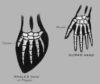
Whale fin to human hand comparison. ReadMoby.com
"...nature does not start from the beginning with every production and create out of nothing, but rather, continuing to write as it were in the same style, adds to what exists, utilizes, develops, and potentiates previous forms so as to carry its work further: just as it has done in the ascending series of animals, entirely in accordance with the rule, 'Nature makes no leaps, and takes the most convenient path in all its operations' (Aristotle, de incessu animalium, chs 2 and 8)"
More evolution. Continued change through time. Starting with the last step and advancing from there.
Volume 2: Chapter 36
"...science frees the understanding from the bonds of ignorance"
This is just common sense in my book.
Volume 2: Chapter 46
"The fossils of entirely different kinds of animal species formerly inhabiting the planet provide us, as proof of our reckoning, with records of worlds whose subsistence was no longer possible, which were therefore even worse than the worst of those possible."
He is stating that the world is already pretty bad now, but fossils show us that animals unlike modern day animals were worse off in the past because they couldn't survive in that world. With this Schopenhauer is describing changing climates. That not only does the animals change (through evolution) but the land is also changing. He grasps, back in the early 1800's, that we live in an ever evolving world. Something that many people in the modern don't understand or grasp.
References
https://www.fourmilab.ch/earthview/moon_ap_per.html
http://www.readmoby.com/pops/whalefin_humanhand.html
Vanity Fair by William Thackeray
Chapter XXV
There was only one instance of geology brought up in the story but it was one I had not thought about before.
"Who'd think the moon was two hundred and thirty-six thousand eight hundred and forty-seven miles off?"
This made me question when we actually figured out the distance between the Earth and the Moon. This story was written in 1848 and that seems very early compared to our modern day scientific techniques.
According to Nasa, the Earth is an average of 238,855 miles away, not that far off of the 236,847 miles quoted in the novel. And actually the distance between the Earth and Moon changes depending on the orbit. It goes from 225,623 miles up to 252,088 miles away
(Space.com). So in reality, the novels distance quote was spot on.
The distance from the Earth to the Moon was determined way earlier than the 1800's. In 270 BC, Aristarchus derived the Moon's distances using a lunar eclipse. The Greeks had already known the Earth was a sphere and that the Moon orbited the Earth (since it was assumed everything orbited the Earth at that time). He used this information, along with the duration of one lunar orbit (~a month) and the time it takes to fully cross through the Earth's shadow during an eclipse to determine that the Moon is about 60 Earth's away from the Earth. Without the actual Earth radius though, this couldn't be more refined, until Eratosthenes determine the Earth's circumference a couple of decades later (as discussed earlier).
More detail on the mathematics of Aristarchus' calculations can be found on Nasa's website:
http://www-istp.gsfc.nasa.gov/stargaze/Shipprc2.htm
Another method was developed by Hipparchus to measure the distance between the Earth and the Moon using a total eclispe of the sun. You can read about his methods here:
http://www-istp.gsfc.nasa.gov/stargaze/Shipparc.htm
References
http://spaceplace.nasa.gov/moon-distance/en/
http://www.space.com/18145-how-far-is-the-moon.html
http://www-istp.gsfc.nasa.gov/stargaze/Shipprc2.htm
http://www-istp.gsfc.nasa.gov/stargaze/Shipparc.htm
Part Two: Act I
"MEPHISTOPHELES: Wherever you go in this world there's always a shortage of something. It might be this, it might be that. Here it's money we're short of. Now you can't just pick up money from the floor. But there's nothing sunk so deep we con't get hold of it, if we use our wits. There's gold, coined and uncoined, under old walls or in the belly of the hills. And if you ask me who is to unearth it: An intelligent man using the brains that nature gave him."
Some good ole hard work and intelligence has helped many a geologist to find precious metals and other goodies that the earth has buried deep within it.
Part Two: Act II - Earthquakes
(Earthquake)
SIRENS: The water came foaming back, but not in its old bed. The ground quaked, the flood piled up, the shore cracked and smoked. Let's away from here, all of us. This miracle's no good to anyone. Away to the sea-festival, all you guests, where the glinting, trembling waves lightly lap the shore, and the moon shines double and wets us with its sacred dew. Life there is unconfined, and here - this fearful earthquake. The place is dreadful. No prudent man would stay.
SEISMOS: (making noises under the earth)
Another good shove. Another good heave with my shoulders. Then I'll be out and they'll all have to scatter.
SPHINXES: What a horrid vibration. What fearful tension in the air. Such a swaying and tottering and rocking this way and that. It's intolerable, it's monstrous. But we won't move, though hell itself breaks loose. The ground's lifting like a vaulted roof, marvelous. It's the same old man, the same old greybeard, who made the island of Delos, pushed it up out of the sea to oblige a woman in travail. Now straining and squeezing away untiringly with all his might, his arms tensed and his back bent like the giant Atlas, he's lifting the grass, the soil, the sand, and everything in the peaceful river-bed, and cutting a gap right across the quiet valley. He's like a colossal caryatid, still buried below the waist and holding up a huge mass of rock. But this is where he stops, because we're here.
SEISMOS: I managed this all by myself. You'll have to admit it. And if I hadn't done so much shoving and shaking, how would it have been with this lovely world? You'd never have had your mountains towering aloft against the blue sky in its purity and splendour if I hadn't thrust them up for your pleasure, showing off in front of our great ancestors, Chaos and Old Night, and in company with the titans tossing Pelion and Ossa about like playthings. We carried on this way in youthful exuberance till we got tired of it and wickedly clapped the two mountains on top of Parnassus as a double night-cap...Apollo sojourns happily there with his muses. And who was it but me that planted the throne on high for Jupiter and his thunderbolts? Now once more I've force my way with an immense effort out of the bowels of the earth and call for happy settlers to begin a new life here.
In the first part of the section, I believe they are referring to an earthquake triggering a tsunami. "The water came foaming back, but not in its old bed." Tsunamis are frequent with earthquakes, especially earthquakes with their epicenter's under the ocean. Depending on the type of earthquake, what sometimes occurs is that during the initial ground movement, the ocean floor drops down, then quickly bounces back up. This sudden water displacement is one method in which a tsunami can be set in motion (nasa.gov).
The next part refers to the earthquake lifting land out of the sea, such as had happened with the island of Delos. Land being shifted upwards due to fault displacement is nowhere near an unheard of thing. As you can see in Chile, the coastline was uplifted during the 8.8 earthquake a few years ago, creating a new coastline. Since many earthquakes affect land not associated with a coastline it was difficult to determine relative changes in elevation, especially beneath the ocean. However, with modern GPS and other analytical methods, it is much easier and quicker to determine precise earthquake displacements not associated with a constant, like sea level, such as the rise in the ocean floor after the 2011 Japanese Earthquake.
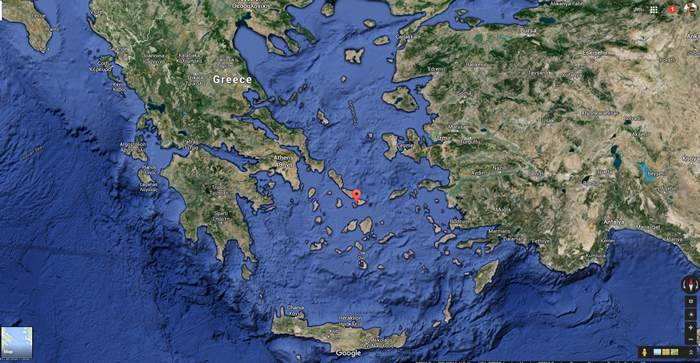
Location of Delos, Greece
Has this happened in Greece though, specifically the island of Delos? Greece is far from a tectonically inactive area. They have been known to have earthquakes all through recorded history, however Delos sits in an area or relative stability compared with surrounding areas. In actuality, over the past few thousand years Delos has fluctuated up and down, with an overall subsiding trend. This fluctuation is likely what made it seem like Delos has remained stable through time (Pavlopoulos et al., 2011). So, even though it is stated that Delos was pushed out of the sea, it is more likely that Delos has always been out of the sea (during recorded history) and is currently slowly making it's way back.
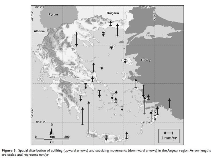
Figure 5 from Pavlopoulos et al. (2011) showing that the area surrounding Delos is relatively stable, with Delos in particular subsiding over time.
Part Two: Act II - Rocks
ANAXAGORAS to Thales:
Will that rigid mind of yours never relent? What more is needed to convince you?
THALES:
Water yields to any wind, but it keeps away from the sharp rock.
ANAXAGORAS:
This rock was made by explosion, by fire.
THALES:
Life began in the wet.
HOMUNCULUS between the two:
Let me go with you. I also want to begin.
ANAXAGORAS:
Tell me, Thales, did you ever, in one night, make a mountain out of mud?
THALES:
Nature, the flow of nature, never depended on hours and days. She lets every form grow under her control. Even on a big scale there's no violence.
ANAXAGORAS:
But there was violence here. Cruel, plutonic fire, the tremendous bursting of aeolian vapous, broke through the old flat crust, so that at once a mountain had to arise.
THALES:
What does it help? What does it lead to? The mountain's there. So far, so good. This sort of argument's a waste of time. It only leads people by the nose, if they let it.
ANAXAGORAS:
The mountain's already alive with myrmidons, occupying the cracks. Ants and pygmies and other little busy-bodies.
The first part brings up the point "Life began in the wet". It is pretty well assumed that life did indeed first evolve in the water, due to the need for a transportation medium between adjacent components. Current research indicates that these components needed for life could have been brought in by the comet bombardment that saturated Earth in the early days (Sciencemag.org).
The second part that I would like to address was the violence of the plutonic fire as it broke through the flat crust. What is being described here is the violence often associated with volcanic eruptions, especially explosive ones. The mountain building being described I take as the accumulation of lava on the surface to produce land, where there once was none.
On a related note, there is a rather interesting story about the cinder cone volcano, Parícutin, that arose in a farmer's corn field in Mexico. Over the course of the first 4 months since it's initial eruption, the volcano went from nothing to 200 meters tall. This continued and is currently 424 meters high (Smithsonian National Museum of Natural History).
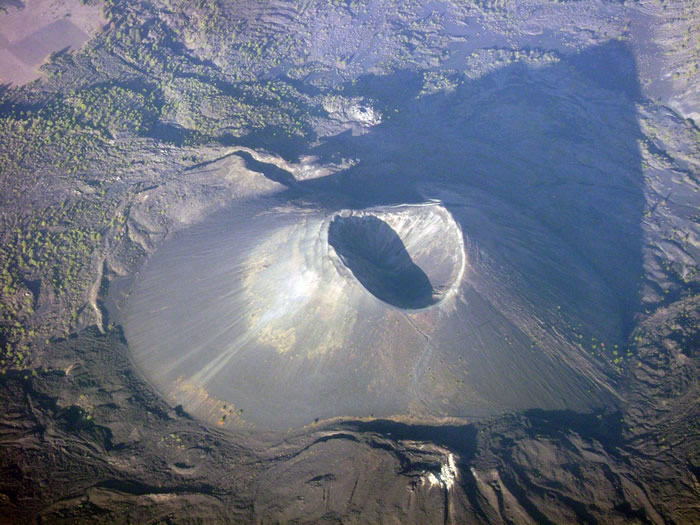
So, it is possible for a mountain to rise from nothing over a very short span of time. The number of earthquakes associated with the rise of Parícutin also increased exponentially immediately before the beginnings of the volcano. Perhaps Seismos had something to do with this one.
References
http://earthobservatory.nasa.gov/NaturalHazards/view.php?id=14406
http://io9.com/5603563/how-the-chile-earthquake-created-miles-of-new-uplifted-coastline/
https://en.wikipedia.org/wiki/List_of_earthquakes_in_Greece
http://news.sciencemag.org/biology/2015/03/researchers-may-have-solved-origin-life-conundrum
http://www.ign.com/boards/threads/culture-porn-7-14-2013-par%C3%ADcutin.453191319/
http://www.mnh.si.edu/onehundredyears/expeditions/Paricutin.html
Pavlopoulos, K., Kapsimalis, V., Theodorakopoulou, K., and Panagiotopoulos, I. P. 2011. Vertical displacement trends in the Aegean coastal zone (NE Mediterranean) during the Holocene assessed by geo-archaeological data. The Holocene. v. 22 no. 6. pp. 717-728
Don Quixote by Miguel de Cervantes
The story is basically a man who has gone "mad", or more likely has dementia, who wants to rebuild the knights of old in Spain during a time period when they are considered by most to be merely legends. To do this he battles giants (windmills), evil villains (other people passing by), and massive armies of people (sheep).
Although Don Quixote is a rather long book (over 1,000 pages) there is not much in the way of geological content. There are however, two scientifically related parts I would like to point out.
Part II, Book V, Chapter I
"Besides in Sicily thigh-bones and shoulder-bones have been found of so immense a size, that from thence of necessity we must conclude by the certain rules of geometry, that the men to whom they belong'd were giants, as big as huge steeples."
This is actually a real life occurrence! For thousands of years people had been unearthing extinct dwarf elephant bones on Sicily, Italy. The people who had unearthed these remains had thought they were the remnants of giants, and not just any giants, it was where the origin of the cyclops began. The skull of a dwarf elephant looks a lot like a human skull with one giant hole in it where the "eye socket" was. Because of reverence for the dead, these remains were often reburied, however now they were laid to rest in a more human like pose. When future people uncovered these now reburied remains, there was really no reason for them not to think that these were the remnants of ancient giants.
Dwarf elephant skull from Sicily, (c) AMNH
Part II, Book V, Chapter XVIII
"With that addressing himself to Don Quixote, Sir, said he, you seem to me to have frequented the schools; pray what science has been your particular study? That of Knight-Errantry, answer'd Don Quixote, which is as good as that of Poetry, and somewhat better too. I don't know what sort of a science that is, said Don Lorenzo, nor indeed did I ever hear of it before. 'Tis a science answer'd Don Quixote, that includes in itself all the other sciences in the world, or at least the greatest part of them: Whoever professes it, ought to be learned in the laws, and understand distributive and commutative Justice, in order to right all mankind. He ought to be a Divine, to give reason of his faith, and vindicate his religion by dint of argument. He ought to be skill'd in Physick, especially in the Botanick part of it, that he may know the nature of simples, and have recourse to those herbs that can cure wounds; for a Knight-Errant must not expect to find surgeons in the woods and desarts. He must be an Astronomer, to understand the motions of the celestial orbs, and find out by the stars the hour of the night, and the longitude and latitude of the climate on which fortune throws him; and he ought to be well instructed in all the other parts of the mathematicks, that science being of constant use to a professor of arms, on many accounts too numerous to be related. I need not tell you, that all the divine and moral virtues must center in his mind."
Although, this passage is not strictly geologically related, I found it interesting in that he seems want to list all the major "sciences" of his day (early 1600's). This is a satirical story though and only so much should be read into what sciences the author deemed important.
References
http://www.jasoncolavito.com/blog/a-giant-unearthed-in-early-nineteenth-century-sicily
http://www.amnh.org/education/resources/rfl/web/mythicguide/teaching.html
https://www.youtube.com/watch?v=L-4r3DkOgqE
A Connecticut Yankee in King Arthur's Court by Mark Twain
This story is essentially a time travel story so there are several aspects of "historical geology" in play for the book. The first part involves the occurrence of a solar eclipse.
"I knew that the only total eclipse of the sun in the first half of the sixth century occurred on the 21st of June, A.D. 528, O.S., and began at 3 minutes after 12 noon. I also knew that no total eclipse of the sun was due in what me was the present year --i.e., 1879." Chapter 2
As the story progresses it turns out that the narrator had the incorrect day and actually the eclipse occurred on the 20th. However that small change of a day does not really effect our interpretation in a scientific aspect.
The benefit of determining when solar eclipses have happened in the past is that eclipses have a pattern to them. They occur in cycles due to the repetitive motions of the sun, moon, and Earth. And it is possible to calculate out when exactly eclipses have occurred or will likely to occur. Luckily NASA has already done this for us. The link goes to a document which catalogs all of the eclipses that have occurred from 2000 BC estimated up through 3000 AD. Unfortunately, Twain did not have access to such a document, or even the knowledge of when eclipses occurred. Since there are no written records from the sixth century listing all of the solar eclipses we have to assume that what is in the list is mostly accurate. There is a possibility that the dates and the times may be off, but there is a strong certainty that they are not off by much. According to the list, there were 4 eclipses during the year 528 (Feb 6th, Mar 6th, Aug 1st, Aug 30th). And even then, only two of those were visible in the northern hemisphere (Feb 6th and Aug 30th). So even with problems linking up the calendars (prior to 1582 a different calendar was used, the Julian calendar), it is unlikely that there was any total eclipse during 528 AD and not even a partial one in May, June, or July (the months surrounding the incident in the book).

The narrator also mentions that there was a total eclipse in 1879. There were 2 eclipses in 1879 (Jan 22nd and Jul 19th). Both of these are listed as Annular Solar Eclipses, which means that the moon is too far from the Earth to completely cover the sun (as pictured above) and produces what is known as a "ring of fire". So, even though this is not a total solar eclipse, it is rather noticeable, and could be thought of in a similar sense since the moon is entirely in front of the sun. This essentially negates both of the assumptions in the book based on the eclipses. So based on this, I would not be using A Connecticut Yankee in King Arthur's Court for my eclipse estimations.
The second entry has to do with the formation of geology as a science in general.
"He said the most of Sir Dinadan's jokes were rotten and the rest were petrified. I said "petrified" was good; as I believed, myself, that the only right way to classify the majestic ages of some of those jokes was by geologic periods. But that neat idea hit the boy in a blank place, for geology hadn't been invented yet. He failed to catch on. However, I made a note of the remark, and calculated to educate the commonwealth up to it if I pulled through. It is no use to throw a good thing away merely because the market isn't ripe yet." Chapter 4
Geology in and of itself is an ancient study. It is known from the period of Aristotle, where he made comments on the geological rates of features. One of his pupils, Theophrastus, who was born in 371 BC also wrote up a book called On Stones where:
"...he goes on to classify them based on their reaction to heat, on their hardnesses, and on their power of attraction. He describes a great variety of stones according to their use and origins. He writes on coal and it's use as a source of heat by metal-workers, he writes on the minerals used on the fabrication of glass, of different pigments, of plaster. He traces the origins of pumice-stones to volcanos, of pearls to shell-fish, and speaks about fossilized remains of organic life. Theophrastus was also the first known person to have made reference to pyroelectricity, the capacity, by certain materials, to produce voltage when heated or cooled. From his text as well as from a later text by Pliny the Elder (Naturalis Historia from 77AD) the science of mineralogy emerged, arguably the founding science for geology."
Theophrastus could be considered as one of the founders of geology. However, modern geology does have a significantly different approach to it. The introduction of modern geology took a long road from these origins though. There are a couple of people who are credited with having founded modern geology. One of them being Nicholas Steno (1638-1686), who is credited with the main laws of stratigraphy: The law of superposition (the stuff on the bottom is older than the stuff on top), the principle of original horizontality (rocks are laid down horizontally), and principle of lateral continuity (rock units stretch over large areas of land). Later works by James Hutton (1726-1797) , such as his published ideas on uniformitarianism (everything happening now has happened in the past) are also credited with ushering us into the modern age of geological thought. Hutton is often considered to be the Father of Modern Geology although Steno surely also has a significant place at the top.
The narrator's comment also plays into the concept of the age of the Earth. The boy in the quote was not used to thinking of the Earth as an old place. To people before 1600, the bible was seen as a literal truth where everyone thought that the Earth was 6,000 years old. In the narrator's own time (1879 as mentioned before), Lord Kelvin had just estimated the Earth to be about 98 millions years old. Even though this is far younger than we now understand the Earth to be (4.55 billion years old), the narrator still understood his Earth to be much older than that of the boy in his presence. This lends weight to his "majestic ages" comment, where millions of years denotes the ages quite a bit better than thousands of years.
This paragraph involves two aspects of Historical Geology. The first part is that even though geological concepts were thought of prior to the "inventing of geology" in the 16 to 17 hundreds, it is possible to say that geology had not been "invented" yet. And it is without modern geology that the true age of the Earth was unknown with the only source for that information having been the Bible, which would have placed that age approximately 6,000 years before. The Earth being a very old place was the basis of the joke which the narrator tells to the boy, and without that long age, the joke would likely have fell on deaf ears.
The Way of All Flesh by Samuel Butler
Not much in the way of geology in this book, however I did find a couple of passages interesting. The book mainly is about Christianity taking place in the 1800's and a couple of passages mention some recent works that were released:
"It must be remembered that the year 1858 was the last of a term during which the peace of the Church of England was singularly unbroken... I need hardly say that the calm was only on the surface. Older men, who knew more than undergraduates are likely to do, must have seen that the wave of skepticism which had already broken over Germany was setting towards our own shores (England) - nor was it long, indeed, before it reached them. Ernest had hardly been ordained before three works in quick succession arrested the attention even of those who paid least heed to theological controversy - I mean Essays and Reviews, Charles Darwin's Origin of Species, and Bishop Colenso's Criticisms on the Pentateuch."
As a little bit of a background, On the Origin of Species was originally published November 24th, 1859, while events during the first paragraph take place during 1858. Even though The Way of All Flesh was published in 1903, Butler began working on it in 1873. This shows that, the upheaval due to the publishing of several works like On the Origin of Species still would have been fresh in his mind. Although, the ideas of evolution were slowly gaining hold, even before Darwin's publication, the Church of England firmly held the beliefs as posed in the Bible. Mainly, that species were created by their Creator and have remained unchanged since creation. Darwin's (among others) theories flew in the face of that, hence the paragraph describing the breakdown of the Church of England's hold. Very fitting for a book that seems to be very anti-established church.
"This was the course things have taken in the Church of England during the last forty years. The set has been steadily in one direction. A few men who knew what they wanted made catspaw of the Christinas and the Charlottes, and the Christinas and the Charlottes made catspaws of the Mrs. Goodhews and the old Miss Wrights, and the Mrs. Goodhews and old Miss Wrights told the Mr. Goodhews and the young Miss Wrights what they should do, and when the Mr. Goodhews and the young Miss Wrights did it the little Goodhews and the rest of the spiritual flock did as they did, and the Theobalds went for nothing; step by step, day by day, year by year, parish by parish, diocese by diocese, this was how it was done. And yet the Church of England looks with no friendly eyes upon the theory of evolution, or decent with modification."
I like this passage because it shows how "descent with modification" (i.e. evolution) works in the context of society. My personal point of view is that many people take the term "evolution" out of context, where it simply means "change over time". Also, Darwin never stated the term "evolution" within the Origin of Species. He just used "descent with modification", so I feel that the author's phrasing in the last sentence as a hat-tip to the original term.
Using The Travels of Marco Polo by Marco Polo
While seeming to offer no geological significance, several works can still be used to describe the beauty available in the natural world. The Travels of Marco Polo provides a first person narrative of the travels of Marco Polo across Asia and India during the 12th century. It is this unique perspective that we gain insight into a land and culture that otherwise would be unknown to the outside world of today. Although Marco Polo generally commented on the cultural aspects of the people in which he interacted, he sometimes referred to the geological aspects of the lands and how the people interacted with that geology. It is in these parts that we will focus our attention.
Part 1 - Book 2: Chapter 23
Read Book 2: Chapter 23 (Of the kind of wine made in the province of Cathay - And of the stones used there for burning n the manner of charcoal). A snippet of the chapter is provided below:
"Throughout this province there is found a sort of black stone, which they dig out of the mountains, where it runs in veins. When lighted, it burns like charcoal, and retains the fire much better than wood; insomuch that it may be preserved during the night, and in the morning be found still burning. These stones do not flame, excepting a little when first lighted, but during their ignition give out a considerable heat."
A Breakdown:
Based on the description of the rocks that Marco Polo had seen, it is clear that he is referring to coal. The province of Cathay is now known as northern China. Looking at the Chinese Coal map below, you can see that there are abundant coal mines across northwestern China, emphasizing the point that Marco Polo was referencing coal in his chapter. There is also evidence that the Chinese have been excavating coal for the past 3500 years. One of the big questions, though is if Marco Polo would have known about coal. In Europe, during Marco Polo's time and before, there were significant coal mines in the 2nd century AD in the UK region conducted by the Romans. However, following the exit of the Romans there were no significant uses of the coal until the 12th century AD, around the time of Marco Polo. And even then, it appears that most of the mined coal remained within the UK region. It wasn't until the 15th century that Britain started to trade coal with the rest of Europe. This makes it plausible that Marco Polo didn't know about the existence of coal.

Some Possible Questions:
1. What rock is being described here?
2. Is the Province of Cathay known for this type of rock?
3. Is it reasonable to assume that Marco Polo wouldn't know about this type of rock in his day ~1250 to 1300 AD?
Part 2 - Book 2: Chapter 27
Read Book 2: Chapter 27 (Of the river named Pulisangan, and of the bridge over it).
"Over this river there is a very handsome bridge of stone, perhaps unequaled by another in the world. It's length is three hundred paces, and its width eight paces; so that ten men can, without inconvenience, ride abreast. It has twenty-four arches, supported by twenty-five piers erected in the water, all of serpentine stone, and built with great skill. On each side, and from one extremity to the other, there is a handsome parapet, formed of marble slabs and pillars arranged in a masterly style... Upon the upper level there is a massive and lofty column, resting upon a tortoise of marble, and having near its base a large figure of a lion, with a lion also on the top. Towards the slope of the bridge there is another handsome column or pillar, with its lion, at the distance of a pace and a half from the former; and all the spaces between one pillar and another, throughout the whole length of the bridge, are filled up with slabs of marble, curiously sculptured, and mortised into the next adjoining pillars, which are, in like manner, a pace and half asunder, and equally surmounted with lions, forming altogether a beautiful spectacle."
A Breakdown:
The Lugou Qiao Bridge, or the Marco Polo Bridge as it is more commonly known as, still stands today. As described by Marco Polo it contains abundant marble lions statues placed throughout the length of the bridge. Marco Polo's text states that the pillars are made of "serpentine stone", however I can find no mention of the serpentine stone and he may have mistaken a different variety of marble for serpentine. An interesting note though is that it is often referred that it is impossible to determine how many lions are on the bridge since the statues of the lions contain more lions carved between the feet of the lions.
Some Possible Questions:
1. What types rocks have been included in the bridge construction (i.e. sandstone, basalt, etc.)?
2. Is this bridge still around today?
3. What does that say about the materials used to build the bridge (good, bad, etc.) and was it a good idea to build it in this way?
4. What other name is this bridge also known as?
Part 3 - Book 3: Chapter 19
Read Book 3: Chapter 19 (Of the island of Zeilan). A snippet of the chapter is provided below:
"(The island of Zeilan [Ceylon]) is in circuit two thousand four hundred miles, but in ancient times it was still larger, its circumference then measuring full three thousand six hundred miles, according to what is found in the mariners' map of the world for this ocean. But the northern gales, which blow with prodigious violence, have in a manner corroded the mountains, so that they have in some parts fallen and sunk in the sea, and the island, from that cause, no longer retains its original size."
A Breakdown:
Today, the island of Ceylon is known as Sri Lanka. Modern day measurements place the island at 833 miles in circumference and 25,330 square miles in area. This is significantly smaller than the measurements given by Marco Polo during his time, as well as the measurements given for the historical size of the island. The earlier measurements and map that Marco Polo was referring to was likely a map created by Ptolemy in 150 AD, almost 1,150 years earlier.
There are questions though as to the ability of Ptolemy to actually measure the size of Sri Lanka though, since his map is mostly based off of estimates by sailors and navigators of the time. Marco Polo as well may have had some difficulty in measuring the size of the island, not possessing the same tools that we have today. However, I personally question whether the conversion from prehistoric measurements to modern measurements are correct. There could have been confusion translating between Ptolemy and Marco Polo and then Marco Polo and today, giving another form of error.
Looking at the different size estimates of the island we have:
| Researcher | Date (approx.) |
Circum. (mi) |
Diam. (mi) |
Ptolemy |
150 |
3600 |
1145.92 |
Marco Polo |
1300 |
2400 |
763.94 |
Modern |
2010 |
833 |
265.15 |
| Researcher | Radius (mi) |
Area (sq mi) |
Ptolemy |
572.96 |
1,031,324.03 |
Marco Polo |
381.97 |
458,366.24 |
Modern |
132.58 |
25,330.00 |
| Researcher | Size Difference |
Rate of erosion (sq mi/yr) |
Ptolemy |
|
|
Marco Polo |
572,957.80 |
498.22 |
Modern |
433,036.24 |
609.91 |
If these numbers are correct, then we are looking at rates of erosion of 500 to 600 square miles per year from 150 AD to the present. This is just an astronomical rate and completely unrealistic. The island may be shrinking due to erosion, however there is zero indication that is it shrinking at such an astronomical rate. The possible forces though could change the size of the island are erosion, as stated by Marco Polo, and sea level rise. Erosion alone could not alter the size of the island as dramatically as depicted but sea level rise could, just not over the time period depicted. It is know that historically, humans have been able to walk from India to Sri Lanka across a land bridge produced from drops in sea level. The appearance of this land bridge was last seen about 7,000 years ago though and is far before even Ptolemy's time. The most likely cause for the mysterious shrinking island is inaccuracies in measurements and possibly errors in measurement conversions.
Some Possible Questions:
1. What island is this known as today?
2. What percentage of the island area has eroded away (assuming a circular island with circumference given), according to this description?
3. The earlier map that Marco Polo was referring to is likely a map created by Ptolemy in 150 AD, almost 1,150 years earlier. Calculate out the number of square miles that the island has been shrinking per year (assume 1,140 years has passed).
4. Is this a reasonable rate of erosion?
5. Determine the modern circumference of the island and calculate out the rate of erosion from the last 710 years (Marco Polo's to to approximately modern times. You can use the length of the coastline to calculate a circular area or use the actual area).
6. How do the erosion rates compare?
7. Could Marco Polo's assumption that the island was eroding away be correct or could something else be the cause? Or was Marco Polo incorrect and the island is not shrinking?
Using The Picture of Dorian Gray by Oscar Wilde
While seeming to offer no geological significance, several works can still be used to describe the beauty available in the natural world. One of those works is The Picture of Dorian Gray by Oscar Wilde where in one portion of the book the title character becomes obsessed with gems and minerals. This leads to a rather lengthy discussion and listing of several varieties of gems, minerals, precious metals, and a host of other things (some of which I still am not sure what are).
Project Description
Directions:
Read Chapter 11 (around the middle of the chapter, begins “On one occasion he took up the study of jewels” of Dorian Gray by Oscar Wilde. There are approximately 35 different varieties of gems, minerals, and precious metals mentioned in the text. The minerals mentioned in the text are listed out on the provided sheet.
Questions:
(A website that might be of some use is: http://gwydir.demon.co.uk/jo/minerals/dorian.htm, but I recommend using Google and Yahoo! as a back-up as well since that website does not always give the correct answers). Use the chart below for questions 1, 2, and 3.
- Several of the gems and minerals have multiple colors listed in the text. Write down the colors mentioned on the chart under the Color Variations column.
- Several of the gems and minerals also list special properties in the text. Write down the special properties on the chart under the Special Properties column.
- Gem names are often specific colored varieties of certain minerals (i.e. purple quartz is called amethyst). List what the mineral name is for the open boxes on the chart under the Alias column. (The red boxes I am unable to determine so I will not expect anyone else to determine them either. See Bonus Question 1.)
- There are 4 different varieties of Quartz (or chalcedony, which is a variety of quartz) mentioned. What are those gems mentioned?
- According to Mohs Hardness Scale, which of the minerals/gems mentioned are on the scale? (Fill in the blanks below, multiple blanks means multiple answers)
- 1 – Talc
- 2 – ___________
- 3 – Calcite
- 4 – Fluorite
- 5 – Apatite
- 6 – ____________; ____________
- 7 – ____________; ____________; ____________; ____________;
- 8 – ____________;
- 9 – ____________; ____________;
- 10 – ____________;
- Looking at all the duplicates in the Alias column (i.e. garnet, quartz, etc.) what is the principle difference, other than color, between the different varieties of the same mineral?
- What is the difference between Balas Rubies and regular Rubies?
- Amethyst is mentioned that it “drove away the fumes of wine”. What did the ancient Greeks do with amethyst that helped corroborate this claim?
- Which of the three gems mentioned are not inorganically formed but biologically produced?
Bonus Questions (i.e. harder than normal):
- Fill in the dark red boxes for Aliases of the 3 unknown gems (aspilate, hydropicus, and meloceus). And if you do know what these are let me know as well.
- What is the difference between Turquoise and Turquoise de la vieille roche?
Mineral/ Gems |
Col. Var. |
Spec. Prop. |
Alias |
Agate of India (Agate) |
|
|
|
Amethyst |
|
|
Quartz |
Aspilate |
|
|
|
Balas rubies |
|
|
|
Balasses |
|
|
|
Bezoar |
|
|
Bezoar |
Carbuncle |
|
|
|
Chrysoberyl |
|
|
Chrysoberyl |
Chrysolite |
|
|
|
Cinnamon Stones |
|
|
|
Cornelian |
|
|
|
Cymophane |
|
|
|
Diamond |
|
|
Diamond |
Emeraults |
|
|
|
Emerald |
|
|
|
Garnet |
|
|
Garnet |
Gold |
|
|
Gold |
Hyacinth |
|
|
|
Hydropicus |
|
|
|
Jacinth |
|
|
|
Meloceus |
|
|
|
Moonstone |
|
|
|
Opal |
|
|
Opal |
Orient |
|
|
|
Pearl |
|
|
Pearl |
Peridot |
|
|
|
Ruby |
|
|
|
Sapphire |
|
|
|
Sardius |
|
|
|
Selenite |
|
|
|
Silver |
|
|
Silver |
Spinel |
|
|
Spinel |
Sunstone |
|
|
|
Topaz |
|
|
Topaz |
Turquoise |
|
|
Turquoise |
Turquoise de la vieille roche |
|
|
Turquoise |
Click below for the The Picture of Dorian Gray directions in pdf format.
The Picture of Dorian Gray Directions
Answers can be obtained by directly emailing me at Jazinator@hotmail.com
Using Our Town by Thorton Wilder
Geology is not only useful for a scientific purpose but it can also be used as a scene setter. That is how it is used in Our Town. To give the audience a sense of time and place the narrator of the story describes the history and location of the town including the geology and anthropology. The purpose of this project is to take his description and determine whether it is valid or not. Or could this just be a case of the author taking geological and anthropological words and imputing them into a story, whether they make sense or not?
Project Description
Directions:
1. Read Our Town by Thorton Wilder.
2. Write down all of the important sentences and phrases that describe both the geology of the town and it’s location on a map. You will use this information along with some references from the internet to determine what is correct and what is made up.
3.Use that information to answer the following questions:
Questions:
- What is the name of the town and the state that the story takes place in?
- Does this town actually exist?
- What town is closest to the coordinates given in the text? Is it the town named? Note: The coordinates are given in NAD27 which is an old system but the difference to the more recent NAD83 is only about 10 meters so it should not matter.
- Use the coordinates from the text on the website: http://atlas.mapquest.com/maps/latlong.adp. You have to place a negative “-” in front of the longitude since it is in the Western Hemisphere, otherwise you will get a result in Russia.
- The play mentions four different types of rocks that the town lies on. List the rock types and their respective ages. Note: You do not have a given age.
- Place the rocks in the cross section below with the oldest on the bottom and the youngest on top. Assume the one rock layer without an age is the second youngest.
- Does the comment “I may say it’s some of the oldest land in the world.” make sense regarding the rock that they are speaking about? Why or why not? I recommend using a geologic time scale for this one.
- Using the geology map at http://www.nhgeology.org/nhbedrock.htm (there is a larger pdf on the site) does the age of the granite make sense? Why or Why not?
- Using the above geology map what is the oldest age the granite could actually be. Hint: You should probably look up what rocks make up the Massabesic Gneiss Complex and the Rye Complex.
- Assuming the town is southwest of Manchester, is it possible that one of these rock units could be what was actually described?
- Which one would be most likely?
- Rearrange the rock units with the corrected age of the granite below. Assume the rock unit without an age is now the youngest.
- Is the basalt mentioned logical? You might want to check out http://vulcan.wr.usgs.gov/LivingWith/VolcanicPast/. Why or why not?
- The text mentions some fossils. Which of the four units could be the likely source of the fossils? There may be multiple correct answers.
- Anthropology – What is the name of the Amerindian tribe mentioned in the story that originally occupied the region?
- What is the range this tribe actually covered and does it cover the area given in the story?
- What state is mentioned where the marble building stone comes from?
- Can you get marble here?
- If you can get marble here what is a formation it could have come from? Keep in mind the transportation distances, closer to the town the better. There may be multiple correct answers.
I recommend using this site: http://www.anr.state.vt.us/dec/geo/resourceinx.htm to find where they dig for the marble.
And this site: http://www.anr.state.vt.us/dec/geo/centmap.htm to find the name of the formations.
Click below for the Our Town directions in pdf format.
Answers can be obtained by directly emailing me at Jazinator@hotmail.com
Using Walden by Henry David Thoreau
Science is not a new invention. People have been performing science for many thousands of years. Often they build on the research of those before them and sometimes they start from scratch. The purpose of this project is to use a scientific study from the 19th century to produce a current contour map of lake depth.
The study being described is in Walden by Henry David Thoreau, written before 1854. The book is typically considered “philosophical” literature but in this case he performs the basis of science. He identified a problem, determined how to solve the problem, and then executed the research. Below are a series of assignment questions and directions, however I have also included my answers and some additional information. There is a link at the bottom to the assignment itself without the answers intermingled.
His Problem
Often people would describe the depth of Walden Pond as bottomless. He wished to prove them wrong and determine the actual depth.
His Method
To determine the actual depth of the lake he used the simple method of a rock and string.
His Solution
That’s where you come in.
Project Description
1. Read the “The Pond in winter” chapter of Walden by Thoreau. For reference the important excerpts from the chapter are provided here:
"As I was desirous to recover the long lost bottom of Walden Pond, I surveyed it carefully, before the ice broke up, early in '46, with compass and chain and sounding line. There have been many stories told about the bottom, or rather no bottom, of this pond, which certainly had no foundation for themselves.... Many believed that Walden reached quite through to the other side of the globe.... But I can assure my readers that Walden has a reasonably tight bottom at a not unreasonable, though at an unusual, depth. I fathomed it easily with a cod-line and a stone weighing about a pound and a half, and could tell accurately when the stone left the bottom, by having to pull so much harder before the water got underneath to help me. The greatest depth was exactly one hundred and two feet; to which may be added the five feet which it has risen since, making one hundred and seven feet."
"...this one, which is so unusually deep for its area, appears in a vertical section through its centre not deeper than a shallow plate."
"As I sounded through the ice I could determine the shape of the bottom with greater accuracy than is possible in surveying harbors which do not freeze over, and I was surprised at its general regularity. In the deepest part there are several acres more level than almost any field which is exposed to the sun, wind, and plow. In one instance, on a line arbitrarily chosen, the depth did not vary more than one foot in thirty rods; and generally, near the middle, I could calculate the variation for each one hundred feet in any direction beforehand within three or hour inches."
"... Having noticed that the number indicating the greatest depth was apparently in the centre of the map, I laid a rule on the map lengthwise, and then breadthwise, and found, to my surprise, that the line of greatest length intersected the line of greatest breadth exactly at the point of greatest depth, notwithstanding that the middle is so nearly level, the outline of the pond far from regular, and the extreme length and breadth were got by measuring into the coves...."
"Of five coves, three, or all which had been sounded, were observed to have a bar quite across their mouths and deeper water within, so that the bay tended to be an expansion of water within the land not only horizontally but vertically, and to for a basin or independent pond, the direction of the two capes showing the course of the bar.... In proportion as the mouth of the cove was wider compared with its length, the water over the bar was deeper compared with that in the basin."
2. Write down all important sentences and phrases that have to do with the depth and shape of the pond.
3. Summarize these into only the important points (like the location and depth of the deepest point.
- The deepest point of the lake is 102-107 feet deep and is located at the intersection of the greatest breadth and the greatest width lines.
- There are sandbars that surround the coves creating mini lakes.
- The pond is regular, meaning that the contours are evenly spaced apart.
- The base of the pond is relatively flat.
4. Use one of the outlines of Walden Pond provided to start and outline the important features (deepest point, sand bars, etc.) in pencil.
In order to provide a map that is usable for this exercise, I first took an aerial image of Walden Pond.
This was then traced and the aerial image was removed with the approximate location of Thoreau's cabin added for context.
5. Make a contour depth map (bathymetric map) with 20ft contours. The shore of the lake will be your 0 contour (provided). Then erase all of the mistakes and non-important items on the map so you just have a finalized contour map left.
Following these directions, as well as directions on how to make a contour (bathymetric) map, people should be able to make a fairly accurate Walden Pond bathymetry map.
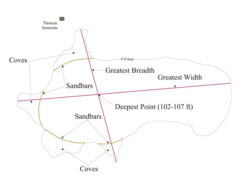
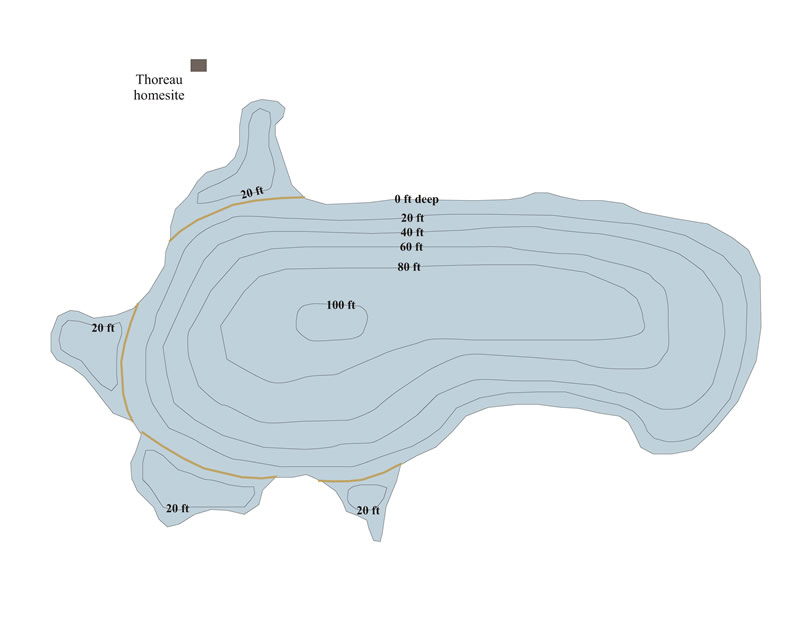
And then students can compare their results with a professional map result called Hydrology and Trophic Ecology of Walden Pond, Concord, Massachusetts by Paul J. Friesz and John A. Colman, 2001 seen below:
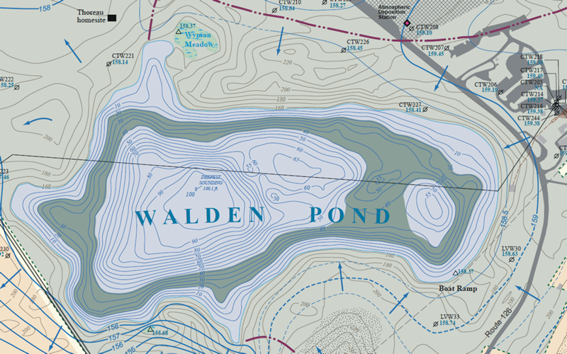
Click below for the Walden directions in pfd format.
Answers can be obtained by directly emailing me at Jazinator@hotmail.com